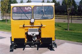
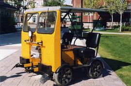
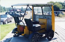
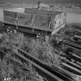
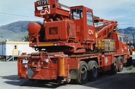
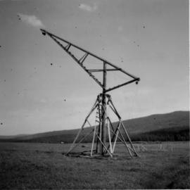
Photograph depicts a hi-rail crane that was located in the Cn Junction yards, Kamloops.
Photograph depicts a hillside flue and a 120 ft. stock of copper smelter that operated from 1901 to 1908. The stock was built sometime between 1903-1909.
Photograph depicts a Fairmont section gang "motor car." Property of Kamloops Heritage Railway. On display at the CNR station in downtown Kamloops.
Photograph depicts the Hedley Gold Mine, 26 miles east of Princeton. Crusher workings.
Photograph depicts the headquarters and general offices of the National Harbours Board in Vancouver, B.C., located at the foot of Dunlery St.
Photograph depicts the head of Burard Inlet in Port Moody.
Photograph depicts the head of Burard Inlet in Port Moody. Looking northwest, towards a locomotive.
Photograph depicts Hazelton Bridge that was believed to be built in 1930. Crossing the Skeena River.
Photograph depicts the Hazelton suspension bridge.
Photograph depicts a hay meadow crane located on a loop road between Ashcroft and Kamloops.
Photograph depicts Hat Creek Staging Hotel, 7 miles north of Cache Creek. The hotel buildig were now part of a farm and contained stores, a cookehouse, and a dormitory.
Photograph depicts a good example of a newly made farm gate.
Photograph depicts the yard at the Hat Creek Ranch. Hat Creek used to be a staging post on the Cariboo Road.
Photograph depicts a harbour seal. Davies' sailboat is in the foreground.
Photograph depicts a harbour seal diving into the water after sunning on a boom log. The bow of Davies' sailboat is in the foreground.
Photograph depicts Coal Harbour in Vancouver. The photo is facing land fill with stone on the tidal side. The site is for the first block of the Harbour Park Development Ltd. high rise apartments.
Photograph depicts the Harbour Park Development site in Coal Harbour, Vancouver. Taking rock from the scow to face fill with anti-erosion material. The site is for new high rise apartments at the edge of Stanley park between Georgia St. and the sea.
Photograph depicts a building that was believed to have had many usess, its last being a fish store.
Photograph depicts the hand truck and track material at Tilbury, Delta in the Fraser Valley. It belongs to the Canadian National Railway (CN)
Photograph depicts a hand car owned by the Kettle Valley Steam Railway. Behind it was a Woodings inspection car.
Photograph depicts a hand car at the Fort Steele Railway Museum. Built by Fairmont of Canada.
Photograph depicts the Hanceville Bridge that went over the Chilcotin River.
Photograph depicts Hamilton St. in Vancouver, looking northeast.
Photograph depicts Hamilton St. in Vancouver. The photo was taken at the back of 1250 Homer St, but is actually on Hamilton St., looking east. The left-hand line is in regular use, but the siding on the right hand side is not.
Photograph depicts the "Haida Chieftain" tug of the Kingcome Navagation Ltd. at their wharf in Vancouver.
Photograph depicts gulls at Lost Lagoon in Vancouver, B.C.
Photograph depicts a 9 car barge called the "Gulf Railroader" and owned by the Gulf of Georgia Towing Company Ltd. It was tied to a CNR slip on Lulu Island, Richmond and was used on the northern arm of the Fraser River shuttle service. The middle car is a flat car filled with high stanchions.
Photograph depicts a 9 car barge called the "Gulf Railroader." It was used on the shuttle service on the northern arm of the Fraser River between the plywod mills in Vancouver and Brunaby as well as the CNR slip on Lulu Island, Richmond.
Photograph depicts the stern view of "Gulf Grenadier," a Canadian easr coast fishing dragger. It had not been in use for about a year.
Photograph depicts a Gruman Goose at the Seal Cove Seaplane Base. Several of these planes were in use at this location. At least 6 in total.
Photograph depicts a Gruman Goose of the Trans Provincial Airpline that had just landed on on floats and was emerging on wheels to climb a ramp to the seaplane base.
Photograph depicts a Gruman Goose of the Trans Provincial Airpline discharging passengers, having just landed on floats and then taxied on wheels up a ramp.
Photograph depicts a set of 4 scale testing cars, consisting of 2 sealed tank cars and 2 special purpose-made cars, one of which was 4-wheeled. Found at the CPR Kamloops yard.
Photograph depicts one of the 4 cars in a scale testing group found at the Kamloops CPR yard.
Photograph depicts a part of a group of 4 scaling testing cars found in the Kamloops CPR yard.
Photograph depicts 2 cars of the group of 4 car 'Scale Test Unit" at the CPR Kamloops yards.
Photograph depicts a grocery store on the main street of Pitt Meadows in the Fraser Valley.
Photograph depicts the Great Northern Railway line in northeastern Washington State in the Columbia River valley. The photo depicts Great Northern Railway (GNR)locomotive #684 with 23 empty ore cars and caboose stopped and deserted at grade crossing, about 8 miles south of Northport, south of Trail. Presumably this line is a spur to a quarry or mine in the hills.
Photograph depicts a Great Northern Railway freight train travelling south over trestle at the south end of a New Westminster rail bridge, at the point where the Great Northern Railway tracks swings westward.
Photograph depicts the Great Northern Railway former station at Cascade, just north of the Canada-U.S. border and 15 miles east of Grand Forks. The line connects Kettle Falls and Grand Forks, but the station is now disused but in good repair. The view is looking south towards Washington State.
Photograph depicts the Great Northern Railway depot at Keremeos and the terminus of the line from Wenatchee, Washington, U.S.A. The line stops about 1/3 mile beyond this point. At one time it ran on to Hedley mine and possibly Princeton.
Photograph depicts the Great Northern Railway station in main street Vancouver. Image captured looking west with the CNR trackage to the left. Lifted track in the foreground used to be depot track. Visible are switchers and a sand car found behind them.
Photograph depicts a Great Northern Railway interchange curve to CPR tracks near Raymur Avenue/ Powell Street, Vancouver. Visible is a part of an export train, consisting of 11 (dead) General Motor locomotives hauled by a GNR switcher towards the Centennial Dock area. The process of destruction was to take place in Pusan by Korean National Railways.
Photograph depicts Raymur Avenue/Powell Street grade crossing. Image captured looking south at Burlington-Northern (former Great Northern Railway) trackage. Visible are the last 4 locomotives of an 11 locomotive (all dead) train hauled by a GN switcher. Export ship was to travel to Korean National Railways, Pusan, Korea.
Photograph depicts trackage of the Great Northern Railway which changed to the Burlington-Northern Railway. The site is not known for sure, but Davies believed it to be near Salmo.
Photograph depicts the Great Northern Railway (now the Burlington-Northern Railway) which had a branch from the states to the states. Salmo was the approximatley the half-way point. The depot in was built in 1923. Facilities included a wye, 18 car siding, and an ore/gravel chute.
Photograph depicts the Great Northern Railway (now the Burlington-Northern Railway) line that ran from Spokane to Nelson. Salmo marked the halfway point of B.C. trackage. The depot in Salmo was built in 1923 and was the most important intermediate station on the line in B.C.