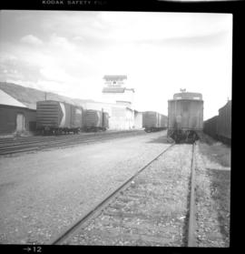
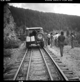
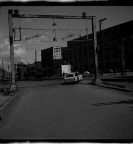
Photograph depicts the CPR grade crossing gates adjacent to the intersection of Alexander and Columbia Streets. The signal (gate control) tower is in the background. The view is looking east.
Photograph depicts the top of the grade coming out of Princeton, going east to Penticton.
Photograph taken in Grand Forks. Between 1900 and 1919, the Granby copper smelter operated on the northern outskirts of the city. Ore was brought to it by CPR and GN lines. Originally had wood coverd deck trusses, but they were later upgraded to steel. All was removed in the 1920's.
Photograph depicts a grand view of the end of the 31st mile. Branch line looking towards Slocan Lake. Located in front is the barge slip to Roseberg and at the right is a lumber mill.
Photograph depicts the 27 mile branch line between Rosebury and Nakusp, looking north towards Nakusp. Officially, "Hills: is at mile 9.2 and was the sight of a former siding. However, since trunction in 1982 , it is now mile 5.3. Rails are consistently CPR 1902, weighing 80 Ibs. This information suggests that the track was relaid at this date (1902) and was never renewed.
Photograph depicts a rail bridge crossing the Fraser River. Right-of-way suggested little usage, but tracks indicated a train had passed within the past 3 days since the photograph was captured.
Photograph depicts a rail bridge crossing the Fraser River. Until 1956, this was the western extremity of the Kettle Valley line, linking up with the CPR main lien to Vancouver. Track now led to derelict looking CPR yards in Hope.
Photograph depicts the CPR yards in Kamloops and the "Bucker Field's" elevator.
Photograph depicts a ballast train that was ready to depart. The caboose was one of 60 built in 1981 at CPR Angus Shops and was the last batch to built before the company closed in 1990.
Photograph depicts a private vehicle that used to hold right-of-way scrap.
Photograph depicts one of the two snow plows that had arrived in January from the northbend and stayed until May. CPR # 401035 built in 1952. It was the 6th last snow plow built for the CPR (majority were built in 1920's).
Photograph depicts westbound freight undergoing a crew change. The second and third locomotives were brand new "Alaska Railways." Presumed to be delivered to Alaska, but the engineer Davies spoke to said that they were on lease to the CPR.
Photograph depicts the CPR Kamloops yard. Looking east from the west end.
Photograph depicts the switchback to gain access to the wharf at Kaslo, looking down graded. Upper part of the track in recent years led to an oil depot, but does not appear to have been used in last 6-12 months (1970).
Photograph depicts a passenger wharf. The waterside of it has not used by the CPR storm-wheelers since 1957. The rail side of it has not been used since [19-?], but the track used 50 yards behind the camera was still used in 1970 by box cars loading dressed lumber. These cars moved by rail tractor back up line for 200 yards then switched to the barge spur which doubles back for about 400 yards south of this wharf.
Photograph depicts the lower end of the switch of the old line between Kaslo and New Denver. In the photo, we are looking toward the south.
Photograph depicts a spur to an oil tank depot (located 200 yards behind the photograph) which does not appear to have been used for about 6-12 months (1970). The platform on the left is being loaded.
Photograph depicts the branch line at old mile 24 between Rosebury and Nakusp or 22 1/2 rail miles south of Nakusp. Track used once per week or every other week. Shot freight passed this point 3 days afterwards. Rails are CPR, dated 1902, weighing 80 Ibs and are consistently laid as a batch.
Photograph depicts the Kaslo Subdivision at the beginning of the branch which connects the Rosebury barge slip (on Slocan Lake) with Nakusp. Technically it is mile 3.9, but in 1983, it is actually about mile 0.2. The bridge is about 60 feet long. The inner gaurd rails are CPR, Kropp. Dated 1883. Weighing about 50 Ibs. Spans Wilson Creek.
Photograph depicts the CPR Kettle Valley Railway mainline in downtown Penticton. It is in the vicinity of Pickering St. and Haywood St. The view is looking southwest.
Photograph depicts the CPR Kettle Valley Railway line in Myra Canyon. This is at about mile 84.75, looking south at the end of Myra canyon.
Photograph depicts the CPR Kettle Valley Railway in Myra Canyon. It shows the vehicle carrying the lunch of the preservation party inspection route. The trip was organized by the Kettle Valley Railway Heritage Society.
Photograph depicts the CPR Kettle Valley Railway in Myra Canyon. The view is looking south and it likely shows a trestle at mile 85.4.
Photograph depicts the Kettle Valley Railway in Myra Canyon. The view is looking south at about mile 85.3.
Photograph depicts the CPR Kettle Valley Railway in Myra Canyon.
Photograph depicts the CPR Kettle Valley Railway in Myra Canyon. The view is looking south into the canyon at about mile 85.
Photograph depicts the CPR Kettle Valley Railway in Myra Canyon. This is at about mile 85 or 86.
Photograph depicts the CPR Kettle Valley Railway in Myra Canyon. This is between mile 85.2 and 85.7.
Photograph depicts the CPR Kettle Valley Railway in Myra Canyon. Motorcyclists are about to cross the trestle at mile 85.4. The view is looking west.
Photograph depicts the CPR Kettle Valley Railway line in Myra Canyon. The view is looking east and upgrade to the Myra depot, which is to the right of the track in the background. At the right is a disused spur at mile 84.2, to the former Penticton Sawmills. Some rail on the spur was dated in the 1880s.
Photograph depicts the CPR Kettle Valley Railway line in Myra Canyon. This is at about mile 84.5, looking south approaching the lip of the canyon.
Photograph depicts the CPR Kettle Valley Railway in Myra Canyon. This is at about mile 85.2, on the edge of the canyon looking north.
Photograph depicts the CPR Kettle Valley Railway in Myra Canyon. The view is looking southeast and includes trestles between mile 85.2 and 85.4.
Photograph depicts the Kettle Valley Railway in Myra Canyon. This is between mile 85.2 and 85.7.
Photograph depicts the CPR Kettle Valley Railway in Myra Canyon. The view is looking north at trestles on the northeastern ledge of the canyon, at about mile 85.2
Photograph depicts the CPR Kettle Valley Railway line in Myra Canyon. This is at about mile 84.5, looking north or upgrade.
Photograph depicts the CPR Kettle Valley line in Myra Canyon and the east fork Canyon Creek Bridge at mile 86.5. It shows the preservation inspection party at the site.
Photograph depicts the CPR Kettle Valley Railway in Myra Canyon. Here at about mile 85.2, the derailment of the "official" Kettle Valley Railway Heritage Society occurred.
Photograph depicts the CPR Kettle Valley Railway in Myra Canyon. The view is at about mile 85.2 and shows a privately owned track car travelling south.
Photograph depicts the CPR Kettle Valley Railway line at about mile 67 from Penticton on the Penticton Subdivision. This is halfway between Belfort and Princeton and is used by freight about 3 times a week. The view is looking south.
Photograph depicts the CPR Faulder depot on the Kettle Valley Railway. It is located at mile 15.5 from Penticton, on the Princeton Subdivision.
Photograph depicts the CPR Kettle Valley Railway line at about mile 20 from Penticton, on the Princeton Subdivision. The view is looking east, downgrade.
Photograph depicts the CPR Kettle Valley Railway line at Faulder, BC. It is located at mile 15.5 from Penticton on the Princeton Subdivision. A very small and unused depot shelter lays behind the camera. The siding has a 70 car capacity being used as storage. The elevation here is 2122 ft. and the view is looking west.
Photograph depicts the CPR Kettle Valley Railway line at about mile 60.5 from Penticton on the Princeton Subdivision. The view is looking northeast and upgrade to the Jura passing loop, just out of sight to the right. The name board here advises the proximity of the siding. The CPR is replacing all the ties along this subdivision.
Photograph depicts the CPR Kettle Valley Railway line at Osprey Lake, approximately 38.8 miles from Penticton, at the summit between Penticton and Princeton. The passing line was removed between 1956 and 1966. A small spur holding 5 cars remains and it was used to store a heavy crane to replace bridge members. The elevation at this point is 3, 606 ft.
Photograph depicts the end of the branch line in Kimberley which is about 3/4 of a mile below the old depot which used to be at Mile 16.3 from the north star June. Maximimum speed on the branch is 20 miles per hour abd 10 miles per hour between mile 3.9 and 7.9.
Photograph depicts the C.P.R. depot at Kimberley. It is in the center of the town, looking up towards the Kimberley mine which is 1 mile away. The last passenger service (1 coach) between Kimberley and Cranbrook ran about 1955.
Photograph taken at mile 59.6. On the right, the image captures grade crossing of CPR Esquimalt & Nanaimo Railway and Comox Logging and Railway Company which is on the left. Camera aimed towards the north. Has a 15 miles per hour speed restriction imposed. Former CPR log interchange yards are found mid-rear. They had not been used for about 5 or 8 years in 1975.
Photograph depicts climax locomotive #10, belonging to Hillcrest Lumber Company Ltd., Mesachie Lake.
Photograph depicts an old type of switch stand about 300 yards from the barge slop on Kootenay Lake (seen in the right half, top corner of the photograph. The stand showed no manufacturers name or date, but is supposed to be early. Stub-switch and rails of 1880 and 1885 date in immmediate vicinity.