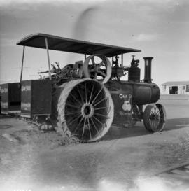
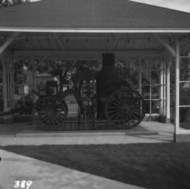
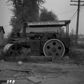
Photograph depicts a 10 ton Wallis & Stevens Ltd. #7985 steam roller. It was built at Basingstoke, England from about 1925 to 1927. It is located at 6110 Curtis St. in Burnaby, BC
Photograph depicts a 1912 steam shovel owned by, and in the gardens of, Neill Brady-Browne. Found on Discovery Rd., Campbell River on Vancouver Island.
Photograph depicts an abandoned coal mine in Coal Creek, 5 miles east of Fernie, BCThe entrance to the mine is unusual and is 2/3rds up the mountainside. The mine was closed in 1959. Flat ground in foreground is littered with at least 100 mine tubs of approximately 3'0' gauge.
Photograph depicts Belmont Park Fort on the west side of Esquimalt Harbour. It was built by the British Royal Engineers in 1895 to protect the naval base. Photo shows the lower fort with 2 gun emplacements.
Photograph depicts the entrance to the magazine feeding gun emplacement in the lower fort of Belmont Park Fort in Esquimalt Harbour.
Photograph depicts one of the 2 gun emplacements in the lower fort of Belmont Park Fort protecting Esquimalt Harbour.
Photograph depicts the one and only gun emplacement in the upper fort of Belmont Park Fort protecting Esquimalt Harbour.
Photograph depicts a boundary post between the U.S. and Canada, on the Canadian side about 2 miles east of Huntingdon in the Fraser Valley.
Photograph depicts a Cariboo Freight Wagon exhibited at Cache Creek, BCThe owner is H.Collins from Cache Creek.
Photograph depicts the coaling wharf at Union Bay on Vancouver Island. It is the property of the Canadian Colliery Resources Ltd. It was last used on August 15, 1960. Thereafter, all equipment and railways were dismantled but the water tank is still standing.
Photograph depicts the coking ovens at Union Bay on Vancouver Island. They belong to the Canadian Collieries Ltd. and the date last used is unknown.
Photograph depicts a C.P.R. steam driven tracked crane at Revelstoke, BCIt was only marked "C.P. Service E.I."
Photograph depicts a derelict copper smelter at Princeton, BC. The ore comes from Copper Mountain.
Photograph depicts a derelict gold mine at Hedley, BC.
Photograph depicts an early internal combustion tractor at Greenwood, BC
Photograph depicts a derelict early type of gas station on the south outskirts of Nanaimo on the old coast road.
Photograph depicts the fire hall at Lillooet, including an old hand drawn hose reel carrier.
Photograph depicts one of the three remaining fire hydrants on location of the former Chinatown in Nanaimo, BCIt was provided and installed by the Chinese and not the city of Nanaimo. The hydrant had no identification marks.
Photograph depicts a First Nations dugout canoe at Lillooet, BCIt is about 10 ft. long.
Photograph depicts one of three fire hydrants in the former Chinatown in Nanaimo, BC Chinatown was destroyed by a fire in 1955. The hydrant as cast initials, "T.C.I.W."
Photograph depicts former tram tracks down east Georgia St. in east Vancouver, BC
Photograph depicts former tram tracks still intact at east Georgia St. and Campbell Ave. in the east end of Vancouver, BCThe tracks continued forward and crossed the low ground on a trestle.
Photograph depicts former tram tracks, looking north from the intersection at Campbell Ave and east Georgia St. in Vancouver, BC
Photograph depicts former tram tracks in Vancouver, BCPhotograph taken from the intersection of Fir St. and a piece (in the left hand of photo) leading to First Ave., with the B.C. Electric Railway behind.
Photograph depicts former tram tracks at the north end of Fu St. on the south side of False Creek in Vancouver, BC
Photograph depicts a Gaar Scott traction engine in working order, steamed twice a year at least. It was built by the M. Rumely Co. in Richmond, Indiana, U.S. The engine is a #16541, has 25 horse power, and 2 cylinders. It was photographed at Texaco Station in Nanton, Alberta. It was owned by Jack burrows of Nanton.
Photograph depicts the rear view of the Gaar Scott traction engine parked at Texcoc Station in Nanton, Alberta. The rear wheels have a 2'9" tread. It was used on farms for haulage, threshing, chaff cutting etc., but not plowing.
Photograph depicts gas pumps and buckboard at Kingsbaker Creek, at the southeast end of Mara Lake on Highway 97A, about 10 miles south of Sicamous.
Photograph depicts a grader at the Cowichan Valley Forest Museum
Photograph depicts a grave in the churchyard of Murray Church in Nicola, near Merritt. The church was built in 1876, which makes it one of the oldest churches in the interior of B.C. The gravestone shows a death in 1882, of a son aged 14.
Photograph depicts a graveyard at a church in Nicola, 7 miles northeast of Merritt. The church was built in 1876, and the cast iron gravestone is unusual.
Photograph depicts the Hedley Gold Mine, 26 miles east of Princeton. Crusher workings.
Photograph depicts a homemade wheel barrow with a leather covered wheel. It was outside an old timer's shed at Porpoise Bay, Sechelt village, on the Sechelt Peninsula.
Photograph depicts a horse drawn wagon at Kingbaker Creek on the southeast end of Mara Lake, south of Sicamous on highway 97A.
Photograph depicts a horse drawn hay rack in a field on the north slopes of Vedder Mountain, near Yarrow.
Photograph depicts a horse drawn steam fire engine on display at Grand Forks.
Photograph depicts a horse drawn wagon in a garden at New Denver, Slocan Lake.
Photograph depicts the mine buildings of the mine at Coal Creek that closed in 1959. The newer buildings date to circa 1930. Much of the standard gauge trackage of Morrissey, Fernie, and Michel railway (subsidiary of the Great Northern Railway) in mine area remains. The track between Coal Creek and Fernie has not been lifted.
Photograph depicts a mine car at Moyie mine, at Moyie, 20 miles south of Cranbrook. The mine produced silver, zinc, and lead, and worked principally from 1900-1910. It is now disused.
Photograph depicts a mine 200 yards south of Moyie village, which is 20 miles south of Cranbrook. It produced silver, zinc, and lead from 1900-1910 and had a smelter a quarter mile away. The shaft was 900 ft. deep, with levels going under Moyie Lake. The head gear dates from 1925-1935 and has electric winding.
Photograph depicts a mine ore car exhibited on the site of the Granby Mine at the ghost town of Phoenix, near Grand Forks.
Photograph depicts a mineral ore (lead or zinc?) mines near the ghost town of Sandon, on the road between Kaslo and New Denver.
Photograph depicts Moyie Lake, 15 miles south of Cranbrook, and Moyie Station. The tailings are from a lead and zinc mine directly to the right of the photograph on the hillside. The view is looking north.
Photograph depicts a notice found on old North Vancouver Ferry #3, moored as a tender at Western Fish Boat Works, Queensborough, Lulu Island. It was signed by the Corporation of North Vancouver.
Photograph depicts an old gas station at 1603 West 3rd Ave. and Fir St. in Vancouver, BC
Photograph depicts one of the few surviving hand operated gas pumps, halfway between Campbell River and Kelsey Bay, BCWithin three months this gas station will have electricity.
Photograph depicts an old hotel sightseeing bus built prior to 1923. It is located at the Cowichan Valley Forest Museum.
Photograph depicts an old pelton wheel at a former quarry at Granite Falls on the northeast head of the Indian Arm.
Photograph depicts an old steam boiler in the garden of a house at Fort Steele, near Cranbrook. It was last used in a pumping house half a mile away, which pumped water from a deep well to residents of the village. The pump house is still standing.
Photograph depicts an old truck in daily use on East Hastings St. in Vancouver, BC