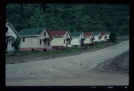
Photograph depicts Businesses in downtown in the North Thompson region, including a business '5 seasons, Sports Excellence'.
Photograph depicts Businesses in downtown in the North Thompson region, including a business called 'Something old & Something new'.
Photograph depicts Businesses in downtown in the North Thompson region, including a sign reading "Welcome to historic George Street" and a business called "Lizard River".
Photograph depicts Businesses in downtown in the North Thompson region, including a sign reading "Welcome to historic George Street" and Levi's jeans store.
Photograph depicts various businesses along 3rd Avenue. The businesses include the Europe Hotel and The Bay in the background. Annotation on verso: "left Europe Hotel, right shearer bldg".
Image depicts a street of businesses, possibly 3rd Avenue, in Prince George, B.C.
Image depicts the welcome sign in Burns Lake, B.C.
Image depicts a street in Burns Lake, B.C.
Image depicts Burns Lake, B.C.
Image depicts bunkhouse, restaurant and store in Sinclair Mills, B.C. Map coordinates 54°01'17.4"N 121°40'53.0"W
Image depicts an old, half-collapsed house in Likely, B.C.. The slide labels it as "Bullion house."
Image depicts a view of Bulkley Valley.
Image depicts a row of buildings in Upper Fraser, B.C. with the store (titled "Paradise") with a Pepsi sign. Map coordinates 54°07'09.1"N 121°56'47.0"W
Image depicts several old buildings in a field, one of which has a caved-in roof, in Newlands, B.C. Map coordinates 54°06'28.2"N 122°12'01.0"W
Image depicts numerous buildings and a dock on the shore of Haida Gwaii, B.C..
Image depicts an unknown building under construction at the corner of 6th Avenue and Dominion Street in Prince George, B.C.
Image depicts a vehicle parked beside a small, wooden house in Upper Fraser, B.C. Map coordinates 54°07'05.7"N 121°56'38.9"W
Photograph depicts Buchanan Benson Real Estate and Insurance at 1276 4th Avenue.
Image depicts an aerial view of the BC Rail, in Prince George, B.C. It is now known as CN Rail.
Image depicts the entrance to a mine with an unknown individual present. It is possibly the entrance to the closed Britannia Mine in the Howe Sound Region.
Image depicts a number of old buildings, possibly located at the closed Britannia Mine.
Image depicts an old building, possibly located at the closed Britannia Mine.
Image depicts a piece of industrial machinery, possibly located at the closed Britannia Mine. Two unknown individuals are also present in the image.
Image depicts a conveyor belt, possibly located inside one of the old buildings at what is possibly the closed Britannia Mine.
Image depicts the inside of a mine with an unknown individual present. It is possibly the inside of the closed Britannia Mine.
Image depicts the Bridge River No. 1 hydroelectric station on the shore of Seton Lake (rear side of powerhouse).
Image depicts a bridge under construction in Tumbler Ridge, B.C.
Image depicts a bridge in Prince George, B.C.
Image depicts the old sales office of Bralorne Pioneer Mines Ltd. which is now the Bralorne Pioneer Museum.
Image depicts what is possibly an old, rundown mill in Bralorne, B.C.
Image depicts a row of houses in Bralorne, B.C.
Image depicts several houses in Bralorne, B.C.
Image depicts a few boarded-up buildings in Bralorne, B.C.
Image depicts a church and a row of houses in Bralorne, B.C.
File contains slides depicting locations in and around Bralorne, B.C.
Image depicts Bralorne, B.C.
Image depicts an area of Barlone, B.C. surrounded by trees.
File contains slides depicting the Bowron Lake Provincial Park.
Image depicts several boats on what appears to be a river, and an old beehive burner in Penny, B.C.
Image depicts a boat docked inside what appears to be a type of boathouse, possibly located in Metlakatla near Prince Rupert, B.C.
Image depicts a boarded up church in Shelley, B.C.