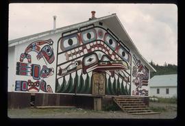
Image depicts an old, abandoned church located somewhere in Seton Portage, B.C.
Image depicts an old abandoned cabin at an uncertain location.
File contains slides depicting the Okanagan Kettle Valley.
File contains slides depicting the Okanagan Brigade Trail.
Image depicts an oddly shaped tree branch that appears to have grown downwards, and is covered in green, mossy growths. Located somewhere on Haida Gwaii.
Image depicts a group of unidentified individuals look through an observatory window at an uncertain location, possibly in Fort St. John, B.C.
Image depicts the Oblates of Mary Immaculate Catholic Church in Aleza Lake, B.C. Map coordinates 54°07'08.2"N 122°02'00.0"W
Image depicts the office at the Northwood Upper Fraser Saw Mill and a sign which reads "Have a safe, quality day." Map coordinates 54.117916, -121.943351
Image depicts the Northwood pulpmill in Prince George B.C.
Image depicts the Northwood Pulpmill in Prince George, B.C. taken from above the Nechako River looking east. Map coordinates 53°56'00.0"N 122°44'29.7"W
Image depicts the Northwood pulpmill in Prince George B.C.
Image depicts the Northwood Bridge crossing in Prince George B.C.
Image depicts the Northwood Bridge in Prince George, B.C.
Image depicts what appears to be a saw mill belonging to Northwood. The location is uncertain.
Image depicts an old building with a sign labelled "Northern Rooms" in an uncertain location somewhere in Prince George, B.C.
Photograph depicts Northern Hardware at 1386 3rd Avenue.
File consists of photographs depicting the North Thompson region. Includes photographs of a CN locomotive, an old barn, and Blue River Store. Also includes photographs of Trelle Morrow and Jim Rankin at the Soda Creek Cemetery in 2010.
File contains slides depicting areas along the North Thompson Highway.
Image depicts the Canadian Forces Recruiting Centre on the north side of 3rd Ave in Prince George, B.C.
Image depicts the north side of 3rd Ave in Prince George, B.C.
Image depicts phyllite, a type of metamorphic rock, on the north shore of Takla Lake.
Image depicts numerous power lines and a road somewhere north of Squamish.
Image depicts a field north of Dog Creek in the upper Fraser Canyon.
Image depicts a neighbourhood on North Meadows Road in Prince George, B.C.
Image depicts Noralee, B.C.
Image depicts an old shack buried in snow, possibly in Newlands, B.C.
Image depicts an old building that was possibly once a gas station in the community of Newlands, B.C.
Image depicts what is possibly the community of Newlands, B.C.
Image depicts New Aiyansh.
Image depicts a building painted with First Nations art in New Aiyansh.
File contains slides depicting places in Nelson.
Image depicts a subdivision of Prince George, B.C.
Image depicts the Nechako Subdivision in Prince George, B.C.
Image depicts the bank of the Nechako River at Island Cache.
Image depicts what is possibly a small section of the Nechako River on Cottonwood Island.
Image depicts a body of water in Island Cache. It is possibly a small section of the Nechako River.
Image depicts the Nechako River on Cottonwood Island.
Image depicts the Nechako River from Cottonwood Island.