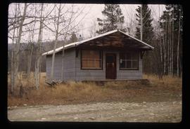
Image depicts a small, abandoned house in Woodpecker, B.C.
Image depicts an aerial view of what appears to be a small farm, possibly in the McGregor Canyon.
Image depicts the location of a slump type of landslide at Moose Heights, north of Quesnel, B.C.
Image depicts an aerial view of a section of land, likely near the Fraser River, that is possibly either a slump or part of a mining operation. The slide is labelled "slump or mining."
Image depicts what is likely a slump slide at an unknown location.
Image depicts an unknown individual standing near what is most likely a slump slide at an uncertain location.
Image depicts two unknown individuals standing near what is most likely a slump slide at an uncertain location.
Image depicts an unknown individual standing next to what appears to be a slump type of landslide at an unknown location.
Image depicts a slug on the forest floor somewhere on Haida Gwaii.
Image depicts a few unknown individuals canoeing in a slough area while on approach to Bowron Lake.
Image depicts a slough area while on approach to Bowron Lake.
Image depicts the slopes of Tabor Mountain in Prince George, B.C.
Image depicts the sky at either dusk or dawn, from an unknown location.
Image depicts numerous skiers cross-country skiing on a trail through trees on the Birchleg Ski route on Tabor Mountain in Prince George, B.C.
Image depicts numerous skiers on the Birchleg Ski route on Tabor Mountain in Prince George, B.C.
Image depicts numerous skiers and skis that are standing upright in in the snow on Tabor Mountain in Prince George, B.C.
Image depicts a vehicle and a large group of skiers somewhere on Tabor Mountain in Prince George, B.C.
Image depicts a skier in a costume with a fake sword, somewhere on the Birchleg Ski route on Tabor Mountain in Prince George, B.C.
Image depicts the community of Skidegate on Haida Gwaii.
Image depicts two unidentified individuals examining a tractor meant to delimb trees. It is located in Prince George, B.C.
Image depicts the Skeena River somewhere near Prince Rupert, B.C.
Image depicts the Skeena River, as well as a stretch of highway that appears to be under construction.
Image depicts the Skeena River at Hazelton, B.C.
Image depicts the Skeena River.
Image depicts two totem poles in Skeena Crossing, B.C.
Image depicts Skeena Crossing, B.C.
Image depicts the Skeena River at Hazelton, B.C.
Image depicts the bus depot in Skagway, Alaska (USA).
Image depicts the old railroad building in Skagway, Alaska.
Image depicts a pair of mannequins in the second story windows of a building, possibly located in Skagway, Alaska.
Image depicts one of the main streets, Broadway, in Skagway, Alaska.
File contains slides depicting places around and between Skagway, on the Alaska border, Atlin and Miles Canyon.
Image depicts railway tracks and buildings with a beehive burner on the left. The location is likely Sinclair Mills, B.C. Map coordinates 54°01'17.4"N 121°40'53.0"W
Photograph depicts the Sinclair Mills community hall, it includes a sign in front of the building reading "Welcome to Sinclair Mills, Community Hall".
Image depicts a beehive burner covered in snow in Sinclair Mills, B.C. Map coordinates 54°01'17.4"N 121°40'53.0"W
File consists of photographs depicting Sinclair Mills and Quesnelle Forks, among other possibly locations. Photographs were likely taken by Kent Sedgwick while he was on personal trips.
Image depicts layers of silt along the Chilako River near Blackwater Road, Prince George, B.C.
Image depicts a vehicled parked on the side of the road, with a view of the coast of Haida Gwaii in the background.