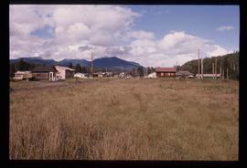
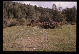
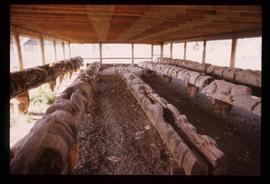
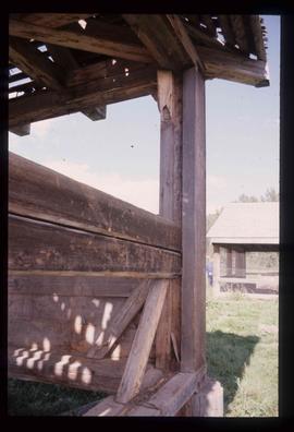
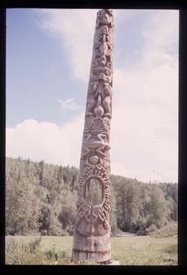
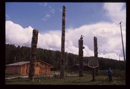
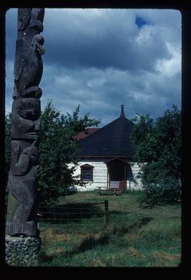
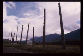
Image depicts numerous totem poles in Kispiox, B.C.
Image depicts the mouth of the Kispiox River.
Image depicts the Kiteen River at Dragon Lake near Aiyansh, B.C.
Image depicts a view of the area surrounding Kitimat, with power-lines in the foreground the city partially visible in the distance.
Image depicts what is possibly the Alcan smelter in Kitimat, B.C.
Image depicts numerous docked boats, as well as many houses on the shore in the background; located in Kitimat, B.C.
Image depicts several buildings in Kitimat, with the Bay being the tall one on the left.
Image depicts numerous businesses, such as the Bay, Overwaitea, and Dairy Queen, somewhere in Kitimat, B.C.
Image depicts numerous docked boats in Kitimat, B.C.
Image depicts a harbour in Kitimat, B.C.
Image depicts the interior of a mall somewhere in Kitimat, B.C.
Image depicts a man holding two fish on a dock in Kitimat, B.C.
Image depicts a row of houses somewhere in Kitimat, B.C.
Image depicts a view of the forest and lake around Kitimat, B.C.
Image depicts numerous individuals passing in front of the Bay in Kitimat, B.C.
Image depicts an Anglican church in Kitwancool Lake, B.C.
Image depicts an old, collapsing log building in Kitwancool, B.C.
Image depicts the interior of an old, collapsing log building in Kitwancool, B.C.
Image depicts numerous houses in Kitwancool, B.C.
Image depicts two old, overgrown and collapsing buildings, as well as a metal frame; it is located somewhere in Kitwancool, B.C.
Image depicts several old totem poles on their sides in Kitwancool, B.c.
Image depicts a shed somewhere in Kitwancool Lake, B.C.
Image depicts a totem pole in Kitwancool, B.C.
Image depicts a row of totem poles in Kitwancool, B.C.
Image depicts an Anglican church and a bell tower in Kitwanga.
Image depicts the CN Rail station located in Kitwanga, B.C.
Image depicts an old Hudson Bay Company house, with a totem pole in the foreground, in Kitwanga, B.C.
Image depicts an old Hudson Bay Company house in Kitwanga, B.C.
Image depicts a totem pole in Kitwanga, B.C.
Image depicts a row of totem poles in Kitwanga, B.C.
Photograph depicts KLM Engineering Ltd. at 1924 3rd Avenue. Annotation on verso: "KLM c-7, Native Head Start program?".
Image depicts a Knox United Church at an uncertain location, though possibly in either Hixon or Woodpecker, B.C.
Image depicts the historical village of 'Ksan near Hazelton, B.C.
Image depicts the 'Ksan historical village in Hazelton, B.C.
Image depicts the historical village of 'Ksan in Hazelton, B.C.
Image depicts a group of people in the historical village of 'Ksan near Hazelton, B.C.
Image depicts the entrance to the historical village of 'Ksan in Hazelton, B.C.
Image depicts a large gathering of people in the interior of a First Nations' longhouse located in the historical village of 'Ksan in Hazelton, B.C.
Image depicts a totem pole in the historical village of 'Ksan near Hazelton, B.C.
Image depicts the Kwinitsa CNR station in Kwinitsa, along the Skeena River.
Image depicts the Kwinitsa CNR station, which is Prince Rupert's railway museum.
Image depicts the La Tienda Hair and Nail Salon on an uncertain street somewhere in Prince George, B.C.
Image depicts the Lajoie Dam on the Bridge River, upstream side, showing part of Downton Lake and, in the foreground, the spillway intake.
Image depicts the Lajoie Dam on the Bridge River from the upstream side.
Image depicts the Lajoie hydroelectric generating station at the Lajoie Dam on the Bridge River (view of powerhouse and tailrace from top of dam).
Image depicts a lake with numerous buildings along the shore. The location is uncertain.
Image depicts a lake with lily pads somewhere on Haida Gwaii.
Image depicts a lake with a "Swim at Own Risk" sign at an uncertain location.