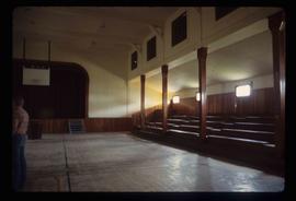
Image depicts the Catholic Church in Penny, B.C.
Image depicts Cayoosh Creek.
Image depicts Cayoosh Creek from a bridge in Cayoosh Valley.
Image depicts a bridge over Cayoosh Creek.
Image depicts a view of the scenery surrounding Cayoosh Creek.
Image depicts a view of Cayoosh Valley.
Image depicts a view of Cayoosh Valley. Cayoosh Creek is visible in the bottom left corner of the image.
Image depicts Cayoosh Valley.
Image depicts a mountain side in Cayoosh Valley.
Image depicts a road in Cayoosh Valley.
Photograph depicts Celia M Dusseau's grave stone in the Soda Creek Cemetery.
Image depicts an individual crouching in an old cemetery located somewhere in the coastal forest on Haida Gwaii, B.C.
Image depicts the Barkerville Cemetery.
Image depicts a cemetery at an uncertain location, possibly in Fort St. James, B.C.
Image depicts the Centennial Hall in Wells, B.C.
Image depicts the interior of the Centennial Hall in Wells, B.C.
Image depicts the Central Business District of Prince George looking north from Connaught Hill. Map coordinates 53°54'41.4"N 122°44'58.5"W
Image depicts 3rd Ave at Victoria St. Map coordinates 53°55'03.9"N 122°44'54.8"W
Image depicts an old, boarded up school, possibly the Central Fort George Traditional School in Prince George, B.C.
Image depicts Central Street West, parallel to Highway 97 in Prince George, B.C. looking north. Shown: Prince George Motors and other car dealerships, Burger King, Grama's Inn, and the Spruceland Shopping Mall sign. Map coordinates 53°54'42.1"N 122°46'53.1"W
Image depicts a snowman drawn on the chalkboard of what appears to be an unused school, possibly in Lamming Mills, B.C. The slide is labelled "note board school."
Image depicts a chasm full of trees at an unknown location.
Image depicts the wall of a chasm full of trees at an unknown location.
Image depicts the Cheslatta Falls.
Image depicts what appears to be a tour group at Cheslatta.
Image depicts the Cheslatta River.
Image depicts an old, and seemingly incomplete chess set somewhere in Wells, B.C.
Image depicts a view of Chetwynd, possibly from Highway 97.
Image depicts a Chevron station as well as two motels in Chetwynd, B.C.
Image depicts a view of some farm land in Chetwynd, B.C.
Image depicts several houses in Chetwynd, B.C.
Image depicts several businesses in a small section of Chetwynd, B.C. There is a motor hotel and a half-visible sign for an Esso gas station.
Image depicts a view of a saw mill in Chetwynd, B.C.