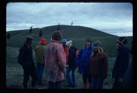
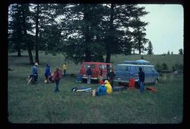
Print preview Close

Showing 3172 results

Archival description
3024 results with digital objects Show results with digital objects
Group of Hikers
2012.13.1.65.08 · Item · May 1975
Part of J. Kent Sedgwick fonds

Image depicts a group of people and two vans, apparently preparing to set out on a hike somewhere near Riske Creek, B.C.

Group of Hikers
2012.13.1.65.12 · Item · May 1975
Part of J. Kent Sedgwick fonds

Image depicts a group of hikers listening to a man, possibly a guide, speak. The location is possibly near Riske Creek, B.C.

Group and a Bus
2012.13.1.93.34 · Item · 1978
Part of J. Kent Sedgwick fonds

Image depicts a group of individuals and a bus with words that read: "Prince George Limousine & Charter." The river in the background is possibly the Peace River, and the location is possibly somewhere near Fort St. John, B.C.

Grooving
2012.13.1.124.11 · Item · June 1975
Part of J. Kent Sedgwick fonds

Image depicts an aerial view of a grooved region of land at an uncertain location.

Grooving
2012.13.1.124.12 · Item · June 1975
Part of J. Kent Sedgwick fonds

Image depicts an aerial view of a grooved region of land at an uncertain location.

Grooving
2012.13.1.124.13 · Item · June 1975
Part of J. Kent Sedgwick fonds

Image depicts an aerial view of a grooved region of land at an uncertain location.

Grooving
2012.13.1.65.40 · Item · June 1975
Part of J. Kent Sedgwick fonds

Image depicts an aerial view of grooves in the land near the Fraser River, possibly caused by glaciers.

Grooving
2012.13.1.65.42 · Item · June 1975
Part of J. Kent Sedgwick fonds

Image depicts a view of grooves in the land near the Fraser River, possibly caused by glaciers.

Grooves
2012.13.1.124.14 · Item · June 1975
Part of J. Kent Sedgwick fonds

Image depicts an aerial view of a grooved region of land at an uncertain location.

Gravel
2012.13.1.124.18 · Item · Oct. 1975
Part of J. Kent Sedgwick fonds

Image depicts layers of gravel at the BCR site in Prince George, B.C.

Gravel
2012.13.1.124.19 · Item · Oct. 1975
Part of J. Kent Sedgwick fonds

Image depicts layers of gravel at the BCR site in Prince George, B.C.

Granduc Townsite
2012.13.1.83.04 · Item · 1979
Part of J. Kent Sedgwick fonds

Image depicts a row of houses in Granduc, near the Granduc Mine and located north of Stewart, B.C.

Grain Elevator and Dock
2012.13.1.77.35 · Item · 1980
Part of J. Kent Sedgwick fonds

Image depicts a large vessel docked at a grain elevator and two smaller boats at a dock in the foreground somewhere in Prince Rupert, B.C.

Grade?
2012.13.1.41.05 · Item · 2002
Part of J. Kent Sedgwick fonds

Image depicts a clearing through the woods, possibly an abandoned grade for the BCR. It is possibly located on Iron Road South, near Woodpecker B.C.

Grade?
2012.13.1.41.07 · Item · 2002
Part of J. Kent Sedgwick fonds

Image depicts a clearing through the woods, possibly an abandoned grade for the BCR. It is possibly located on Iron Road South, near Woodpecker B.C.

Giscome Street Scene
2012.13.1.87.173 · Item · [between 1975 and 1995]
Part of J. Kent Sedgwick fonds

Image depicts a street in Giscome B.C. The Giscome Store is located on the left side of the image with the church in the background. Map coordinates 54°04'18.5"N 122°21'57.7"W

Giscome Station
2012.13.1.6.034 · Item · May 1975
Part of J. Kent Sedgwick fonds

Image depicts the old Giscome Train Station in Giscome, B.C. It was demolished between 1976 and 1977.

Giscome School - Before
2012.13.1.87.084 · Item · [between 1980 and 2000?]
Part of J. Kent Sedgwick fonds

Image depicts the Giscome mill site in Giscome, B.C. The bunkhouse is in the background on the left and the school is in the foreground on the right. Map coordinates 54°04'04.8"N 122°22'04.7"W

Giscome School - After
2012.13.1.87.085 · Item · [between 1975 and 1995]
Part of J. Kent Sedgwick fonds

Image depicts the Giscome mill site in Giscome, B.C. The bunkhouse is no longer there and the school is in the foreground on the right. Map coordinates 54°04'04.8"N 122°22'04.7"W

Giscome Sawmill
2012.13.1.87.167 · Item · [between 1975 and 1995]
Part of J. Kent Sedgwick fonds

Image depicts the mill site at Giscome, B.C. Map coordinates 54°04'19.7"N 122°22'04.7"W

Giscome Sawmill
2012.13.1.87.171 · Item · [between 1975 and 1995]
Part of J. Kent Sedgwick fonds

Image depicts the mill site at Giscome, B.C. A sign in the foreground reads "Maynard's Industrial Auctioneers." Map coordinates 54°04'19.7"N 122°22'04.7"W