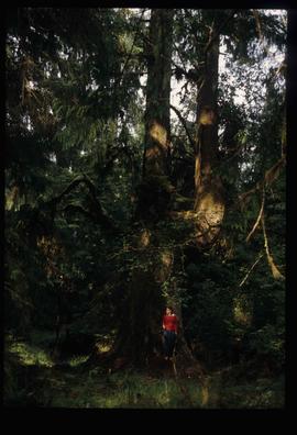
Image depicts an individual ducking under a tree branch somewhere in Haida Gwaii, B.C.
Image depicts an individual, possibly Sue Sedgwick, standing next to a very thick and tall tree somewhere on Haida Gwaii.
Photograph depicts people sitting on chairs in a circle in a backyard.
Image depicts a group of people on the rocky bank of a river somewhere near Mt. Robson.
Image depicts a group of people standing on the foot of a glacier, possibly the Robson Glacier.
Image depicts several unidentified individuals standing on a bridge; it possibly crosses the peace River.
Image depicts a group of people observing splintered wooden boards at an uncertain location.
Image depicts a group of people standing on a hill, with what is possibly Mt. Robson in the background.
Image depicts a group of unknown individuals with a mountain in the background.
Image depicts a man talking to a group of hikers, with what is possibly Mt. Robson and the Robson Glacier in the background.
Image depicts a group of people heading towards a glacier, possibly the Robson Glacier.
Image depicts several unidentified individuals and a bridge behind them; it is possibly crossing the Peace River.
Image depicts the community hall in Penny, B.C.
Image depicts the CN Station in Penny B.C. A woman, possibly Sue Sedgwick, is sitting against the outside wall.
Image depicts the CN Station in Penny B.C.
Image depicts a railway crossing sign with peeling and cracked paint somewhere in or near Penny, B.C.
Image depicts the post office in Penny, B.C.
Image depicts Sue Sedgwick standing in front of an old, run-down house somewhere in or near Penny, B.C.
Image depicts two signs for hiking trails in Penny, B.C. One reads: "Hiking trail to Red Mt. Lake (Grizzly Bear Mt.) expect to meet wild animals."
Image depicts four unidentified individuals standing on the bank of a river, possibly the Fraser, somewhere in or near Penny, B.C.
Image depicts a river, possibly the Fraser, near Penny, B.C.
Image depicts a red boat on a river, possibly the Fraser, near Penny, B.C.
Image depicts a beehive burner somewhere in or near Penny, B.C.
Image depicts the condominiums in the "Pemberton Valley Estates" in Pemberton, B.C.
Image depicts rail road tracks and several buildings in Pemberton, B.C.
Image depicts a view of Peden Hill in Prince George, B.C.
Image depicts the Pearson Homestead.
Image depicts a section of forest located somewhere in the Peace River Regional District of B.C.
Image depicts grass burning at an uncertain location in the Peace River Region.
Image depicts a street of shops at an uncertain location somewhere in the Peace River Regional District. A pink and blue building, possibly a theatre, is labelled "Lux."
Image depicts the W.A.C. Bennett Dam on the Peace River in Hudson's Hope, B.C.
Image depicts a large group of unidentified individuals sitting on a hill; what is possibly the Peace River is visible in the background.
Image depicts what is possibly the Peace River running next to some farm land at an uncertain location.
Image depicts a dam and a reservoir of water, possibly on the Peace River.
Image depicts a dam, possibly on the Peace River.
Image depicts a dam on what is possibly the Peace River.
Image depicts the Peace River, possibly near Clayhurst or Hudson's Hope, B.C.
Image depicts what is possibly the Peace River.
Image depicts a river, possibly the Peace River.
Image depicts what is possibly the Peace River running parallel to a road, possibly Highway 29.
Image depicts the Peace River.
Image depicts the Peace River, possibly near Hudson's Hope, B.C.