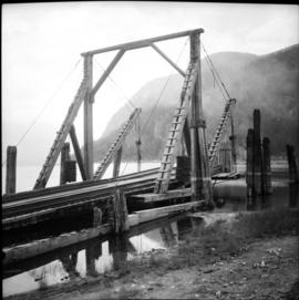
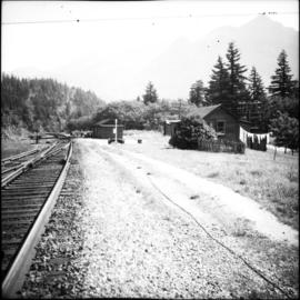
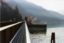
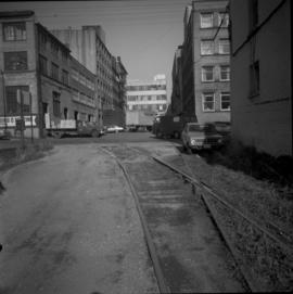
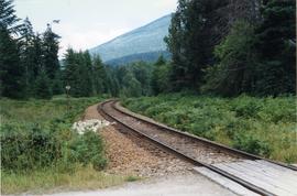
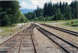
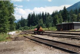
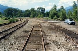
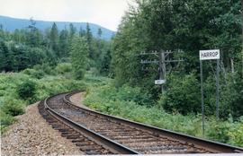
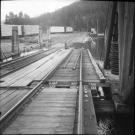
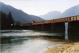
Photograph depicts a barge apron on Slocan Lake. Looking south along branch line which runs 31 miles to south Slocan junction.
Photograph depicts a barge apron at end of branch line on Slocan Lake. The lake service connects with Roseberg for Nakusp.
Photograph depicts the CPR at the Huntingdon/Sumas border (BC/Washington State border). A Mission way freight train is standing at about 5 pm, ready to return to Mission. The photo shows CP caboose #436733, built in 1920 out of wood. The border is about 10 ft. behind the camera.
Photograph depicts the CPR at North Bend in the Fraser Canyon. The yard is obscured by the trees to the right of the hut to the right of the train set. The view is looking north.
Photograph depicts the CPR at Harrison Mills. It is at mile 68.1 from North Bend and about 8 miles west of Agassiz. The depot has long since been removed. The nearest cabin was manned, presumably by the bridge tender/swing span operator of the bridge. Immediately behind the photo spans the Harrison River. The swing span carries a double track and is interlocked.
Photograph depicts the CPR at Haig, B.C. It is at mile 40.1 from North Bend. Since about 1970 it has ceased to exist as it no longer appears in the staff timetables. Prior to the building of the road/rail bridge at Hope in 1916/1917 it was the closest depot to Hope, which was reached by ferry. The road to the former ferry dips down on the right of the photo behind the clothes lines. The view is looking northeast.
Photograph depicts the CPR at Coutlee, about 2 miles west of Merritt at the Village of Lower Nicola. It is believed to be known as the Merritt Mine Spur, as it is a loading point for ore mined some few miles away to the north. The view is looking east.
File consists of material regarding saltwater rail ferries in British Columbia run by the Canadian Pacific Railway and the Canadian National Railway. Predominantly consists of photocopy reproductions, excerpts from books, and clippings from periodicals. Includes the following works:
Postcard depicts CPR and CNR bridges at Cisco-Fraser River, Canyon, BC
Photograph taken at the Clayborn diamond crossing. The CPR runs north and south while the BC Hydro Railway crossing northwest and southeast. An interlocking hut is found at the upper left of the diamond crossing.
File consists of an original CPR Alberta, Revelstoke, and Vancouver Divisions timetable 87 (26 Apr. 1992). Also includes Supplement No. 1 to Time Table No. 87.
File consists of a 45" record containing an advertisement for CP Rail entitled "Steel Wheel". Side B contains the French version of the advertisement, entitled "Grands Horizons".
Postcard depicts CPR #5800 at Cambie, BC with a loaded coal train headed for Roberts Bank, BC.
Subseries consists of material regarding the main line of the Canadian Pacific Railway in British Columbia, which runs from the Alberta border to Vancouver, from 1900 to the present. Includes information about branches from the main line, such as the Arrow Lakes branch, Okanagan branch, Mission branch, and New Westminster branch.
Subseries consists of general material regarding the Canadian Pacific Railway in both Canada and British Columbia. Includes information about the history of CPR, chronologies, statistics, CPR management and administration, and publicity. Also includes monographs relating to CPR.
Subseries consists of research material regarding the early days of the Canadian Pacific Railway in British Columbia, between 1880 and 1900. Includes information about the construction of the CPR main line in British Columbia, the Chinese labour force used in the construction of the railway, and tunneling through the Canadian Rockies.
File consists of documentary photographs taken by David Davies of the CPR line in Castlegar, British Columbia.
Subseries consists of information about areas served by the Canadian Pacific Railway in British Columbia, including Metro Vancouver. Contains material regarding the Nakusp & Slocan branch, Kaslo & Slocan branch, Crows Nest Pass Railway, and other minor lines.
Photograph depicts CP/KVR trackae at the south end of the station in Summerland. The switch was put in by the restoration society. It was not there in CPR days.
Photograph depicts CPR way freight and caboose on CN trackage between Lumby and Vernon, travelling to Vernon.
Photograph depicts what Davies noted to be a rare sight to be on a train. Visible are CPR way freight between Lumby and Vernon, travelling to Vernon. 31 of them built at CPR Angus shops in 1976. Only 10 survived at the beginning of 1997.
Photograph depicts a CPR swing bridge in Harrison Mills. Looking east, towards Kilby Store. Swing section in the foreground. It was rarely used.
Photograph depicts a CPR swing bridge in Harrison Mills. Taken on the downstream side of Harrison River.
Photograph depicts a CPR swing bridge in Harrison Mills. Looking west, on the upstream side of the Harrison River.
Photograph depicts a swing bridge in Harrison Mills. It was rarely used, but all its controls were modern and maintained.
Photograph depicts CPR service flanger #400572 at Cranbrook. It was built in 1930.
Photograph depicts the CP rail track beside Burrard Inlet, approximately parallel with Simon Fraser University. It shows the rear view of the eastbound "Canadian" at about 7 pm.
Photograph depicts the CP rail in the False Creek area in Vancouver. It is between Beatty and Cambie Streets with Smithe St. crossing from left to right in the foreground. The photo includes an insulated box car of the Southern Pacific Railway, #SP 67343, built in 1961. The track at the right is physically usable but is unused.
Photograph depicts CP rail interchange yards about 1/2 mile west of the city center of New Westminster. In the view is CP baggage car #272046 made by the Canadian Car Co. It is now in use as a horse box with end loading.
File consists of an original copy of CP Rail's "General Operating Instructions", CS44.
Photograph depicts the Hatzic Meadows crossing, east of Mission City in the Fraser Valley. It shows the westbound C.P. rail express running at 50-60 mph.
Photograph depicts the CP rail and the edge of the Homer St. warehouse complex in Vancouver. The view is looking northeast at the western end of Mainland St. The building is at #1152 Mainland St. The right hand track (man's shadow it) goes down Mainland and is in apparent use. The rail on the left hand track is dated 1938.
Photograph depicts the C.P. pier in Vancouver. The ship "Chusan" is unloading cargo.
Photograph taken 20 miles east of Nelson at the Nelson Subdivision (Cranbrook to Nelson). The white substance near the track was a crude fill of some kind. Location was somewhere between Procter and Harrop.
File consists of documentary photographs taken by David Davies of the Procter-Harrop area of the CPR Nelson Subdivision in British Columbia.
Photograph depicts the CPR Nelson Subdivision in Procter. Located at a third of a mile spur to a barge slip. Its beginning is visible as a former switch site.
Photograph depicts the Nelson Subdivision in Procter. Until 1977, the rail/barge slip was used for lake traffic. All related facilities were removed. Track to slip located on the left. Rails were on existing spurs dated between 1898 and 1914.
Photograph depicts the CPR Nelson Subdivision in Procter. Passing siding rail dated 1954 as well as 1923. All Algoma Steel. The two spurs to the right usually only held work trains and ore rail of 1898-1914 vintage.
Photograph depicts the CPR Nelson Subdivision in Harrop.
File consists of documentary photographs taken by David Davies of the CP Main Line in Vancouver, British Columbia.
File consists of documentary photographs taken by David Davies of the CP Main Line in all areas, except Vancouver, in British Columbia.
File consists of documentary photographs taken by David Davies of CPR Kettle Valley Railway line from Princeton to Penticton in British Columbia.
File consists of documentary photographs taken by David Davies of the CP Kettle Valley Railway from Penticton to McCulloch in British Columbia.
File consists of documentary photographs taken by David Davies of the CP Kettle Valley Railway from Merritt to Princeton in British Columbia.
File consists of documentary photographs taken by David Davies of the CP Kettle Valley Railway-Coquihalla branch in British Columbia.
Photograph depicts the switcher in Grand Forks. When CPR abandoned this city on KYR, there was a need for local switching to BN branch line, so a private company was created. 10 of these switchers were built in 1950/51 for the CPR. This particular locomotive retured in 1989 and was sold to GFR in 1993.
Photograph depicts a fuel storage shed in Harrison Mills.
Photograph depicts CPR delivering 4 tank cars at an interchange track on Home Street. Kamloops Heritage Railways was commencing to build its facilities on the north side of the interchange track.
File consists of documentary photographs taken by David Davies of the CPR branch from Sicamous to Vernon in British Columbia.