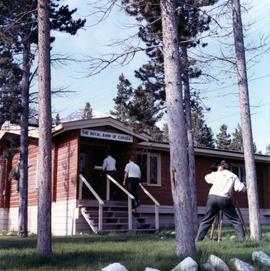
Photograph depicts two unidentified men entering building with the sign "THE ROYAL BANK OF CANADA" above main entrance. Photographer with tripod in foreground.
Photograph depicts plant buildings below, tailings pile in foreground. Valley and mountains in background. Handwritten annotation on recto of photograph: "CASSIAR".
Photograph depicts plant buildings in front of tailings pile in midground. Forest, power line, and tramline in foreground; south mountains in background.
Photograph depicts mine valley and road in foreground. Cassiar plant and tailings pile visible in left midground, townsite in right midground. Mountainside of McDame Mountain in foreground, southern mountain range in background.
Photograph depicts the West Peak of the Cassiar mine on McDame Mountain. Pit area visible between West Peak and road in foreground. Mine valley and north mountain range in background. Photo speculated to have been taken from a point on or near the South or North Peak.
Photograph depicts crusher plant in centre foreground. Shifter shack and vehicles can be seen in front of pit area. West Peak semi-visible in right midground. Mine valley an northwestern mountain range in background.
Photograph depicts a ridge showing asbestos fibers.
Photos of rocky ridge and hill of potential Asbestos project.
Photograph depicts a geologist's hammer, believed to belong to Cassiar's Chief Geologist Bill Plumb. The hammer provides a scale for the exposed asbestos, indicating the percent of fibre in the rock as well as the expectation of grade.
Photograph depicts Cassiar employees and two firemen wearing Justice Institute of British Columbia hats standing in front of an open garage with fire trucks in Vancouver.
Photograph depicts a group of men and women touring inside the mill.
Photograph depicts a group of peaople gathered outside for a building dedication.
Photograph appears to be a close up of fibre samples. Title of original file implies a relation to Grizzley Sizer equipment.
Photograph depicts close up view of gravel pit, ruler displayed for scale. Photograph speculated to have been taken at the plant or near the Cassiar airstrip. Stamped annotation on recto of photograph: "JUN. 1987".
Photograph depicts lab technician Gloria Dostie in the mill lab.
Photograph depicts glacier on McDame Creek road, 1.5 miles from the mine at Cassiar. Snow-covered trees in background.
Photograph depicts McDame Creek Road, snow-covered and taken from center of road 1.5 miles from the early construction camp at Cassiar. Two stakes in foreground, one on either side of road. Glacier is believed to be crossing road between two stakes. Trees on either side of road, trees and hills in background.
Photograph depicts Gile Chartrand in the surface shop.
Photograph depicts underground mine superintendent Gerald Verret.
Photograph depicts planned maintenance supervisor Gerald Currie sitting at a desk with a computer.
The file contains eight photographs depicting close up images of three rock samples, some photographed with a ruler for scale. One of the rock samples is speculated to be obsidian and the other two are likely serpentine. The images where originally found in an envelope titled "ROCKS" and are likely dated around 1991.
Included in this file are an five photographs of rocks on a shelf, which may be asbestos sample rocks. There are five accompanying negatives to these photographs and are likely dated around 1977. The photographs and negatives were found in an envelope labelled "Negatives - CIMM Photos."
Additionally two negative strips of geology maps of Canada. These negatives were found in an envelope labelled "Negatives - CIMM Papers, Mining, Planning, Geology."
File includes six aggregations of photographs which have been assembled in this file in order to maintain the integrity of each group by keeping the photos arranged together, though each group features operations pertaining to multiple files in this subseries. Includes groups featuring photos from 1961, 1965 1971, a helicopter trip, a community album, and a workplace album. Photographs depict images pertaining to the following operations at Cassiar, B.C.: mining, milling, maintenance, labratory tests, and tramline and town operations. Images featuring operations of the company town include the grocery store, bank, churches, school, library, lounge, pool, theater, community center, outdoor recreation, hospital, dentist, cafeteria, bus route, residences, air strip, firehall, laundromat, park, police, and newspaper.
An assortment of photographs speculated to have been used for research purposes as Cassiar administration established the mine and the town.
Subseries consists of photographic material pertaining to the following subject areas: mine operations; plant operations;labour strike 1970s images; townsite operations of the company towns of Cassiar and Clinton Creek (including community activities associated therein and townsite development); as well as, images of mines not owned by Cassiar Asbestos Corporation, but which are believed to have been used for operational research purposes.
Photograph depicts Gary Pederson driving a truck in the equipment garage.
Handwritten annotation on recto of photograph: "FURNACE PAD AUG 25/64." Photograph depicts construction worker standing on elevated wood platform. Three other men can be seen working in construction area. This location is believed to be under the conveyor to crusher building, retaining wall in midground.
Photograph depicts two men standing to left of Fred Murray on balcony of large building or structure speculated to be in the Cassiar valley. Portion of log structure in left foreground, man and hauling trucks on road in background.
Handwritten annotation on recto of photograph: "FORMING FOOTING RETAINING WALL JULY 4/64." Photograph depicts construction workers
standing in forms for cement laid against mountain wall on high elevation of construction site. A retaining structure made with wood planks and rebar separates mountainside dirt from cement forms. A front end loader can be seen in midground, near unidentified building. Mountain range in background.
Photograph depicts forklifts carrying pallets of asbestos onto a ship at the Cassiar asbestos wharf.
Photograph depicts a forklift test using a pallet of packaged asbestos.
Photograph depicts a forklift and an asbestos unit viewed from above.
Handwritten annotation on recto of photograph: "FORMING FOOTING FOR TRANSFORMER HOUSE AUG 20/64." Photograph depicts construction workers standing in forms made of wood and rebar for cement footings. Lumber scattered throughout, mountain range in background.
Photograph collection of various foothills around Cassiar.
Photograph depicts range of hills, clouds in background.
Photograph depicts hill, trees in foreground.
Photograph depicts range of hills, trees at base.
Photograph depicts range of hills, trees in valley.
Photograph depicts range of hills. Trees in valley, clouds in background.
Photograph depicts range of hills, trees in valleys.