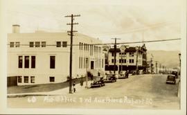
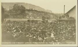
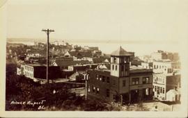
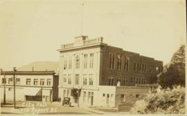
Postcard featuring a car parked outside of Prince Rupert City Hall. Handwritten annotation on verso reads: "Alex Hall, Glyn P.O., Victoria, B.C. Prince Rupert, Billy S."
Publication is entitled "Prince Rupert Bulk Loading Facility: Phase 2 Environmental Assessment of Alternatives" by the Northcoast Environmental Analysis Team.
Image depicts a view of what is possibly a shipping yard in Prince Rupert, B.C. The slide is labelled "superport."
Image depicts the rail yards in Prince Rupert.
Image depicts an old building on the main street of Prince Rupert, B.C. Only half of the business name is visible: "Skeena Color [sic]."
Image depicts the main street of Prince Rupert, B.C.
Image depicts numerous houses on the cliff-sides in Prince Rupert, B.C.
Image depicts numerous houses in Prince Rupert, B.C.
Image depicts several houses in Prince Rupert, B.C.
Image depicts numerous houses in Prince Rupert, B.C.
Image depicts numerous buildings and a small dock somewhere in Prince Rupert, B.C. One of the buildings is labelled "Fishermen's Supply."
Image depicts a view of the downtown core of Prince Rupert, B.C.
Image depicts the City Hall of Prince Rupert, B.C.
Image depicts the Bank of Nova Scotia located on "Besner Block" in Prince Rupert, B.C.
Image depicts a view of Prince Rupert, B.C.
Photograph depicts silhouette of Prince Rupert BC buildings and the view looking beyond to the water.
Image depicts the interior of the Pride O' the North shopping mall in Prince Rupert, B.C.
Image depicts the Pride O' the North shopping mall in Prince Rupert, B.C.
Photograph depicts Premier Peter Lougheed talking with unidentified men at the Crest Hotel in Prince Rupert during Campagnolo's Skeena Riding tour. Campagnolo stands behind Lougheed. Several unidentified people talk behind them.
Photograph depicts Premier Peter Lougheed and an unidentified man sitting at a table and talking at the Crest Hotel in Prince Rupert during Campagnolo's Skeena Riding tour. An unidentified group of people sit a table behind them.
Colour-coded map depicting surveyed lands respectively open and closed to preemption. Depicts land recording divisions, land district boundaries, government reserves, communities, bodies of water, and transport routes. Includes topographical inset.
Street view of Third Avenue in Prince Rupert. Printed annotation on recto reads: "60 Post office 3rd Ave Prince Rupert BC."
Photograph of post office and neighbouring building. Both buildings are composed of wood and tent materials. Annotation on recto reads: "Post Office & Customs House, Prince Rupert, BC."
Violet stands second from left among group of six girls wearing uniforms, posed in front of backdrop. Two sit on floor, and four stand behind their coach, who is seated in a chair and wearing a suit. A basketball sits between his feet, painted with "COMETS 1921-1922". Violet's shirt has a letter "C" on its front. This photograph was taken in Prince Rupert where Violet attended high school while living with her relatives Sarah and Herbert Glassey.
Photograph of a young girl believed to be Katy Collison seated for a formal portrait on a wheeled chair. Handwritten annotation in pen on recto reads: "With love from 'Mama'[?] 1907." Handwritten address on verso reads: "Miss West[?] Metlakatla British Columbia N.W. America." Two half penny stamps affixed on verso and partially obscured by two postmarks which read: "Folkstone 1.15 PM SP 19 07."
Photograph depicts three men wearing semi-formal attire at doorway to log building, miscellaneous supplies leaning against base of building. Dirt road in foreground, forest trees on hillside in background. Handwritten annotation on verso of photograph reads: "Mile 47 B.C. Police Barracks.", on recto of photograph: "Summit of Yellowhead pass and east boundary of British Columbia Mile 0. 699 miles to Prince Rupert. Tete Jaune Mile 52. Mile 47 east of Tete Jaune in the Park.", "1911".
Image depicts an old theatre owned by Paul Aivazoff in Prince Rupert, B.C. It opened in 1935 and was closed in 1981; it has since been renovated for retail use.
Overhead view of a block of business and harbour buildings in Prince Rupert BC. The "Savoy Hotel" is visible in the foreground. Printed annotation on recto reads: "Part of Business Section & Harbour. Prince Rupert B.C. F. Button Photo Pr. Rupert No. 494."
Photograph of several floats parading down Second Avenue in Prince Rupert. A large crowd is gathered. Annotation on recto reads: "Photo by MacRae Bros Prince Rupert BC Prince Rupert B."
Part of a set of 41 original black & white photographs [1908-1933-?]) of the Grand Trunk Pacific Railway line in BC depicting surveying crews, town sites (Prince Rupert and its port, Hazelton and Fort George), and First Nations Peoples.
Postcard overview of several identifiable storefronts built amongst the rocky outcrops of Prince Rupert. Printed annotation on recto reads: "Prince Rupert BC."
Elevated street view of Fulton Street in Prince Rupert, BC. City Hall is in the left foreground. Hills and water are visible in the background. Printed annotation on recto reads: "Prince Rupert. B.C."
Part of a set of 41 original black & white photographs [1908-1933-?]) of the Grand Trunk Pacific Railway line in BC depicting surveying crews, town sites (Prince Rupert and its port, Hazelton and Fort George), and First Nations Peoples.
Slightly overhead shot of a large crowd gathered by general store and railroad. Annotation on recto reads: "Overseas contingent leaving Prince Rupert BC Feb 26th 1915. McRae Bros."
Photograph depicts a view looking down on the buildings of the city of Prince Rupert BC and beyond to the harbor and mountains in the distance.
Overhead view of a residential area in Prince Rupert, BC. Printed annotation on recto reads: "Prince Rupert, BC Photo by J.W."
Wide angle photograph of many buildings scattered in a clear cut area. Foreground shows several businesses, including "Kelly Carruther's Supply" and "Prince Rupert Hardware and Supply Co." Some remaining forest is visible in the background. Annotation on recto reads: "Prince Rupert, BC 1659."
Overhead view of many commercial buildings in Prince Rupert, BC. Printed annotation reads: "Prince Rupert, BC."
Photograph depicts Otto Lang, Minister of Transport, with two unknown men during his visit to the Fairview Cargo Terminal in Prince Rupert.
Photograph depicts Otto Lang, Minister of Transport, talking with a reporter outdoors during his visit to Prince Rupert Fairview Cargo Terminal.
Photograph depicts Otto Lang, Minister of Transport, being videotaped while talking to a reporter with a microphone during his visit to Prince Rupert Fairview Cargo Terminal.
Photograph depicts Otto Lang, Minister of Transport, talking to a reporter with a microphone during his visit to Prince Rupert Fairview Cargo Terminal.
Photograph depicts Otto Lang, Minister of Transport, being videotaped with two unknown men during his visit to the Fairview Cargo Terminal in Prince Rupert.
Photograph depicts Otto Lang, Minister of Transport, speaking with two unknown men during his visit to the Fairview Cargo Terminal in Prince Rupert.
Photograph depicts Otto Lang, Minister of Transport, and an unknown man walking on the Fairview Cargo Terminal in Prince Rupert.