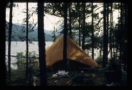
Image depicts a camp on the shore of a lake in South Tweedsmuir Provincial Park. The man sitting in the bottom right corner is possibly Kent Sedgwick.
Image depicts a group of individuals at camp somewhere in Mt. Robson Provincial Park.
Image depicts a cabin at an uncertain location.
Image depicts the welcome sign in Burns Lake, B.C.
Image depicts a stretch of road somewhere at Burns Lake, B.C.
Image depicts Burns Lake, B.C.
Image depicts bunkhouse, restaurant and store in Sinclair Mills, B.C. Map coordinates 54°01'17.4"N 121°40'53.0"W
Image depicts the upper end of the Bullion Pit in Likely, B.C.
Image depicts an old, half-collapsed house in Likely, B.C.. The slide labels it as "Bullion house."
Image depicts a stretch of road through the Bulkley Valley.
Image depicts a section of forest in the Bulkley Valley.
Image depicts a view of Bulkley Valley.
Image depicts the Bulkley River near Moricetown, B.C.
Image depicts numerous unknown individuals standing by the Bulkley River near Moricetown, B.C.
Image depicts a small group of people standing near the Bulkley River at Moricetown, B.C.
Image depicts the Bulkley River.
Image depicts a row of buildings in Upper Fraser, B.C. with the store (titled "Paradise") with a Pepsi sign. Map coordinates 54°07'09.1"N 121°56'47.0"W
Image depicts several old buildings in a field, one of which has a caved-in roof, in Newlands, B.C. Map coordinates 54°06'28.2"N 122°12'01.0"W
Image depicts numerous buildings and a dock on the shore of Haida Gwaii, B.C..
Image depicts a vehicle parked beside a small, wooden house in Upper Fraser, B.C. Map coordinates 54°07'05.7"N 121°56'38.9"W
Image depicts an old building, possibly located at the closed Britannia Mine.
Image depicts the Bridge River No. 1 hydroelectric station on the shore of Seton Lake (rear side of powerhouse).
Image depicts the Bridge River near Lillooet, B.C.
Image depicts a river in Tumbler Ridge, B.C. The bridge crossing it appears to be either half-missing or incomplete.
Image depicts a bridge under construction in Tumbler Ridge, B.C.
Image depicts a bridge in Prince George, B.C.
Image depicts the old sales office of Bralorne Pioneer Mines Ltd. which is now the Bralorne Pioneer Museum.
Image depicts what is possibly an old, rundown mill in Bralorne, B.C.
Image depicts a row of houses in Bralorne, B.C.
Image depicts several houses in Bralorne, B.C.
Image depicts a few boarded-up buildings in Bralorne, B.C.
Image depicts a church and a row of houses in Bralorne, B.C.
Image depicts Bralorne, B.C.
Image depicts an area of Barlone, B.C. surrounded by trees.
Image depicts what appears to be a log jam on what is possibly the Bowron River. The slide is simply labelled "Bowron Canyon."
Image depicts what is possibly the Bowron River from a bridge. The slide is simply labelled "Bowron Canyon."
Image depicts what is possibly the Bowron River. The slide is simply labelled "Bowron Canyon."
Image depicts several boats on what appears to be a river, and an old beehive burner in Penny, B.C.
Image depicts a group of people in boats, with Ray Mueller steering one of them, on the Fraser River in the Grand Canyon, B.C.
Image depicts a group of people in boats on the Fraser River in the Grand Canyon, B.C.
Image depicts a boat docked inside what appears to be a type of boathouse, possibly located in Metlakatla near Prince Rupert, B.C.