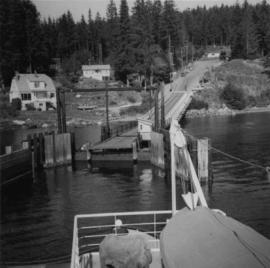
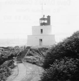
Photograph depicts the last lighthouse on the mainlain about a mile south of Ucuelet. It was believed to be the Amphitrite Point Light House.
File consists of research material regarding VIA Rail's link with Amtrak, connecting Vancouver, BC with Seattle and Portland. Predominantly consists of photocopy reproductions, excerpts from books, and clippings from periodicals. Includes Amtrak schedules for the Seattle/Vancouver route, "By Train to Seattle, Again: The Inaugural of the Mount Baker International" by Nicklason; and "Safe at any Speed: Amtrak asks FRA for Talgo Waiver".
Photograph depicts one of the entries in the Nanaimo-Vancouver Bath Tub Race. Thre were 2112 entires and there was 32 mile crossing. Only 46 reached the finish line, of which this was one.
Photograph depicts an old anchor that had been fished out of Coal Habour, Vancouver. One flulke was bent in towards the shank. Image captured outside the office of Kanata Marine Ways Ltd. (1965).
File consists of research material regarding issues with animals on railway tracks, which predominantly consist of photocopy reproductions, excerpts from books, and clippings from periodicals. Includes incidents involving elephants, moose, cattle, snakes, bears, elk, dogs, beavers, ospreys, and others.
Photograph depicts the annual Bath-Tub Race that took place in Nanaimo. Visible is a competitor preparing for the start. There were 106 entries in that year.
Photograph depicts the annual Bath-Tub Race that took place in Nanaimo. Visible are rescue and patrol boats that were about to set out.
File consists of ten annual reports of the Railway Department of the Province of British Columbia for the years 1946-1950, 1953-1954, 1956-1958.
Photograph depicts the ferry from Campbell River approaching the Quathiaski Cove slip on Quadra Island.
Photograph depicts the 1966 Armistice Day Parade at Victory Square, Vancouver. An RCMP detachment is found on the east side of the square. Looking north on Cambie Street.
Postcard depicts Albert Canyon.
Photograph taken on the CNR Okanagan Branch, Mile 21, east of a tunnel near Monte Creek. Dated 1938. Captured at the base of a deep embankment that may have resulted from a washout.
Postcard depicts the summit of the Selkirk Range. Board in the right foreground says "Rogers Pass 1 Mile."
Photograph depicts a boom tug called "Atlas Captain" that was brought in for refitting, adjacent to a smalll boat repair yard. It was loaded on a CN gondola car and then removed by a derrick crane.
File consists of research material regarding automobile carriers. Predominantly consists of photocopy reproductions, excerpts from books, and clippings from periodicals.
Photograph depicts an auto special at New Westminster, travelling west to McPherson Ave. industrial estate in south Burnaby.
Photograph depicts avenger torpedo bombers that were purchased in 1958 and were owned by Skyway Air Sevices of the Abbotsford Airport. There were 14 avengers owned at the time the photograph was taken.
Photograph depicts a wood and fabric AVRO 504K fighter, built in 1919. It was first developed in Britain in 1913. Now powered by Clerget Rotary. The fighter was used by the RCAF as a biplane trainer until 1928. This type was also used as crop duster, stunt machines, etc.
Photograph depicts an AVRO 504K fighter and biplane rainer of the RCAF, dated 1919.
Photograph depicts a baby seal at C.N. log drop at Cowichan Lake on Vancouver Island.
File consists of material regarding baggage and express services for rail passengers. Predominantly consists of photocopy reproductions, excerpts from books, and clippings from periodicals. Includes information regarding baggage wagons, freight weight rates, freight houses, and the Canadian Pacific Express Company.
Photograph taken at the defunct Okanagan Landing which was a rail/water transfer point from 1892 to 1940. A buggage trolley from the site still existed.
Photograph depicts ballast cars at Squamish, near government wharves and chemical plant. They were built by the Western Wheeled Scrapper Co. in Aurora, Illinois and do not have a date.
Photograph depicts a ballast packing machine found at the CN Kamloops Junction.
Photograph depicts part of a ballast removal and cleaning special train at the CN Kamloops Junction.
Photograph depicts a ballast wagon awaiting demolition at repair shed of the B.C. Electric Railway in New Westminster. The car was built in 1948.
Photograph depicts ballasting re-laid new track at the Pacific Great Eastern yards in North Vancouver, beside the Vancouver Wharves Ltd.
Photograph depicts a bandstand at English Bay in Vancouver, B.C.
Photograph taken on the Banks and Vernonia tourist rail line in Oregon.
Photograph taken at Barkerville.
Photograph depicts a barn at Darfield, near Barriere, about 35 miles north of Kamloops. The English timbered cottage developed from this architectural form.
Photograph depicts a barn of the Glenwalker Ranch. Built in 1890-1910.
Photograph depicts a barn at Lund, a village 12 miles north of Powell River. This building overlooks the harbour.
Photograph depicts a barn at Port Guichon, 1 mile west of Ladner, Delta.
Photograph depicts a barn attached to Watch Lake Lodge, a dude ranch.
Photograph depicts a barn located in Aspen Grove.
Photograph depicts a barn advertised for rent on Liverpool Rd. in South Westminster. Barn later half demolished on April 17, 1966.
Photograph depicts a barn in the Upper Fraser Valley, west of the Vedder crossing and southwest of Atchelitz.
Photograph depicts a barn located on the south side of Kokamee Creek, part of Kootenay Lake.
Photograph depicts an unusual style of barrier to a private house.
Photograph depicts bascule bridges in the inner harbour of Victoria. Property of EN. In the process of being repaired and painted.
File consists of documents relating to railway construction in general and railway construction statistics, which predominantly consist of photocopy reproductions from books and clippings from periodicals. Includes the following items, among others: "Historical Summary of Railways in British Columbia" (BC Rail Guide No. 1) by Davies and Nicklason; "Dismantling the GNR tracks within B.C." compiled by Davies; "Summary of Route Mileages built in B.C. in Decades to 1930" compiled by Davies; "Rail Distances in B.C." compiled by Davies; and "A Chronology of Railways of B.C." by Dave Wilkie.
Photograph depicts the Department of Highways ferry named "Nimpkish" that was based in Port McNeill. It maintained a frequent daily triangle run, that travelled from Port McNiell to Sointula, then to Alert Bay. It held a capacity for 16 cars and 150 passengers.
Photograph depicts B.C. Electric ballast car #3013 standing on the new industrial siding on the northeast side of the Langley depot.
Photograph depicts the B.C. Electric rail bridge crossing the north section of the north arm of the Fraser River from Vancouver to Mitchell Island. The span is always kept open except for rail traffic.
Photograph depicts the B.C Electric rail bridge crossing the south section of the north arm of the Fraser River. The view is looking north from Mitchell Island, which takes steel traffic to and from the Western Canada Steel Ltd.
File consists of documentary photographs taken by David Davies of the B.C.E.R. in British Columbia.
File consists of documentary photographs taken by David Davies of the BC Electric Railway on Granvile Island, Vancouver.
Photograph depicts a view looking northeast of the B.C. Electric Railway from the abandoned Sumas substation at Vedder Mountain.