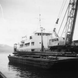
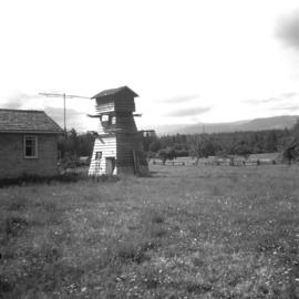
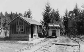
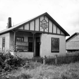
Photograph depicts the Provincial Government Mine Rescue Station established in 1913 in Nanaimo, B.C. It is in the south side of the city.
Photograph taken at Tahsis Ltd. Tree Farm, crossing the Muchalt River on a public logging road that went from Gold River to Woss Lake. The road took the heaviest trafiic which included logging trucks and semi trailers bound for the end of the island as it was the only route by land.
Photograph depicts a public logging road that crossed over the Muchalat River. The bridge was disused and blocked off. Photograph taken at the Tahsis Tree Farm Ltd.
Photograph depicts a Public Weigh Scale that was operated in Vancouver, on Main Street, opposite the CN Depot.
Photograph depicts the Public Works Department dredger (suction) at work in the north arm of the Fraser River, near Boundary River, in Vancouver.
Photograph depicts the P.W.D. dredger at work in the north arm of the Fraser River in Vancouver.
Photograph depicts a Public Works Department vessel, "Essington II." It was fitted with a crane and used for snag removing, buoy work and light pile driving. Here, it was shown with the barge alongside it.
Photograph depicts a pump car at the Fort Steele Railway Museum. Pump car made by Sylvester Manufacturing Co. Ltd., Linsay, Ontario. Two men were needed in order to make one full revolution of the crank.
Photograph depicts a pump car that was property of Kamloops Heritage Railway. Viewed at the downtown CNR station in Kamloops.
Photograph depicts a pump house on the Island Highway, north of Qualicum Beach, Vancouver Island.
Photograph depicts the "Queen of Powell River" built in 1965. B.C. Ferry Authority loading at Earls Cove for Saltery Bay (Powell River).
Photograph depicts the "Queen of the Islands" of B.C. Ferries, approaching the pier at the Long Harbour Terminal on the Gulf Islands. It was launched in 1963 and built by Burard Dry Dock Company Ltd. It had a capacity for 40 cars and 400 passengers.
Photograph depicts the "Queen of the Islands" of B.C. Ferries, located at the slip of the Long Harbour Terminal on the Gulf Islands.
Photograph depicts railway track previously owned by BCER. It led onto the east end of Lulu Island and then to Annacis Island. Looking from the Naew West River Walk to the Queensborough bridge that was protected by signals and had a high chain link fence to deter pedestrians. It was likely that the rail was only used at night. Originally built by Canadian Northern Railway to reach Steveston, circa 1917.
Photograph depicts a RAF Avro Vulcan Bomber that flew from Britain directly to BC for the Centennial International Airshow with a fuelling stop at Gander. The bomber was first introduced in 1952 and was built by AV Roe and Co. Manchester.
Photograph depicts a view looking northeast down a rail and road lane at the west end of Homer St. in Vancouver. It shows CP box car #296105 with end loading doors, built in November 1951. The car was empty. The rail in this area is dated 1911.
Photograph depicts the rail at the end of a disused "Y", with both arms removed. This is at the CPR McCulloch depot located at mile 76.6 on the Carmi Subdivision. The rails are Canada Algoma, 85 lbs., and dated 1918 or 1919. There is room for two locomotives and a caboose to turn. The view is looking east.
Photograph depicts the trackage [main passing track?] at the McCulloch CPR depot, located at mile 76.6 on the Carmi Subdivision. The rail is 85 lbs. and dated 1940.
Photograph depicts a disused rail barge slip on the south side of Vancouver harbour, just east of Campbell Ave. and leading off the Canadian National Railway (CN) and Great Northern Railway (GNR)trackage coming for the False Creek yards. The view is looking north.
Photograph depicts a rail bridge.
Photograph depicts a rail bridge carrying the C.N.R. track over the Thompson River at Lytton, BCThe bridge is at the confluence of Fraser River and Thompson River. View looking north.
Photograph depicts a railcar and possible shed or depot. Location and details unknown.
Photograph depicts rail cars in Vancouver, B.C.
Photograph depicts the rail on the CPR line near Okanagan Falls, within a quarter mile of the Okanagan Falls depots to the north. The rail is on the main line of the branch and is in daily use. It is located at approximately mile 10.2 from Penticton.
Photograph depicts rail on the CPR main line at Okanagan Falls, within a quarter mile north of the Okanagan Falls depot buildings. The line is in daily use and this portion is at about mile 10.2 from Penticton. The trackage was built here in 1931.
Photograph depicts the rail on the CPR line near Okanagan Falls, within a quarter mile of the Okanagan Falls depots to the north. The rail is on the main line of the branch and is in daily use. It is located at approximately mile 10.2 from Penticton. The trackage was built here in 1931.
Photograph depicts a rail yard. Location and information unknown.
Photograph depicts service car #409780 in the CPR Penticton yard. The car had no building date.
Photograph depicts the railway bridge at New Westminster, looking towards the south bank. The bridge is used by C.N., BCHydro, and the Great Northern Railway.
Photograph depicts the famous 'loops' that used to gain and lose height from Princeton Valley.
Photograph depicts the curves of the famous 'loops' that used to gain and lose height from Princeton Valley.
Photograph depicts the water end view of 5 sets of ramps used for drawing storm wheelers out of the water by moving them up horizontally to the beach. There was no evidence of recent use.
Photograph depicts a ranch at the upper and east end of Nicola Lake, 20 miles northeast of Merritt. It has a steam traction engine and thresher, last used agriculturally about 10 years ago. Steamed and moved in 1964 for C.B.C.
Photograph depicts an RCAF Langer that was erected in 1942 as part of a flying boat base to counter possible Japanese sea and activities. It was used subsequently as whaling station premises.
Photograph depicts a RCMP motor patrol launch, #53 found at Granges Harbour, Salt Spring Island, Gulf Islands.
Photograph depicts RCN "Restigouche," a destroyer escort that was fitted to eliminate submarines. It towed a 7 ton sonar pod and had 8 torpedoes that were launched by rockets. It was first initiated in 1954. Canada, at the time, had 4 ships of this class.
Photograph depicts the R.C.N. tribal class destroyer entering the Esquimalt Harbour, looking seawards.
Photograph depicts a reaction ferry at Blackpool, near Clearwater on the north Thompson River, about 60 miles north of Kamloops. The car is being loaded on the east bank.
Photograph depicts a reaction ferry at Blackpool, near Clearwater on the north Thompson River, about 65 miles north of Kamloops. At least 3 such ferries exist north of Kamloops. In freshet the trip takes 1 minute, in low water 15-20 minutes. The other two ferries are equipped with outboard motors in 1964. The ferry broke loose in flood water in approximately 1960.
Photograph depicts a reaction ferry over the Fraser River, located just north of Lytton. The east bank leads to the Lytton-Lillooet road, while the west bank is a dead-end road 20 miles long along the river shelf.
Photograph depicts a reconstructed wagon at a Surrey gas station.
Photograph depicts an all steel refrigerated car in the CPR yard in Penticton.
Photograph depicts relocated and relaid trackage that served a sawmill located at Lakeshore and Bay Street, at the north end of downtown Kelowna.The rail approach was then via Weddell. Two spurs on the left took chip cars while the two spurs on the right were for box cars filled with finished products.
Photograph depicts the first train to move over the remade track after a derailment in Savona.
Photograph depicts the remains of 2-8-2 Baldwin locomotive #101 at the Rayonier Railroad camp, north of Hoquiam in Washington. It was built in 1913, weighs 70 1/2 tons and has 27, 000 lbs. of tractive effort. It is on the scrapping line at the central depot.
Photograph depicts the remains of a sawmill located at the north end of Trout Lake. Stone work in the foreground was built upon a log raft and had heavy machinery secured to its top.
Photograph depicts the possible remains of a WWII armoured personell carrier that belonged to a used machinery firm that was soon vacating due to land clearance.