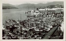
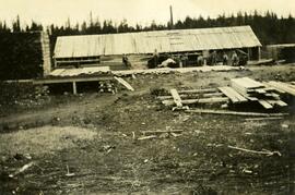
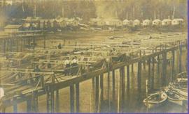
View of dock full of rows of nets and a few workers. Sail boats are anchored near the dock and there are rows of bunkhouses in the mid ground, trees in the background. Handwritten annotation in pencil on recto reads: “Port Essington B. C.”
Photograph of a large dock littered evidence of lumber transportation. Small buildings and stumps are on the shoreline. Annotation on recto reads: "Prince Rupert BC, '07."
Photograph depicts dog seated on grass in foreground. Unidentified individuals visible below with fishing nets in waterfall area at Moricetown Canyon.
Photograph depicts a Dorosz Tool Company tri-cone rock bit on a Prince Rupert pamphlet.
Photograph depicts unknown man driving bulldozer on edge of mine area at high elevation. The dozer is an International model TD24 (manufactured between 1947 and 1955). A second man stands on edge of cliff, directing driver. Expansive mountain range in background.
Photograph depicts unknown man driving bulldozer on edge of mine area at high elevation. Mine road can be seen below leading to Cassiar plant in background on left, townsite visible on right. South mountain range in distance. Handwritten annotation on verso of photograph: "1961".
Photograph depicts horse logging.
File contains photographs depicting close view of drill bits used in the Cassiar mine. The photos were taken for documentary purposes during an evaluation procedure in which the bits were tested and compared. 32 of the photos are adhered to three reports containing detailed analysis of the condition and function of the drill bits used. Reports were addressed to "E. Komperdo / Assist. Mine Superintendent, Production," and were sent by "Bob Clark / Industrial Engineer" and "E. Isaaks / Engineer Trainee." All of the photos are heavily annotated on verso and recto, often documenting the date, bit number, drilling depth, and notes on general condition.
Photograph of Ingersoll-Rand machinery drilling in the early days of the Cassiar Pit.
Photograph depicts buildings visible through clearing in trees. Water crosses foreground, hills visible in background.
Handwritten annotation on verso reads: "Dry dock / Prince Rupert B.C."
Photograph depicts large dry rock storage building on left, mill in background, dryer building on far right. Road and power poles cross foreground, mountains stand in background. Photo caption next to printed copy of image in 1953 Annual Report: "Completed dry rock storage and dryer buildings."
Photograph depicts large dry rock storage building in foreground on left, mill in background, dryer building in right midground. Miscellaneous supplies in far right foreground, mountains visible in background. Handwritten annotation on verso of photograph: "Sept 1954". This photograph was originally stored inside duotang labeled "CASSIAR ASBESTOS CORPORATION LIMITED PHOTOGRAPHS 1954"; photo caption beneath this image: "40,000 Ton Dry Storage Building / Mill / Dryer Building".
Photograph depicts large dry rock storage building in foreground on right, mill on left behind tailings pile, and dryer building in centre behind conveyor belt connecting mill to dry rock storage. A cloud can be seen rising from plantsite. Trees and Troutline Creek cross foreground, mine valley and mountains visible in background. Stamped annotation on recto of photograph: "ANSCO PRINTON Munshaw Colour Service Ltd. MAR 10 1955".
Photograph depicts red truck dumping waste at what is believed to be the tailings pile at the Cassiar plant. Small building and unidentified individual in bottom left foreground, valley and mountains in background. Photo caption next to printed copy of image in 1953 Annual Report: "Stockpile of 80,000 tons of Ore at Mill."
Photograph depicts dump truck under power lines and tramlines on gravel road. Buckets hang on line, mountains in background.
Overview of sawmill situated in valley. Finished lumber visible in distance.
Image depicts the site of Giscome's first quarry, with Eaglet Lake located in the foreground.
Image depicts the site of Giscome's first quarry, with a train passing by and Eaglet Lake located in the foreground.
Photograph depicts a donkey engine at the Cowichan Valley Forest Museum
Photograph depicts the North peak of McDame mountain in the earlier stages of strip mining, South peak unmined in background. Quonset and other shops visible in left foreground, unknown building built into mountainside in right foreground.
Photograph depicts wood houses behind stand of trees in Cassiar valley. Truck, power poles, and road in foreground, mountains in background. Typed caption below photo in original duotang album: "Two Bedroom Pan-Abode Houses - Cassiar Townsite". Handwritten annotation on verso: "Sept 1954".
Photograph depicts an early type of spool donkey circa 1890-1900, on display at Promised Land Park on the Olympia Peninsula in Washington state.
Photograph depicts an early type of steam donkey mounted on a flatcar and attached to a Shay Tank. It is displayed on the roadside at Promised Land Park, probably near Forks, on the Olympic Peninsula in Washington state.
Hills on opposite shore in background.
Handwritten annotation on verso reads: "Early steamship off mouth of Nass River".
Photograph depicts unidentified individual and cars on street in foreground, snow banks, trees, and power poles on either side. Buildings can be seen on far right, mountains visible in background. Handwritten annotation on recto of photograph: "townsite Looking East".
Sign in foreground reads: “Stop Bull Shitting, [Phoney (crossed out)] Ioney”.
Handwritten annotation on verso reads: “The Kitimat Oil Port Environmental Lobby, didn’t believe I killed it. I did!”
Semi-visible sign reads: “Supertanks - Pipelines S.O.S.”
Photograph depicts crowd with individuals holding protest signs.
Photograph of lab equipment at plantsite. It is believed the equipment depicted was involved in fibre testing.
Item is a photograph of Finlay Forks trader Roy McGregor, pilot Ian Watt and British resource development designer Percy Gray in March 1957 after the first leg of Grey’s flight over the Rocky Mountain Trench.
Image depicts numerous tractors at Finning Tractor and Equipment Co. Ltd. located along Highway 97 in Prince George, B.C.
Head on shot of steam engine traveling through a pass with mountains in the background. Handwritten annotation in pen on verso reads: "First Passenger Engine to reach Prince Rupert." Annotation on recto reads: "First Passenger Engine at Prince Rupert." Photographer' stamp in bottom right corner of recto reads : "Allen Photo."
Pile driver situated on Prince Rupert shoreline. Tents and wooden buildings visible on rocky background. Printed annotations on recto of photograph read: "First pile driven at Prince Rupert BC. June 8 '06."
Photograph of a mustachioed man perched atop a cart load of lumber hitched to a team of horses. Annotation on recto reads: "First Team Hitched Up at Prince Rupert May 1908."
Photograph depicts a wooden flume funneling water in a forested area. Photo is adhered to paper backing, upon which handwritten annotation on recto reads: “First wash for gold by Hixon Creek Cariboo Gold Co. Across Hixon from Quesnel Quartz up the hill. North side of creek 1930’s”
Photograph depicts a wooden flume funneling water in a forested area. Photo is adhered to paper backing. Original annotations on verso of photo are covered by paper mounting. Typed annotation on recto of paper reads: “First wash for gold by Hixon Creek Cariboo Gold Co. Across Hixon from Quesnel Quartz up the hill. North side of creek 1930’s”
Photograph depicts two fisherman on a boat--one holding a crab trap and another looking at the catch.
Photograph depicts an unidentified fishing boat at the Prince Rupert marina. Several other fishing boats are visible in the background.
Photograph depicts an unidentified fishing boat at the Prince Rupert marina. An unidentified person stands beside a building in the far background.
Photograph of many fishing boats in a Prince Rupert harbour. Printed annotation on recto reads: "Fishing Boats Prince Rupert, BC Photo by J. Wrathall." Handwritten annotation on verso reads: "Greetings from British Columbia Ruth and Jim Warner[??]." Postcard is addressed to: "Mr. and Mrs. C. Ott 426 So. Humboldh Denver 9. Colorado U.S.A." Verso is affixed with a 4 cent Canadian stamp. Postmark reads: " Vancouver B.C. Canada. Jun 5 5 PM 1954."
Photograph of many fishing boats in a harbour. Printed annotation on recto reads: "Fishing Boats Unloading at Prince Rupert, B.C."
Tugboat appears to be towing a long line of small boats.
Handwritten annotation on verso reads: "Fishing fleet coming home Nass River B.C."
Photograph depicts two large metal structures on flatbed trailer. Trees visible in background.
Photograph depicts a floating log saw cutter moored in the north arm of the Fraser River on the Lulu Island side near the #8 road.
Image depicts numerous tree logs floating on a body of water. The location is uncertain, but is likely Eaglet Lake.
Image depicts several pieces of heavy machinery used in forestry. The Coast Inn of the North is seen in the background.
Image depicts an unidentified individual examining a piece of heavy machinery used in the forestry industry. It is located in Prince George, B.C.
Handwritten annotation on recto of photograph: "FORMING FOOTING RETAINING WALL JULY 4/64." Photograph depicts construction workers
standing in forms for cement laid against mountain wall on high elevation of construction site. A retaining structure made with wood planks and rebar separates mountainside dirt from cement forms. A front end loader can be seen in midground, near unidentified building. Mountain range in background.
Typed caption glued to album page directly below photograph reads: "27. Fort Fraser Sawmill." Photograph depicts men standing outside the Fort Fraser Sawmill. Photographer: Dominion Stock & Bond Corporation.