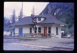
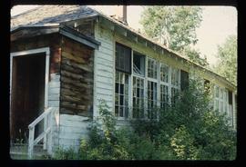
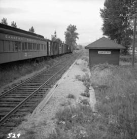
Photograph depicts Koksilah depot of the Esquimalt and Nanaimo Railway on Vancouver Island. It is 2 miles south of Duncan and the view is looking north.
Image depicts the historical village of 'Ksan near Hazelton, B.C.
Image depicts the 'Ksan historical village in Hazelton, B.C.
Image depicts the historical village of 'Ksan in Hazelton, B.C.
Image depicts a group of people in the historical village of 'Ksan near Hazelton, B.C.
Image depicts the entrance to the historical village of 'Ksan in Hazelton, B.C.
Image depicts a large gathering of people in the interior of a First Nations' longhouse located in the historical village of 'Ksan in Hazelton, B.C.
Image depicts a totem pole in the historical village of 'Ksan near Hazelton, B.C.
Image depicts the Kwinitsa CNR station in Kwinitsa, along the Skeena River.
Image depicts the Kwinitsa CNR station, which is Prince Rupert's railway museum.
Image depicts the La Tienda Hair and Nail Salon on an uncertain street somewhere in Prince George, B.C.
Image depicts the Lajoie Dam on the Bridge River, upstream side, showing part of Downton Lake and, in the foreground, the spillway intake.
Image depicts the Lajoie Dam on the Bridge River from the upstream side.
Image depicts the Lajoie hydroelectric generating station at the Lajoie Dam on the Bridge River (view of powerhouse and tailrace from top of dam).
Image depicts a lake with numerous buildings along the shore. The location is uncertain.
Image depicts a lake with lily pads somewhere on Haida Gwaii.
Image depicts a lake with a "Swim at Own Risk" sign at an uncertain location.
Image depicts a lake and a cabin at an uncertain location.
Image depicts the Lakeland Sawmill in Prince George, B.C, identified by the beehive burners; the one with white smoke belonged to Pas Lumber Co. which was bought out by Lakeland in 1987.
Image depicts the Lakeland Sawmill in Prince George, B.C.
Image depicts a boarded-up house in Lamming Mills, B.C.
Image depicts an old, boarded-up store/office in Lamming Mills, B.C.
Image depicts the old, boarded-up community hall in Lamming Mills, B.C.
Image depicts several boarded-up houses in Lamming Mills, B.C.
Image depicts several old houses and an old, yellow pick-up in Lamming Mills, B.C.
Image depicts what appears to be the old, abandoned mill in Lamming Mills, B.C.
Image depicts what appears to be a part of the old, abandoned mill in Lamming Mills, B.C.
Image depicts a Yellowhead Realty sign in Lamming Mills, B.C. It reads: "For Sale, entire community, 50 buildings, 60 acres."
Image depicts a small section of the area surrounding Lamming Mills, B.C.
Image depicts the old school building in Lamming Mills, B.C.
Landscape with stumps, and roadbed with small (railroad?) track in foreground. River crosses midground, trees and sky in background. Men can be seen standing on far right on raised roadbed.
Photograph depicts long bridge over river. Closest pier in left foreground, opposite shore in background.
Image depicts a large building with numerous vehicles in the foreground.
Photograph depicts a side view of a large building with a porch and a large yard.
Slightly elevated view of a large crowd gathered in a park during the winter in Prince Rupert, BC. They appear to be observing some sort of ceremony or event that is out of frame.
Image depicts a large group of people sitting and eating near a bridge at an uncertain location, though possibly near Hudson's Hope, B.C.
Photograph depicts a large group of people walking on a wooden pier with wooden houses in the background.
Photograph depicts a large unidentified house along the shoreline with a forested area in the background.
Photograph depicts a large house that was actually the Sunset Beach Lodge. The western end of the block was being demolished. Image captured the last complete block of houses on Beach Ave.
Image depicts a large saw at an indoor location, likely in a saw mill somewhere in Prince George, B.C.
Image depicts a piece of machinery shaped like a large metal cylinder. It is possibly located somewhere in Fort St. John, B.C.
View from of a large ship in dry dock surrounded by water. Printed annotation on recto reads: “G.T.P. Dry dock Prince Rupert B.C. McRae.”
Photograph depicts unidentified building with large wood beams in entryway.
Photograph depicts the last standing totem poles at Masset, B.C.
This blueprint shows the top-down (showing the plan view) and the side view (showing elevation) of the transfer station layout. The process and operation of the jig back discharge and monocable loading are also included. Relevant measurements and dimensions are included as well as locations of the loading chute, the loading area, monocable as well as empty and loaded rope lines.
Image depicts numerous boats docked by the Prince Rupert Fishermen's Co-operative Association from the deck of a ferry, possibly as it's leaving Prince Rupert, most likely for Haida Gwaii.
Image depicts several individuals seated on a ferry as it possibly departs from a dock somewhere in Prince Rupert, B.C. It is most likely headed for Haida Gwaii, B.C.
Exterior photograph of a residential school. Printed annotation on recto reads: “Industrial Indian school, Fraser Lake. B.C.
Image depicts the BCR station in Leo Creek, B.C.