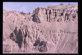
Showing 2118 results

Archival description
2097 results with digital objects Show results with digital objects
Dunlevy Creek?
2012.13.1.50.138 · Item · 2006
Part of J. Kent Sedgwick fonds

Image depicts the Dunlevy Creek area somewhere near Dawson Creek, B.C. The slide is simply labelled "Dunlevy irrigation" for uncertain reasons.

Dunlevy Creek?
2012.13.1.50.137 · Item · 2006
Part of J. Kent Sedgwick fonds

Image depicts the Dunlevy Creek area somewhere near Dawson Creek, B.C. The slide is simply labelled "Dunlevy irrigation" for uncertain reasons.

Eaglet Lake?
2012.13.1.87.082 · Item · [between 1975 and 1995]
Part of J. Kent Sedgwick fonds

Image depicts a lake at an uncertain location, likely Eaglet Lake.

Eaglet Lake Creek
2012.13.1.89.095 · Item · [1980?]
Part of J. Kent Sedgwick fonds

Image depicts the creek flowing into Eaglet Lake. A grey area of hill on the right side of the image appears to be the Giscome Quarry. Map coordinates 54°04'26.2"N 122°22'04.3"W

Eroding Rock Face?
2012.13.1.98.60 · Item · 1999
Part of J. Kent Sedgwick fonds

Image depicts what appears to be an eroding rock face. The slide itself is labelled "ash loger at top" for unknown reasons. Possibly located somewhere near Whitehorse, Y.T.

2012.13.1.121.07 · Item · July 1970
Part of J. Kent Sedgwick fonds

Image depicts an atmometer. According to the slide, it is being used for measuring the rate of water evaporation "from carborundum stone." The location is uncertain.

Examining a Rock
2012.13.1.91.38 · Item · 1979
Part of J. Kent Sedgwick fonds

Image depicts a group of individuals who appear to be examining a rock. It is possibly part of an educational trip.

Examining Rocks
2012.13.1.93.21 · Item · 1978
Part of J. Kent Sedgwick fonds

Image depicts three unidentified individuals examining rocks near a set of railway tracks at an uncertain location in the Peace River Region.

Farm
2012.13.1.50.067 · Item · 1978
Part of J. Kent Sedgwick fonds

Image depicts a farm on the west side of the Fraser, south of Quesnel, B.C.

Farm?
2012.13.1.50.111 · Item · 1980
Part of J. Kent Sedgwick fonds

Image depicts what appears to be a farm at an uncertain location.

Farm
2012.13.1.72.18 · Item · July 1981
Part of J. Kent Sedgwick fonds

Image depicts a farm at an uncertain location; possibly somewhere in the McGregor Valley.

Farm
2012.13.1.54.65 · Item · July 1980
Part of J. Kent Sedgwick fonds

Image depicts a farm at an uncertain location.

Fault?
2012.13.1.50.050 · Item · 1978
Part of J. Kent Sedgwick fonds

Image depicts an unknown individual standing next to what appears to be a fault at an unknown location.

Fault?
2012.13.1.50.054 · Item · 1978
Part of J. Kent Sedgwick fonds

Image depicts what appears to be a fault at an unknown location.

Felled Trees
2012.13.1.56.06 · Item · 1973
Part of J. Kent Sedgwick fonds

Image depicts a large number of felled trees, and an unknown individual standing on the path.

Fence
2012.13.1.12.18 · Item · Sep. 1983
Part of J. Kent Sedgwick fonds

Image depicts a fence, perhaps somewhere in the Chilcotin region.

Fence
2012.13.1.12.15 · Item · Dec. 1980
Part of J. Kent Sedgwick fonds

Image depicts a fence in the Blackwater River area in the Chilcotin.

Fence
2012.13.1.12.17 · Item · Sep. 1983
Part of J. Kent Sedgwick fonds

Image depicts a fence somewhere in Anahim Lake, B.C.

Fence
2012.13.1.12.16 · Item · Sep. 1983
Part of J. Kent Sedgwick fonds

Image depicts a fence somewhere in Anahim Lake, B.C.

Fence and Power Lines
2012.13.1.78.47 · Item · 1982
Part of J. Kent Sedgwick fonds

Image depicts a fence and power lines near the shore on Haida Gwaii. It is possibly a small community such as Masset.

Fenced Off Forest Area
2012.13.1.87.149 · Item · [between 1975 and 1995]
Part of J. Kent Sedgwick fonds

Image depicts two unidentified individuals standing outside a small, enclosed area somewhere in a forest. The location is uncertain.

Finish Line
2012.13.1.129.01 · Item · 1971
Part of J. Kent Sedgwick fonds

Image depicts numerous skiers standing near a finish line somewhere on Tabor Mountain in Prince George, B.C.

Fishing
2012.13.1.23.15 · Item · 1973
Part of J. Kent Sedgwick fonds

Image depicts two youths fishing from the bank of the Nechako River on Cottonwood Island.

Fishing
2012.13.1.84.39 · Item · 1994
Part of J. Kent Sedgwick fonds

Image depicts a few unidentified individuals fishing in a river at an uncertain location.

Fishing on McCleary Lake
2012.13.1.55.19 · Item · 1971
Part of J. Kent Sedgwick fonds

Image depicts two individuals fishing in a canoe on McCleary Lake. The slide is also labelled "dolly," likely meaning the fish in the net is a Dolly Varden trout.