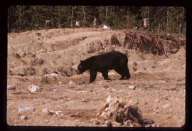
Image depicts a bear located at the Bear Lake Dump.
Image depicts the BCR tracks passing through a mill somewhere near the 100 Mile.
File contains slides depicting views of numerous B.C. Mountains.
Image depicts the Battle Hill National Historic Site in Kitwanga, B.C.. The sign located there says: "The small knoll in the valley was a native fortress. Legends maintain that it was man-made: built to repel marauding coastal tribes. The hill was the scene of local tribal battles, and at one time was crowned with the defenders' buildings. Known as Dhawdezp, the unique mound is a prominent feature in the legends and history of the Indian people."
Image depicts a basalt landform somewhere in or near Quesnel, B.C.
Image depicts a section of river located somewhere near Barriere, B.C.
Image depicts an old barn and a collapsing cabin somewhere in the Fort George Canyon Provincial Park, B.C.
Image depicts an old barn somewhere in the Fort George Canyon Provincial Park, B.C.
Image depicts a Hydraulic Placer mining location in Barkerville which has been completely deforested.
Image depicts a snow-covered hill in Barkerville, B.C.
Image depicts a forest of bare trees, possibly somewhere near Fort St. John, B.C.
Image depicts numerous logs that have been stripped of their bark at a saw mill in Prince George, B.C.
Image depicts a back road at an uncertain location, possibly near Iron Road North, north of Woodpecker, B.C.
Image depicts a boat on Babine Lake, taken from Granisle, B.C.
Image depicts Babine Lake.
Image depicts several unknown individuals on the shore of Babine Lake.
Image depicts two unknown individuals pulling a canoe through Babcock Lake's three mile creek.
Image depicts a glacier at an uncertain location; the slide is labelled "before."
Image depicts a glacier at an uncertain location; the slide is labelled "after two days," and shows how much it has melted.
Image depicts a glacier at an uncertain location; the slide labels it as "avalanche glac."
Image depicts a glacier on the side of a road at an uncertain location; the slide labels it as "avalanche glac."
Image depicts a glacier at an uncertain location; the slide labels it as "avalanche glac."
Image depicts a mountain somewhere along what is possibly the Atlin Road.
Image depicts what is possibly Atlin Road. Numerous mountains are visible in the distance.
Image depicts a mountain, possibly Atlin Mountain.
Image depicts what is possibly Atlin Lake, with numerous mountains in the distance and Atlin Mountain visible on the right of the image.
Image depicts Atlin Lake as well as a small section of Atlin, B.C. The mountain is possibly Atlin Mountain.
Image depicts Atlin Lake.
Image depicts the grave of John Wolters in the Atlin Cemetery. It reads: "Born in Kent, England, Jan 16 1857. Died Sept. 21 1905."
Image depicts the grave of John Elmwood Simons in the Atlin Cemetery. It reads: "died Feb. 8, 1914, age 61 yrs. froze to death."
Image depicts numerous graves in the Atlin Cemetery.
Image depicts the grave of Charley William Rudolf in the Atlin Cemetery. It reads: "Born July 2, 1923. Died May 21, 1940. Age 16 years. Died from gunshot wounds, mistaken for a bear."
Image depicts a boat named "the Tarahne," which is located in Atlin, B.C. Atlin Lake and Mountain are visible in the background.
Image depicts the post office in Atlin, B.C.
Image depicts an old boat on the shore of Atlin Lake.
Image depicts an old building undergoing a restoration process, possibly in Atlin, B.C.
Image depicts a dock on the shore of Atlin Lake, as well as a building that may have once been a hospital. The slide is simply labelled "hospital."
Image depicts numerous buildings on the shore of Haida Gwaii as the ferry approaches.
Image depicts what appears to be an apartment building among several others in an uncertain location.
Image depicts another train on the White Pass railway along a forested mountain side.
Image depicts what appears to be an animal pen in Island Cache. There is a goat and numerous chickens in the image, as well as a pile of miscellaneous material.
Image depicts a view of D'Arcy, located on the southern end of Anderson Lake.
Image depicts a vehicle on a bridge somewhere near Anderson Lake in the Seton Portage area.
Image depicts power lines running alongside Anderson Lake near Seton Portage, B.C.
Image depicts the Anderson Lake.
Image depicts a view of Anderson Lake near Seton Portage, B.C. A vehicle on a mountain road is also visible.
Image depicts a view of Anderson Lake near Seton Portage, B.C.