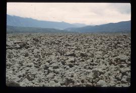
Photograph depicts the Cassiar plantsite in foreground, including the mill, dry rock storage building, tailings pile, and many other buildings. Townsite in midground, mountains in background. Handwritten annotation on recto of photograph: "Cassiar."
Photograph depicts the Cassiar valley. Handwritten annotation on verso of photograph: "1958 [1961 crossed through]", on recto: "Cassiar Asbestos Corporation Limited. Cassiar B.C. Townsite in foreground mill and ore storage in left middle ground," "Toronto set". It is believed that this photograph was made into a post card.
Photograph depicts tracks made by machinery in an earth road turning left in forest.
Image depicts a tractor with a claw lifting logs at a saw mill in Prince George, B.C.
File contains slides depicting a trail, and other areas, near Rossland, B.C.
Image depicts a patch of snow-covered ground with a sign that reads "Trail of 98," somewhere along the White Pass railway.
Photograph of a team of sled dogs pulling a load, followed by a group of men. Mountains are visible in the background. Printed annotation on recto reads: "Trail Over Bitter Creek Glacier to the Naas."
File contains 20 slides date stamped between July and August 1976 and annotated “TRAILER SERVICE SUMMER 1976", depicting the construction and renovation of a mobile home, excavations, and structures believed to be wells or water boxes. File also contains 9 additional slides with no annotations, depicting mobile home and houses in winter. These 9 images are associated with materials dated Nov. – Dec. 1976 and it is likely that these photographs were taken in the winter of 1975-1976.
Image depicts a train in an uncertain location, though it is possibly Howe Sound in the background.
Image depicts the side of a train and the tracks it is on, somewhere in the Seton Portage area.
Photograph of a train passing through a forested area.
Photograph of a train passing over a bridge near Stewart, BC. Printed annotation on recto reads: "103 Stewart BC."
Image depicts a train on the Hansard Bridge across the Fraser River looking west. Map coordinates 54°04'37.7"N 121°50'39.9"W
File contains photographs featuring the tramline at Cassiar which ran from the crushing plant at the mountain mine to the plantsite in the valley (a drop of 427 meters). The first ore was originally transported by truck to the plant until the gravity chute was built in 1953. This chute was replaced with the first aerial tramline model in 1956, which was succeeded by the second model in 1975. This file also includes one photo of the original gravity chute, and one photo depicting a tramline worker.
Additionally there is a collection of eighteen photographs of tramline cars that were being surveyed for damage and condition, and another collection of six photographs of tramline study. The results of this study determined that there was variances in load sizes of the buckets caused by extra material falling off the panfeeder.
File consists of a conference paper by Weller and Douglas C. Nord titled "Transborder Politics and Paradiplomacy: The Ontario-Minnesota Fishing Dispute." This file was originally numbered to correspond with conference paper number 51 listed in Weller's CV.
File consists of a conference paper by Weller titled "Transformational Planning in a University Setting: The Case of the University of Northern British Columbia." This file was originally numbered to correspond with conference paper number 85 listed in Weller's CV.
Al Elsey compiled his original footage from 1965 to produce this commercial film that deals with trapping beaver, the Anahim Lake Stampede and Caribou migration. The video provides a compilation of film footage shot by Elsey and is narrated by him describing the activities documented in the footage
Photograph depicts tree-covered mountain ranges in winter.
Image depicts two unidentified individuals examining a thick log still attached to the machine that cut it down. It is located somewhere in Prince George, B.C.
Item is a photograph of a large tree cutting machine.
Slide depicts cleared ground and felled trees in a forested area, likely at the Aleza Lake Experiment Station.
File contains a photocopied version of "Tree Farm Licence No. 29 - Eagle Lake Sawmills Ltd. Cutting Permit Application No. 7". Although this item is not related to the Aleza Lake Research Forest, it is relevant to forest history in the Prince George area and therefore retained by the Society.
Item is a photograph of a tree stump apparently eaten through by beavers.
Image depicts numerous trees in an uncertain location; the slide itself is labelled "T.T. Cutting," possibly meaning "Telegraph Trail Cutting."
Image depicts a few trees, with what is possibly the Northwood Pulpmill in the background, in Prince George, B.C.
Image depicts a small copse of trees boxed in by very small concrete barriers somewhere in Kettle Valley, B.C.
Bench visible in left foreground.
Image depicts a green car among some trees on Cottonwood Island.
Image depicts two old houses surrounded by numerous trees at an uncertain location.
Image depicts a stand of trees and a shed at Island Cache.
Image depicts a west-looking view of Trembleur Lake.
File consists of a paper by Michael Bradford entitled "Trends in the Abundance of Chinook Salmon of the Nechako River, British Columbia".
Footage of a pack train along a river, a campsite, view of the mountains, and two grouse.
Location is believed to be the Rainbow Mountains.
Image depicts a snow-covered cabin and a mountain in the distance. It is located somewhere near Birken, B.C.
Image depicts a mountain in the distance. It is located somewhere near Birken, B.C.
Image depicts numerous skiers at the cabin located at Troll Lake on Tabor Mountain in Prince George, B.C.
Item is a photograph of a truck hauling logs from the shores of a lake.
Photograph depicts men and haul trucks visible in distance on snowy road in tree-covered hills.
Image depicts truncated spurs somewhere near McBride, B.C.
Image depicts the Tseax Lava Flow.