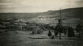
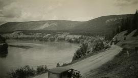
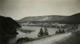
Photograph depicts a view of Fraser River from the Soda Creek hill in June 1936. Wyness notes that photograph was taken at mile 200, which was approximately 167 miles from Ashcroft.
Photograph depicts a view of Fraser River from the Soda Creek hill in October 1936. The town of Soda Creek is barely visible at right.
Photograph depicts a view of Front Street and Quesnel Hotel from Fraser River Bridge in Quesnel. Visible buildings include the Quesnel Hotel Cafe, the Quesnel Hotel, and John A. Fraser & Co. Ltd.
Photograph depicts a view of Hudson Bay Mountain taken from the Telkwa water tower. The Monckton survey crew tent, their car, and the railway track is also visible.
Photograph depicts a view of the city of Prince George looking west from the east hill. The confluence of the Fraser River and Nechako River is visible to the right. The Grand Trunk Pacific Railway bridge is visible at centre. The current location of where this photograph may have been taken is likely somewhere near where Highway 16 rises on the hill past the correctional centre (jail).
Photograph depicts a view of the town of Quesnel from a southeast hill. Fraser River and the Fraser River Bridge are visible at left, the Quesnel River at right.
Photograph depicts a view of the town of Telkwa, BC from the perspective of the Telkwa water tower.
Photograph depicts a view of the community of Williams Lake, taken from the Chilcotin Road to the west.