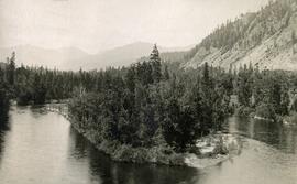
Image depicts a woman on a boat, possibly on War Lake.
Image depicts the old community hall located somewhere in the Wistaria Provincial Park.
Image depicts a river, possibly somewhere in the Wistaria Provincial Park.
Photograph depicts village buildings along shore.
Handwritten annotation on verso reads: "Massett in Winter dress."
Photograph depicts two people and a dog team on a snowy river bank with a narrow passage of open water and a snowy bluff in the background.
Elevated photograph of downtown Prince Rupert covered in snow. Printed annotation on recto reads: "Winter Scene. Prince Rupert. B.C."
Railroad track, utility poles, field, small building and background hills are visible in image.
Photograph depicts a four-dog team harnessed to a loaded sleigh. Two people stand near the loaded sleigh on a snowy forest path.
Photograph is a printed postcard depicting a few cabins covered in snow near Stewart B.C.
Image depicts a snowy street in Willow River, B.C. There are several buildings, one is an Esso station and another is labelled as "Red & White Food Store."
Image depicts a snowy street in Willow River, B.C. with a row of houses. The white building on the end with the Pepsi sign is the Willow River General Store. Map coordinates 54°04'18.3"N 122°28'14.7"W
Image depicts the Willow River General Store. Map coordinates 54°04'23.7"N 122°28'26.9"W
Image depicts a playground in Willow River, B.C. The slide labels it as being a "former hotel site." Map coordinates 54°04'23.7"N 122°28'26.9"W
Image depicts a group of people somewhere in Willow River, B.C. The man in the plaid shirt and beige cap is identified on the slide as being Lloyd Edwards.
Image depicts the cableway in Willow River, B.C.
Image depicts the cableway, stretching over a river, in Willow River, B.C.
Image depicts the cableway in Willow River, B.C.
Image depicts the St. Joseph's Mission in Williams Lake, B.C.
File contains slides depicting places in the area around Williams Lake, Clinton, and the Fraser Canyon.
Image depicts an aerial view of Williams Lake, B.C.
Image depicts a view of Williams Lake, B.C.
Image depicts an aerial view of Williams Lake, B.C.
Photograph depicts Wickaninnish Beach, north of Ucluelet on Vancouver Island.
Rock pile, unknown building, and hills can be seen in background.
Photograph is one of 11 images taken during a World Health Organization (WHO) trip, Human Rights of Women and Children, Peru, 1990. Possibly affiliated with World Council of Churches, International Ecumenical Delegation to Lima, Peru, 14-25 October 1990. See also items 2009.6.1.505 - 2009.6.1.515.
Trees in foreground, hills in background. Unidentified man stands on far left.
Photograph is one of 11 images taken during a World Health Organization (WHO) trip, Human Rights of Women and Children, Peru, 1990. Possibly affiliated with World Council of Churches, International Ecumenical Delegation to Lima, Peru, 14-25 October 1990. See also items 2009.6.1.505 - 2009.6.1.515.
Image depicts the White Pass Train crossing over a railway bridge at an uncertain location.
Image depicts the White Pass Train crossing over a railway bridge at an uncertain location in the mountains.
Image depicts the White Pass Train crossing over a railway bridge at an uncertain location.
File contains slides depicting locations along the White Pass railway through Alaska, British Columbia, and the Yukon Territories.
Image depicts a mountain side somewhere along the White Pass railway. The thin ridge along the mountain side is possibly either a highway or part of the railway.
Image depicts a grave somewhere along the White Pass railway.
Photograph depicts a jut of treed land in the Kettle river.
Archdeacon William Henry Collison stands with cane in centre of group, trees and hills in background.
Handwritten annotation on verso reads: "Meadow - Kincolith / Uncle Don - Grandfather, Aunt Alice, Aunt Elsie / Uncle Max + cousins". Donald Macdonald married W.H. Collison's daughter Emily.
W.H. Collison stands on a rocky river bed pointing to a pass in between distant mountains.
Handwritten annotation in pen on verso reads: “A rift in the mountains for Chapt. XXI. No.4”
Photograph depicts a westward view from the terminal building at the Rainbow Lake Ski Club.
Image depicts woods located west of Leo Creek, with mountains in the distance.
Item is an original piece of an annotated map depicting West Lake pulp harvesting forest.
Item is an original map depicting West Lake pulp harvesting forest.
Item is an original map depicting the West Lake harvesting forest and is a partial topographical map. The map includes pen markings.
Item is an original map depicting the West Lake forest.
Photograph depicts the old hospital building in Wells. At the time the photo was taken, 1978, it was being used as an apartment building, and that is still its current use.
Image depicts the drainage area for the Helmcken Falls in Wells Gray Provincial Park.
Image depicts the Helmcken Falls in Wells Gray Provincial Park.
Image depicts Wells, B.C.