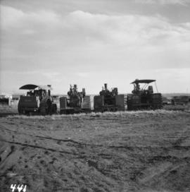
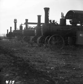
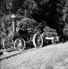
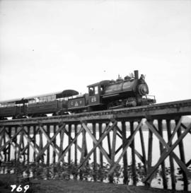
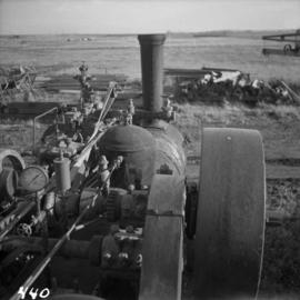
Photograph depicts a traction engine built by Sawyer Massey in Hamilton, Ontario. It has a single cylinder and large fire box for burning wood or straw. The engine is located in Nanton, Alberta.
Photograph depicts a rear view of 4 of the 6 traction engines in Nanton, Alberta. The left engine was built by Reeves and Co. in Columbus, Indiana, U.S. Its identification is #4438, it has 2 cylinder simple, and a roof. The next engine was built by Waterloo Mfg. Co. Ltd. in Waterloo, Ontario and has a single cylinder. The third engine was built by Sawyer Massey. The engine on the right side is a Gaar Scott, built in 1913, and has 25 horsepower on the drawbar and 75 horsepower on the belt.
Photograph depicts traction engines owned by Jack Burrows in Nanton, Alberta. There are six in this photo, all of which appear could be steamed, another two in derelict condition, and one in the village in working order. Running from front to rear in the photo: 1) Reeves with roof, U.S. 2) Waterloo, Ontario, Canada 3) Massey, Canada 4) Gaar Scott with roof, U.S. 5) Massey, Hamilton, Canada 6) Gaar Scott, U.S.
Photograph depicts a tractor owned by G. Wellburn at the Duncan Forest Museum.
Photograph depicts a train at the Cowichan Valley Forest Museum on Vancouver Island.
Photograph depicts a train at the Great Northern Railway Station in Vancouver, B.C.
Photograph depicts a train car backing up on the west side of the C.N. station in Hope. It is part of the West Coast Railway Association trip on August 8, 1964.
Photograph depicts two (out of three) cares lettered Morrissey, Fernie and Michel Railway, from whence they came in 1964. The worked on the Coal Creek line to Fernie until about 1959. They are on display at Heritage Park in Calgary.
Photograph depicts a train near Moyie on the CPR line. The end of the train was drawn by head end locomotive #6047. The train was westbound to Nelson, located at about mile 13 on the Nelson Subdivision, which starts at Cranbrook.
Photograph depicts the rear end of the first train of the 1994 season for the Rocky Mountaineer Rail Tours at the CN Downtown Depot in Kamloops.
Photograph depicts the junction station of the Esquimalt and Nanaimo Railway at Parksville on Vancouver Island. The view is looking south.
Photograph depicts trains switching at Osoyoos, BC.
Photograph depicts the Transformer Sub-Station of West Kootenay Power and Light Company, which is the only private power distribution company left in B.C. at the time. In was built in 1905 and was in operation by 1906. There were identical buildings made in Grand Forks and Phoenix, but they were demolished at the latter place.
Photograph depicts a trappeers cabin on the northend of Trout Lake and Trout Lake City. It was maintained in good condition by present owners who valued its age.
Photograph depicts a trestle bridge for road traffic leading to the Second Narrows Bridge in Vancouver, BCThe shot is taken from the south bank.
Photograph depicts the CPR Kettle Valley Railway in Myra Canyon. This is one of the nine wooden trestles between mile 85 and mile 86.4
Photograph depicts the CPR Kettle Valley Railway in Myra Canyon. It shows the a wooden trestle fitted with a sidewalk, which at 434 ft. long is the longest one in the canyon. It is located at mile 85.9. The view is looking south.
Photograph depicts the CPR Kettle Valley Railway in Myra Canyon. The view is looking north at the trestle located at mile 85.4
Photograph depicts the CPR Kettle Valley Railway in Myra Canyon. It shows the a wooden trestle fitted with a sidewalk, which at 434 ft. long is the longest one in the canyon. It is located at mile 85.9. The view is looking south.
Photograph depicts the CPR Kettle Valley Railway in Myra Canyon. It shows the a wooden trestle fitted with a sidewalk, which at 434 ft. long is the longest one in the canyon. It is located at mile 85.9. The view is looking north.
Photograph depicts a trestle bridge on the old CPR Kettle Valley Railway. It is about 5 miles southeast of Brookmere, between Thalia and Spearing on the Princeton Subdivision.
Photograph depicts a trestle on the south bank of the north arm of the Fraser River leading from the C.N.R. swing bridge, approximately 5 miles southeast of New Westminster, looking south.
Photograph depicts the trestle leading to the Canadian National Railway (CN) swing bridge across the north arm of the Fraser River. The view was taken on Lulu Island, looking northeast. The ground on each side of the trestle is peaty and springy when walked on.
Photograph depicts a trestle of the Great Northern Railway, main line to Blaine, curving towards the southwest from the south end of the New Westminster rail bridge.
Photograph depicts a trestle on the ex CPR Coquihalla line of the Kettle Valley Railway. It is a famous view spot because the trestle has a waterfall behind it. It is now the only intact trestle on the line because even the very small ones were demolished after the line closed on 23 November 1959. It is located about mile 21.7 from Brookmere. The grade here is about 1 in 53.
Photograph depicts Trout Creek Bridge of the KVR.
Photograph depicts the Trout Creek CPR bridge near Summerland, about 9 miles north of Penticton. It is about 620 ft. long and the creek is 240 ft. below it. It was part of the Kettle Valley Railway.
Photograph depicts the Trout Creek CPR bridge near Summerland, about 9 miles north of Penticton. It is about 620 ft. long and the creek is 240 ft. below it. It was first crossed by the Chief Engineer's train on October 25, 1913. The view is looking south east.
Photograph depicts the one and only service station that was in Trout Lake City. It had manual pumps as there was no distributed electricity in the village.
Photograph depicts a truck at the Teepoortens Truck and Equipment Rentals Ltd., located at 950 West 6th Ave. in Vancouver, BC
Photograph depicts an old truck that was found besides a logging yard and CNR trackage.
Photograph depicts truss bridge over Lois River looking north. Bridge is about 2-4 miles north of Saltery Bay, leading to Powell River.
Photograph depicts a truss bridge over the Salmon River near Kelsey Bay, North Vancouver Island.
Photograph depicts a tug at Kingcome Navigation Dock in Vancouver Harbour.
Photograph depicts a small tug being completely renovated on a floating scow.
Photograph depicts a tug towing gravel scow that was used to make concrete. Photograph taken at a BCER swing bridge.
Photograph depicts a small tugboat rescuing a motor cruiser that had been swept downstream in the Annacis Channel against a bridge, about 1.5 miles southwest of the Patullo Bridge, New Westminster.
Photograph depicts the tugboat "Brunette" at Westview Harbour, Powell River. It is registered in Vancouver.
Photograph depicts a tugboat named "Gillking" docked at an unknown location.
Photograph depicts the tugboat "Gulf Margaret" with a Straits scow leaving the north arm of the Fraser River and entering the main river at New Westminster, travelling upstream. The tug belongs to the Gulf of Georgia Towing Company.
Photograph depicts the tugboat "Island Sovereign" going to turn starboard after backing out from the dock. The view is looking southeast.
Photograph depicts the tugboat "Island Sovereign" moored at a dock in North Vancouver, 200 yards west of the Burrard Dry Dock, 2 days in service after refit.
Photograph depicts the tugboat "Island Sovereign" backing out at North Vancouver.
Photograph depicts the tugboat "Island Sovereign" with Burrard floating dock in the background.
Photograph depicts a steam tugboat named "Master" owned by the World Ship Society (Vancouver Chapter). Photograph taken during Carnival and Regatta week in Vancouver.
Photograph depicts a shed in Tulameen.
Photograph depicts the CPR Kettle Valley Railway in Myra Canyon. This is the southern portal of a 375 ft. long tunnel at about mile 85.7. Part of the bore is supported by timbers.
Photograph depicts the CPR Kettle Valley Railway in Myra Canyon. It shows the northern portal of a 277 ft. tunnel, located at mile 86.3.