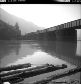
Postcard depicts Stoney Creek Bridge.
Postcard depicts Stoney Creek Bridge in the Canadian Rockies.
Postcard depicts Stoney Creek Bridge in the Selkirk Mountains of B.C.
Photograph taken at the CN Kamloops Junction on a storage line.
Photograph depicts the only store in the small, derelict village of about 12-15 houses of which only one is occupied.
Photograph depicts a store 50 yards south of the B.C. Electric Railway on the west side of the Vedder crossing road in Sardis, Chilliwack, B.C.
Photograph depicts machinery stored in Summerland beside KVR track. Property of the KVR Historical Society.
Photograph depicts stores in Kaslo on Kootenay Lake, 40 miles northeast of Nelson. This town still has 15 miles of dirt road leading to it.
Photograph depicts stoves taken from railway equipment at the C.N. Port Mann repair shops. Left and middle stove are of the same design.
Photograph depicts a street car body that formerly belonged to Vancouver, but was found by Davies in Penticton.
Photograph depicts former street car tracks in New Westminster.
Photograph depicts the Sumas depot of the Northern Pacific Railway in the U.S. The Canadian border is at the grade crossing in the middle distance.
Photograph depicts what is believed to be the only remaining "summer cottage" on Beach Ave. in English Bay.
Photograph depicts a train spotted at the Summerland depot.
Map depicts the cities of Summerland, Penticton, and Naramata. Annotated by Davies to emphasize the rail lines in the area.
Postcard depicts "Summit City" in Rogers Pass, built in 1886 and existed only for the consctruction of the CPR.
Photograph depicts the Sun Building at the intersection of Beatty and West Pender St. in Vancouver, B.C. The photo was taken after the Pacific Press Ltd. Vacated the building on December 26, 1965, and the "Sun" neon sign on the tower was removed. The view is looking west from West Pender St.
Photograph depicts block ships sunk to protect booming grounds at Powell River. The ships were former wartime naval vessels.
Photograph depicts a sunken whaler with a harpoon gun. A destroyer or, possibly, a corvette was being broken up in the middle background.
Photograph depicts the close up of harpoon guns of a sunken whaler in the Upper Harbour of Victoria.
Photograph depicts the Superior Propane Ltd. tank yard behind Wilkinson Steel Ltd.
Photograph depicts one of the surviving houses on Beach Ave, Vancouver, between Gilford and Chilco.
Photograph depicts the only surviving building in the ghost town of Gerard. Its survival was due to the ownership and periodic use of the B.C. Government Fisheries Department.
Photograph depicts a swimming pool at Second Beach in Stanley Park, Vancouver, B.C. The snow in the foreground is 16 inches deep and there is a gathering snowstorm in the background coming in from the west.
Photograph depicts the CPR swing bridge crossing the Harrison River at Harrison Mills. It is a plate girder bridge carrying a double track. The bridge tender occupied a shanty at the east end of the bridge at mile 68.3 from North Bend. The timetable states that trains may proceed at restricted speed after stopping, if the tender fails to appear after 4 whistle signals and the hone signals show stop.
Photograph depicts the swing span of the road and rail bridge at Mission City, looking upstream from the south bank.
Photograph depicts switcher #8106 that served the 3 mile branch to a pulp mill. The switcher pulled with heavy string of loaded cars from the mill. The trip was a caboose run. Locomotive built in 1958 as part of a batch of 31. 17 of them remained in 1997.
Photograph depicts switcher #8106 and caboose #434612 that just arrived with a loaded train from a pulp mill. To the left lay the main track to Nelson.
Photograph depicts a switching locomotive and stand-in locomotive.
Photograph depicts an old tank car owned by a logging railway on Vancouver Island, parked at the end of a spur behind a locomotive shed of the Alberni Pacific Railway.
Photograph depicts a new tank car for sodium chlorate CN/CP interchange.
Photograph depicts a tank that was found outside of the headquarters of the British Columbia Armoured Regiment in Vancouver.
Photograph depicts a tank 'Scale Test Car' at the Kamloops CPR yard.
Photograph depicts an old tannery that appeared to be being slowly renovated after years of disuse.
Photograph depicts a telegraph line on the Williams Lake to Bella Coola road.
Photograph depicts telephone fittings on Vancouver Island.
Photograph depicts a telephone pole near Reiswig, on the main road between Vernon and Arrow Lakes.
Photograph depicts ten ballast cars of the B.C. Electric Railway on newly laid industrial spur on the northeast side of the Langley depot.
Photograph depicts the Pacific Terminus of the Trans Canada Highway in Tofino, B.C. on Vancouver Island.
Map depicts location of treasure hidden between Clearwater and Clemina, BC.
Postcard depicts "Canadian Pacific's all Stainless Stel Scenic Dome Streamliner-"The Canadian"-in the Canadian Rockies."
Postcard depicts "VIA Rail Canada Nos. 6456 and 6454 hauling Train No. 1, "The Canadian" between Spences Bridge and Drynoch, British Columbia, on Canadian Pacific's Thompson Subdivision, having been delayed by the need to detour, from its usual route, on Canadian National's Ashcroft Subdivision, seen here across the Thompson River. May 14, 1993."
Photograph depicts the Canadian Bank of Commerce in Ladysmith, B.C. on Vancouver Island. Building is estimated to be built between 1901-1905.
Postcard depicts "Canadian Pacific's eastbound, "The Canadian," crosing the Kicking Horse River between Golden and Field B.C. in October 1976. Some of the... trains power through some of North America's most spectacular scenery. The morning has brought the season's first snowfall."
Tourist map of Prince George depicts city area, including railway trackage.
Postcard depicts "The Four Tracks."
Postcard depicts the Four Tunnels on the CPR line through the Rocky Mountains.