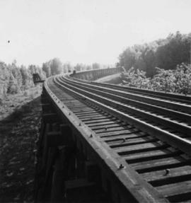
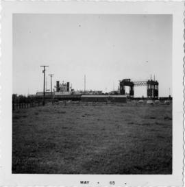
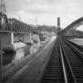
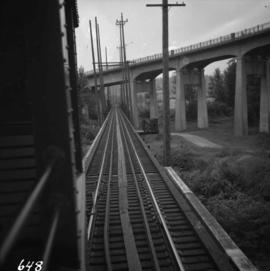
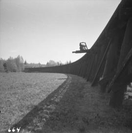
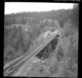
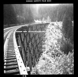
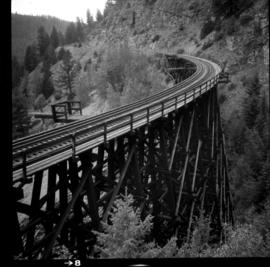
Photograph depicts the trestle leading to the Canadian National Railway (CN) swing bridge across the north arm of the Fraser River. The view was taken on Lulu Island, looking northeast. The ground on each side of the trestle is peaty and springy when walked on.
Photograph depicts a trestle on the south bank of the north arm of the Fraser River leading from the C.N.R. swing bridge, approximately 5 miles southeast of New Westminster, looking south.
Photograph depicts a trestle bridge on the old CPR Kettle Valley Railway. It is about 5 miles southeast of Brookmere, between Thalia and Spearing on the Princeton Subdivision.
Photograph depicts the CPR Kettle Valley Railway in Myra Canyon. This is one of the nine wooden trestles between mile 85 and mile 86.4
Photograph depicts the CPR Kettle Valley Railway in Myra Canyon. It shows the a wooden trestle fitted with a sidewalk, which at 434 ft. long is the longest one in the canyon. It is located at mile 85.9. The view is looking south.
Photograph depicts the CPR Kettle Valley Railway in Myra Canyon. The view is looking north at the trestle located at mile 85.4
Photograph depicts the CPR Kettle Valley Railway in Myra Canyon. It shows the a wooden trestle fitted with a sidewalk, which at 434 ft. long is the longest one in the canyon. It is located at mile 85.9. The view is looking south.
Photograph depicts the CPR Kettle Valley Railway in Myra Canyon. It shows the a wooden trestle fitted with a sidewalk, which at 434 ft. long is the longest one in the canyon. It is located at mile 85.9. The view is looking north.
Photograph depicts a trestle bridge for road traffic leading to the Second Narrows Bridge in Vancouver, BCThe shot is taken from the south bank.
Photograph depicts trains switching at Osoyoos, BC.
Photograph depicts the junction station of the Esquimalt and Nanaimo Railway at Parksville on Vancouver Island. The view is looking south.
Photograph depicts the rear end of the first train of the 1994 season for the Rocky Mountaineer Rail Tours at the CN Downtown Depot in Kamloops.
Photograph depicts a train near Moyie on the CPR line. The end of the train was drawn by head end locomotive #6047. The train was westbound to Nelson, located at about mile 13 on the Nelson Subdivision, which starts at Cranbrook.
Photograph depicts two (out of three) cares lettered Morrissey, Fernie and Michel Railway, from whence they came in 1964. The worked on the Coal Creek line to Fernie until about 1959. They are on display at Heritage Park in Calgary.
Photograph depicts a train car backing up on the west side of the C.N. station in Hope. It is part of the West Coast Railway Association trip on August 8, 1964.
Photograph depicts a train at the Great Northern Railway Station in Vancouver, B.C.
Photograph depicts a train at the Cowichan Valley Forest Museum on Vancouver Island.
Photograph depicts a tractor owned by G. Wellburn at the Duncan Forest Museum.
Photograph depicts a rear view of 4 of the 6 traction engines in Nanton, Alberta. The left engine was built by Reeves and Co. in Columbus, Indiana, U.S. Its identification is #4438, it has 2 cylinder simple, and a roof. The next engine was built by Waterloo Mfg. Co. Ltd. in Waterloo, Ontario and has a single cylinder. The third engine was built by Sawyer Massey. The engine on the right side is a Gaar Scott, built in 1913, and has 25 horsepower on the drawbar and 75 horsepower on the belt.
Photograph depicts traction engines owned by Jack Burrows in Nanton, Alberta. There are six in this photo, all of which appear could be steamed, another two in derelict condition, and one in the village in working order. Running from front to rear in the photo: 1) Reeves with roof, U.S. 2) Waterloo, Ontario, Canada 3) Massey, Canada 4) Gaar Scott with roof, U.S. 5) Massey, Hamilton, Canada 6) Gaar Scott, U.S.
Photograph depicts a traction engine built by Sawyer Massey in Hamilton, Ontario. It has a single cylinder and large fire box for burning wood or straw. The engine is located in Nanton, Alberta.
Photograph depicts lettering on several ballast cars which were headed by a tracktor and tailed by a caboose.
Photograph depicts a "trackmobile" in the CNR Boston Bar yard. Work on replacing ties was being carried out 5-10 miles to north.
Photograph depicts the trackage in the mid section of the McCulloch depot area. The left line is a passing track, the mid line is the mainline, and the right track is for storage. The depot is located at mile 76.6, on the Carmi Subdivision. The view is looking north.
Photograph depicts trackage near the CPR depot in Salmon Arm.
Photograph depicts the track transfer transporter at the Canadian National Railway (CN) repair shops at Port Mann, showing the east face of the main building.
Photograph depicts a track shed about 1 mile south of Beaverdell or at about mile 43.25 on the CPR line in the Carmi Subdivision. Despite the open doors and ease of access, it was the only hut on the line found to contain track materials and correspondence. It retained 50 memos addressed to the Section Foreman [at Beaverdell?].
Photograph depicts a CN Track Geometry 'Test" car for Western Canada. Built in 1954 as "Cape Race." In 1983 it was a VIA sleeper/buffet/lounge.
Photograph depicts a track car model (in fact, the base to the lamp shade).
Photograph depicts a tower controlling the C.P.R. grade crossing at Alexander St. in Vancouver, B.C.
Photograph depicts the view of the Tilbury rail terminal on the south bank of the south arm of the Fraser River, 1 1/2 miles east of Deer Island Tunnel. S.S. Canora is also in the picture.
Photograph depicts Tilbury dock on the Delta shore of the Fraser River. The stern of the Canadian National Railway (CN) onboard railcar carrier SS "Canora" is about 10ft away, and showing tidal and moving a piece of dock leading to shore.
Photograph depicts three crossing at Second Narrows in Vancouver Harbour. On the left was a new CNR bridge being built. In the middle was exsiting CN track. To the right a high level road bridge is visible.
Photograph depicts three B.C. Electric Railway locomotives on running line to the west of car barn at New Westminster.
Photograph depicts CN track 1 mile east of Walhachin. Looking east. Thompson River running downstream, towards the camera. CPR also goes through Walhachin.
Photograph depicts CN track 1 mile east of Walhachin. Looking east. Thompson River running downstream, towards the camera.
Photograph depicts the split of the Great Northern Railway (GNR) (shown) and the Canadian National Railway (CN) tracks, immediately south of the Fraser crossing at New Westminster.
Map depicts the route of BC Rail and its connecting rail lines.
Photograph depicts the "Princess of Vancouver" loading at 7 p.m. in Vancouver.
Postcard depicts the Canadian Pacific Railway line where the Great Divide between BC and Alberta.
Map depicts location of treasure hidden between Clearwater and Clemina, BC.
Photograph depicts ten ballast cars of the B.C. Electric Railway on newly laid industrial spur on the northeast side of the Langley depot.
Photograph depicts telephone fittings on Vancouver Island.
Photograph depicts a tank 'Scale Test Car' at the Kamloops CPR yard.
Photograph depicts a tank that was found outside of the headquarters of the British Columbia Armoured Regiment in Vancouver.
Photograph depicts a new tank car for sodium chlorate CN/CP interchange.