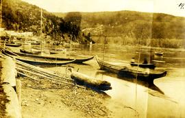
Photograph depicts two unidentified individuals in canoe on Boya Lake, B.C. (formerly known as Chain Lakes). Foliage silhouetted in foreground; forest and hills on opposite shore in background.
Photograph depicts trees and pickup trucks in front of long building speculated to be an apartment residence.
Photograph depicts the Cominco Ltd. In Kimberley, near Cranbrook. There is a 3' gauge overhead electric railway serving the underground workings of Sullivan mine. The view shows the C.P.R. access in the valley and the old mine portal, still used for in-going materials and supplies, at the right center of the photo.
Photograph depicts the "Comanchero II" boat in the Prince Rupert Marina. Another building and boat are visible in the background.
Water level photograph of several small vessels gathered around a large cold storage building. Printed annotation on recto reads: "Cold Storage, Prince Rupert B.C. 66."
Photograph depicts the coking ovens at Union Bay on Vancouver Island. They belong to the Canadian Collieries Ltd. and the date last used is unknown.
Photograph depicts the coaling wharf at Union Bay on Vancouver Island. It is the property of the Canadian Colliery Resources Ltd. It was last used on August 15, 1960. Thereafter, all equipment and railways were dismantled but the water tank is still standing.
Photograph depicts coal miners near Buckley Bay. The afternoon shift (3 p.m.) is going down the Tsable drift mine, which is the only working coal pit on Vancouver Island in 1964 and has a total of 70 employees. It is run by the Comox Colliery Co. and has a daily production of 200-300 tons.
Photograph depicts the Tsable coal pit on Vancouver Island as the first coal of the afternoon shift being hauled up.
Photograph depicts exposed asbestos fibre in talus.
Close view of dock full of rows of nets and a few workers. Rows of bunkhouses on shore in background. Handwritten annotation in pencil on recto reads: “Port Essington B. C.”
Image depicts a highway, and a section of mountain in the background which is bare due to clear-cut logging. It is possibly somewhere near Prince George, B.C.
Image depicts a logging area, and a section of mountain in the background which is bare due to clear-cut logging. The slide is also labelled "logging show." It is possibly somewhere near Prince George, B.C.
Photograph depicts three men with fishing gear. Trees and mountains in background. Left to right: Plato Malezemoff (holding fish), Jack Christian, Tam Zimmermann.
Photograph depicts three men fishing from shore. Water and trees in background. Left to right: Jack Christian, Plato Malezemoff, Tam Zimmermann.
Item is a photograph of a CP Rail chip car being dumped. The development of the interior chip pulp industry necessitated new designs for chip rail cars and their dumping facilities.
Image depicts a view of a saw mill in Chetwynd, B.C.
Photograph of a Canadian Grain elevator next to the railway in Prince Rupert, BC. Printed annotation on recto reads: "C.G. Elevator. Prince Rupert."
Item is a photograph of a ribbon cutting ceremony.
Photograph depicts large Caterpillar engine on flatbed. Road in foreground, trees in background. Accompanying note reads: "MTCE 4-01 (b) Cat 3612 Engine".
Photograph depicts large Caterpillar engine in large shop with sheeted walls and brick floor. Accompanying note reads: "MTCE 4-01 (b) Cat 3612 Engine".
Photograph depicts large Caterpillar engine against painted brick wall in building with brick floor. Miscellaneous equipment in background. Accompanying note reads: "MTCE 4-01 (b) Cat 3612 Engine".
Photograph depicts the Cassiar townsite behind shadow in foreground. Plantsite can be seen including the mill, dry rock storage building, tailings pile, and many other buildings. Mountains in background. Handwritten annotation on recto: "<- 13 1/2" ->". (This photograph was made into a promotional poster.)
This file contains images of a land dispute around Cassiar. The photographs depict a cabin on a lot, a destroyed cabin, and outhouses. The accompanied documents in the original file refer to the subjects of "Claims, Leases, and Land lots," and it is implied that there were issues of squatters, illegal occupation, and mineral claims.
Image depicts the Carter Industrial Area in Prince George, B.C.
Buildings visible on shore in distance.
Handwritten annotation on verso reads: "Amidst drift ice on Fishing Bay Nass River. Insert at Page 38. Indian Fishing Encampment".
Photograph depicts a cannery on pilings over the water with other cannery buildings in the background.
Photograph depicts a line of cannery fishing boats being towed across the water with the base of a mountain in the background.
Photograph depicts a distance perspective of several cannery buildings with a body of water in the foreground and a mountain range in the background.
Photograph depicts a building under construction with wood planks on the dock in the foreground and a forested area in the background.
Photograph depicts cannery buildings on wooden pilings with a body of water in the foreground and a forested area in the background.
Photograph depicts cannery buildings on pilings with a body of water in the foreground and tree covered mountains in the background.
Photograph depicts cannery buildings on pilings with a body of water in the foreground and a deforested area behind the shoreline.
Image depicts the BC Packers Ltd. cannery in Prince Rupert, B.C.
Image depicts numerous piles of wood planks at the Canadian National Railway Yards in Prince George, B.C. The cutbanks are seen in the background.
Photograph of a factory on the shoreline amidst a forested area. The factory is emitting steam or smoke and has a white exterior. Annotation on recto reads "Canadian Fish & Cold Storage Co. Prince Rupert BC."
Photograph depicts five long buildings in forest clearing, lining left of a road down the center of the image. Wood piles are stacked against buildings. Men can be seen in distance near a white tent.
Photograph depicts a numerous variety of buildings in snowy clearing of forest. A car is parked in foreground on road leading into the camp. Handwritten caption beside this photo reads: "Sumit Lake Camp". It is speculated that this may be the Campbell Construction Co. road camp.
Photograph depicts the camp at Summit Lake, B.C., a numerous variety of buildings in snowy clearing of forest. A car is parked in foreground on road leading into the camp. It is speculated that this may be the Campbell Construction Co. road camp.
Photograph depicts the boom, stick, and bucket of a "Northwest" cable shovel loading a dump truck in excavation area, snow and forest in background.
Overview of Giscome, BC showing built and natural landscape.
Handwritten annotation in pencil on verso: "Bunkhouse & Dining Room / Giscome BC".
Image depicts the entrance to a mine with an unknown individual present. It is possibly the entrance to the closed Britannia Mine in the Howe Sound Region.
Image depicts a number of old buildings, possibly located at the closed Britannia Mine.
Image depicts a piece of industrial machinery, possibly located at the closed Britannia Mine. Two unknown individuals are also present in the image.
Image depicts a conveyor belt, possibly located inside one of the old buildings at what is possibly the closed Britannia Mine.
Image depicts the inside of a mine with an unknown individual present. It is possibly the inside of the closed Britannia Mine.
Image depicts the Bridge River No. 1 hydroelectric station on the shore of Seton Lake (rear side of powerhouse).
Image depicts the old sales office of Bralorne Pioneer Mines Ltd. which is now the Bralorne Pioneer Museum.