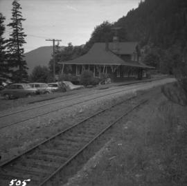
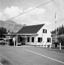
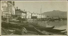
Photograph depicts Businesses in downtown in the North Thompson region, including a business called 'Something old & Something new'.
Photograph depicts Businesses in downtown in the North Thompson region, including a sign reading "Welcome to historic George Street" and a business called "Lizard River".
Photograph depicts Businesses in downtown in the North Thompson region, including a sign reading "Welcome to historic George Street" and Levi's jeans store.
Photograph depicts "Butterchurch" that was built in 1870 under the direction of Father Rondeault of the Oblate Order for missionary work among the Comiakan Natives, a tribe of about 100. It was abandoned by about 1880 because of its location. It was recently restored as a historical shrine.
Image depicts a cabin at an unknown location.
Image depicts a cabin somewhere in Mud River, B.C.
Image depicts a cabin at an uncertain location.
Image depicts a cabin somewhere in Mud River, B.C.
Photograph depicts a log cabin with sod roof in forest clearing. Handwritten annotation on recto of photograph: "Sayer Creek."
Photograph depicts a cabin near Williams Lake. Its interior contained two old treadle sewing machines and a chesterfield. Davies had the impression it had not been inhabited for at least a decade.
Photograph depicts Cadero St. in the west end of Vancouver, looking north from Barclay St. intersection in the 800 block.
The item is a photograph depicting the Caine building in Prince George.
Buildings visible on hillside in background, pier in foreground. Photo believed to have been taken at Port Simpson, B.C.
File contains slides depicting places in California, USA.
Photograph depicts the Cameron Lake station on the Alberni branch of the Esquimalt and Nanaimo Railway on Vancouver Island. It is no longer used but has been converted to a lodge. The view is looking west.
The item is a photograph depicting the Cameron Street bridge. The photograph is a reproduction of a photograph taken between 1917 and 1932. The picture depicts an ice jam with snow and ice along the Nechako River reaching the height of the base of the bridge. Annotations on the reverse of the photograph state, "Exp. Pl = 1922 p 986.9.9 Exp Pl = 16 Dec 1917 p 982 " 38.3 P 982.30.68 old bridge - can't be 1932."
The item is a photograph depicting the Cameron Street bridge. The photograph is a reproduction of a photograph taken between 1916 to 1931. The picture depicts the completed wooden Cameron Street bridge over the Nechako River. Annotations on the reverse side of the photograph state, "1st bridge between 1916 - 1934 983.7.13." Attached yellow sticky note states, "Note pilings in swing span. Ted Williams says the span was replaced with extension in 1922. So this photo is post - 1922."
The item is a photograph depicting the Cameron Street bridge plaque. The short write up details the construction and significance of the bridge. Annotations on reverse side of the photograph state, "169 words."
The item is a photograph slide reproduction depicting the Cameron Street bridge in Prince George. The river is flooded with and ice jam reaching the height of the bottom of the bridge. Annotation on the slide states, "Cameron bridge 1916-1931."
File consists of notes, clippings, and reproductions relating to the Cameron Street Bridge in Prince George. Includes: "Oral History Consent Form" document signed by Kent Sedgwick and researcher Angela Quibell (8 Aug. 2007); "What Price Heritage? The Case of the Cameron Street Bridge in Prince George, British Columbia" typed document by Angela Quibell (2007); "Interview with Kent Sedgwick" typed transcript of an oral interview with Kent Sedgwick and Angela Quibell (8 Aug. 2007); and "Nechako Crossing" typed document by Kent Sedgwick (Nov. 2005). Also includes photographs depicting the Nechako bridge model (2008), the plaque describing the history of the 3rd Cameron Street Bridge built in 2009, and the 1st Cameron Street Bridge built in 1916 (photographic reproduction ca. 2008).
Image depicts an unknown individual eating in a camp somewhere in South Tweedsmuir Provincial Park.
Photograph depicts a numerous variety of buildings in snowy clearing of forest. A car is parked in foreground on road leading into the camp. Handwritten caption beside this photo reads: "Sumit Lake Camp". It is speculated that this may be the Campbell Construction Co. road camp.
Photograph depicts the camp at Summit Lake, B.C., a numerous variety of buildings in snowy clearing of forest. A car is parked in foreground on road leading into the camp. It is speculated that this may be the Campbell Construction Co. road camp.
Street view photograph of a commercial section in downtown Prince George with several "Campbell's" delivery carts parked along the road. Visible establishments include "Campbell's All Cash Store" and "Club Cafe." Handwritten annotation in blue ballpoint pen on recto reads: "Howdy from Prince George! Going easy with all these kids- good to see Kathee. Snow here. Have fun at the sports show & don't over do it. Thinking of you guys, love Judy and Vic. P.S. Can't wait to go home to somewhere peaceful and quiet. 2-27-83." Postcard is addressed to: "Mr. & Mrs. Hauffer 8429-221 PL. Sn. Edmonds, WA. U.S. 98020." Verso is affixed with four Canadian 8-cent stamps.
Image depicts numerous campers and other vehicles in Tumbler Ridge, B.C.
Photograph depicts five long buildings in forest clearing, lining left of a road down the center of the image. Wood piles are stacked against buildings. Men can be seen in distance near a white tent.
The item is a photograph depicting the exterior view of the front of The Health and Welfare Canada Medical Services building at 1294 3rd Avenue, Prince George. There is a grey and red Ford pickup truck parked in front of the building. Part of Household Finance HFC at 1272 3rd Avenue can be seen. Photograph originally taken between 1978 and 1979.
The item is a photograph depicting the exterior view of the front of The Health and Welfare Canada Medical Services building at 1294 3rd Avenue, Prince George. There is a grey and red Ford pickup truck parked in front of the building. Photograph originally taken between 1978 and 1979.
The item is a photograph depicting the exterior view of the front of The Health and Welfare Canada Medical Services building at 1294 3rd Avenue, Prince George. Savers Optical can be seen in the background. Photograph originally taken between 1978 and 1979.
Photograph depicts Canada Trust/ Realtor at 1633 4th Avenue.
Photograph depicts a Canadian Customs House. The border crossing was only open between 8:00 a.m. and 5:00 p.m. daily.
Photograph of a factory on the shoreline amidst a forested area. The factory is emitting steam or smoke and has a white exterior. Annotation on recto reads "Canadian Fish & Cold Storage Co. Prince Rupert BC."
Image depicts the Canadian National Railway Yards in Prince George, B.C.
Image depicts the BC Packers Ltd. cannery in Prince Rupert, B.C.
Photograph depicts a building under construction with wood planks on the dock in the foreground and a forested area in the background.
Photograph depicts an empty canoe floating directly in front of small white tents on opposite shore. Forest trees in background.
Image depicts a church and several other buildings in Canoe Creek.
Image depicts a house located somewhere in or near Canoe Creek.
Image depicts a view of Canoe Creek.
View of Pier and cluster of houses with trees in the background. Water crosses midground, canoes on beach in foreground. Printed annotation on verso reads: “Port Simpson.", handwritten in pencil: “B.C. 1907”.
Canoes sit on shore in foreground beside village buildings. A dock is visible above water in background.
Handwritten annotation on verso reads: "Alert Bay Indian Ranch No. 14 Alert Bay. To be shown on page 69 or 70, re Alert Bay Mission."
Buildings visible on shore in distance.
Handwritten annotation on verso reads: "Amidst drift ice on Fishing Bay Nass River. Insert at Page 38. Indian Fishing Encampment".
Photograph depicts a monument and grave stone for Captain Frank Odin of the Steamboat Charlotte. Annotation on verso: "Capt. Odin Monument, Soda Creek cemetery, 2010".
Handwritten photo album caption below this photo reads: “Cpt. Read.” Photograph depicts the captain sitting in open doorway of Officers’ Quarters [see item 2006.20.12.15] at Fort St. John. Wood slat sidewalk in foreground.
Royal Canadian Air ForceHandwritten photo album caption below this photo reads: “The Next Morning.” Photograph depicts man believed to be Captain Read, arms linked with a second unidentified man in uniform. The two men are standing on wood slat sidewalk in front of building with many windows speculated to be barracks [see item 2006.20.12.16] at Fort St. John. This photograph was beside item 2006.20.12.19 which depicts unidentified man in this photo and a second man, ready to go out for the evening.
Royal Canadian Air ForceImage depicts the train station in Carcross, Y.T.
Photograph taken at terrace gardens, Government House in Victoria, B.C.
Image depicts a log house at an uncertain location; the slide is simply labelled "Cariboo."