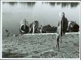
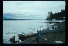
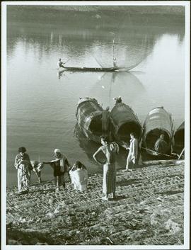
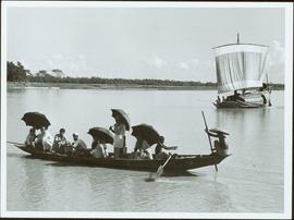
Item is a photograph of people in a boat on a river with another boat in the background.
Item is a photograph of people and boats on a river’s edge.
Item is a photograph of a forested area with man riding a elephant with two others nearby.
Item is a photograph of a house under construction. Unknown individual sits on ground in foreground.
Item is a photograph of a forested area.
Item is a photograph of a fishing boat with the net deployed with other boats and people on shore.
Item is a photograph of people fishing in a boat with nets.
Item is a photograph of the Chittagong Research Institute buildings.
Item is a photograph of a rural area taken from the air.
Item is a photograph of a river bend and the surrounding country taken from the air.
Handwritten annotation on verso reads: “Bald Eagle, Skidegate, 2007”.
Image depicts a back road at an uncertain location, possibly near Iron Road North, north of Woodpecker, B.C.
Image depicts a boat on Babine Lake, taken from Granisle, B.C.
Image depicts Babine Lake.
Photograph depicts a view from the shore of Babine Lake looking across the water to forest and snowy mountain peaks in the distance. [55th parallel]
Image depicts several unknown individuals on the shore of Babine Lake.
Image depicts two unknown individuals pulling a canoe through Babcock Lake's three mile creek.
Photograph depicts a group of men and dogs standing outdoors in the sunshine.
Slightly elevated view of the Prince Rupert Inn on Avenue A. Printed annotation on recto reads: "Avenue A Prince Rupert BC Allen Photo." Handwritten annotation on verso reads: "August 9 1908 Hopping[sic] this will find you all well with kind regards. [illegible]. C Mouat." Postcard is addressed to: "Miss Jemima Colvin Rosedale Farm Cowichan Station B.C." Verso affixed with a one cent Canadian stamp. Postmark on verso reads: "Prince Rupert BC Au 9 08."
Image depicts a glacier at an uncertain location; the slide is labelled "before."
Image depicts a glacier at an uncertain location; the slide is labelled "after two days," and shows how much it has melted.
Image depicts a glacier at an uncertain location; the slide labels it as "avalanche glac."
Image depicts a glacier on the side of a road at an uncertain location; the slide labels it as "avalanche glac."
Image depicts a glacier at an uncertain location; the slide labels it as "avalanche glac."
Item is an original 1983 map depicting Atnarko River in British Columbia, published by the Province of British Columbia Ministry of Environment.
Photograph depicts town site in foreground, lake and mountains in background. Handwritten annotation on recto of photograph: "Atlin: Atlin, Atlin Lk, & Atlin Mts. looking N.west from Glassey's (Govt. Agent) window."
Photograph depicts the Atlin townsite, forest in foreground, hills in background. Town stands on edge of lake located in left midground. Handwritten annotation on verso of photograph: "Atlin City B.C., Sept. 3rd 1899. Copyrighted by S.A. Smythe Atlin, B.C."
Image depicts a mountain somewhere along what is possibly the Atlin Road.
Image depicts what is possibly Atlin Road. Numerous mountains are visible in the distance.
Photograph of a vessel in a large body of water with several mountains visible in the background. Printed annotation on recto reads: "Atlin Mt., Atlin, B.C."
Image depicts a mountain, possibly Atlin Mountain.
Image depicts what is possibly Atlin Lake, with numerous mountains in the distance and Atlin Mountain visible on the right of the image.
Image depicts Atlin Lake as well as a small section of Atlin, B.C. The mountain is possibly Atlin Mountain.
Image depicts Atlin Lake.
Image depicts a boat named "the Tarahne," which is located in Atlin, B.C. Atlin Lake and Mountain are visible in the background.
Image depicts the post office in Atlin, B.C.
Image depicts an old boat on the shore of Atlin Lake.
Image depicts a building which once served as the residence for two nurses in Atlin, B.C. A sign in front of the house reads: "Grateful Atlinites built this house in 1902 for their first missionary nurses, Helen Bone and Elizabeth Mitchell, who came here in 1899 and lived in a crude shack while valiantly and humanely caring for sick and dying pioneers."
Image depicts numerous old buildings on a main street in Atlin, B.C.
Image depicts an old building undergoing a restoration process, possibly in Atlin, B.C.
Image depicts a back street in Atlin, B.C.
Image depicts a dock on the shore of Atlin Lake, as well as a building that may have once been a hospital. The slide is simply labelled "hospital."
Photograph of several log buildings and mining equipment in winter. Printer annotation on recto is mirrored and reads: "At The Red Cliff Red Cliff."
Photograph depicts rolling hills with dry vegetation and river in the background.
File contains slides depicting buildings and places in and around Ashcroft, Kamloops, and Hat Creek, B.C.
Image depicts Ash Street and Patricia Boulevard in Prince George, B.C.
File consists of the following articles and speeches written by Knox McCusker:
- "Reminiscences of Knox McCusker" (63 typewritten pages)
- "Back and Beyond the Peace" by K.McCusker (taken from the Toronto Star Weekly Saturday May 5, 1928) – retyped
- "The Alaska Highway" by Knox F. McCusker, D.L.S. (The Canadian Surveyor, July 1943)-photocopy
- Mr. McCusker's speech (5 pages)
- “Tropical Valleys of B.C.” (4 pages)
- "The president has called me an old old surveyor…" speech written by K. McCusker
- "In the early days of my career in the Surveying profession…" written by K. McCusker
File consists of the following items:
- "Mac" by D.L. Surveyor
- "Knox (Mac) McCusker: Dominion Land Surveyor" by E.L. Rutherford, V.C. Brink, R.S. Silver and M.Z. (Smokey) Neighbour
- Excerpts from Men and Meridians by Don W. Thomson
- Article re: Knox McCusker written on the occasion of his death (April 14, 1955)
- "McKusker (sic) to open up Blueberry Mountain Area" (Alaska Highway News, June 8, 1950)
- "McCusker was surveyor, big game guide….also rancher and trail blazer"
- "Knox Freeman McCusker" written on the occasion of his death (The Canadian Surveyor, July 1955)
- "Veteran Surveyor - Alaska Highway Stories"
- Memories of Knox McCusker by his oldest niece Betty (McCusker) Rutherford
- "Veteran Surveyor prefers horses for long bush treks" by Eric Young (Edmonton Journal)
- Eulogy for Knox McCusker read by Stanley D. Seif at Burch Presbyterian Church in Fort St. John, B.C.
- Eulogy for Gwendolyn Dorothy McCusker (July 1997)
- "Tropical Valley No Myth: amazing story of woman who lived there" by Thomas A. Wayling (Vancouver Sun)
- Photocopy of section of map: "Topographical sketch map showing route traversed by the Bedaux Sub-Arctic Expedition 1934 through the Rocky Mountains" (by Frank Swannell, March 27, 1935)
- Memories of Knox McCusker by Bill McCusker, his oldest nephew
- "There is always a reason; destiny made it a date. The corridor of the Alcan didn’t just happen" (Fort St. John publication)
- Article on Knox McCusker (ALS News, Winter 1983)