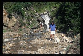
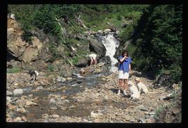
Image depicts two individuals and three dogs standing by a stream at an uncertain location, possibly somewhere in Bear Glacier Provincial Park. The woman in purple is possibly Sue Sedgwick.
Image depicts two individuals and two dogs standing by a stream at an uncertain location, possibly somewhere in Bear Glacier Provincial Park. The woman in purple is possibly Sue Sedgwick.
Image depicts two trucks on a road at an uncertain location.
Image depicts the hiking group packing their gear into two vans.
Image depicts a two-room schoolhouse in Penny, B.C.
Image depicts four individuals sitting on a log, possibly somewhere near the Hansard Bridge, B.C. The individuals are UNBC faculty members Gail Fondahl, Tracey Summerville, Greg Halseth and an unidentified individual. The slide is labelled: "Hansard Bridge UNBC." Map coordinates 54°04'37.7"N 121°50'39.9"W
Image depicts a house in Upper Fraser with the residential area in the background. Map coordinates 54°07'02.8"N 121°56'37.5"W
Image depicts a view of the Upper Fraser Canyon.
Image depicts a view of the upper Fraser Canyon.
Image depicts a view of the Upper Fraser Canyon.
Image depicts a view of the upper Fraser Canyon. The Fraser River is visible on the left side of the image.
Image depicts a view of the upper Fraser Canyon.
Image depicts the Upper Fraser Canyon.
Image depicts a view of the eastern part of the upper Fraser Canyon.
Image depicts the Fraser River passing through the upper Fraser Canyon.
Image depicts a view of the Upper Fraser Canyon. The Fraser River is visible.
Image depicts the Fraser River running through the Upper Fraser Canyon.
Image depicts a view of some of the scenery near the Upper Fraser Canyon.
Image depicts an unknown woman on a road in the upper Fraser Canyon.
Image depicts the Upper Fraser General Store in Upper Fraser, B.C. Two other signs indicate that it is also a post office and a place that offers propane refills. Map coordinates 54°07'10.8"N 121°56'51.7"W
Image depicts several houses, likely in Upper Fraser, B.C.
Image depicts entrance to mill yard for Upper Fraser mill in Upper Fraser, B.C. Map coordinates 54°07'10.8"N 121°56'51.7"W
Image depicts Upper Fraser mill yard with log deck and beehive burner in silhouette across railroad tracks. Located in Upper Fraser, B.C. Map coordinates 54°07'01.5"N 121°56'29.6"W
Image depicts numerous log decks at the Upper Fraser sawmill. Map coordinates 54°07'10.8"N 121°56'51.7"W
Image depicts the entrance to the Upper Fraser mill yard in Upper Fraser, B.C. Map coordinates 54°07'10.8"N 121°56'51.7"W
The item is a CD-R containing Kent Sedgewick's files regarding the Upper Fraser Valley history. Files include literature summaries, oral history transcripts and various other documents referring to the Upper Fraser Valley. Annotations on CD-R state, "Jun 7 '04 Kent - UF files to start."
Image depicts the Upper Fraser Road running through Upper Fraser, B.C. A beehive burner is seen in the background on the left and the mill office is seen on the right. Map coordinates 54°07'05.7"N 121°56'38.9"W
Image depicts several unidentified individuals walking along the snow-covered Upper Fraser Road with numerous buildings on either side. Map coordinates 54°07'05.7"N 121°56'38.9"W
Image depicts an individual standing next to what appears to be the base of a very large, uprooted tree, located somewhere in the coastal forest of Haida Gwaii, B.C.
File contains slides depicting places along Route 80 in the USA.
File contains slides depicting various places in the USA.
Image depicts a view of Valemount, with numerous mountains in the background.
Image depicts a view of a mountain range near Valemount, B.C. Valemount is barely visible among the trees on the right side of the image.
Image depicts a view of Valemount with numerous mountains in the background.
Image depicts a distant view of what appears to be a body of water, with numerous mountains in the background. The slide is labelled "Valemount reservoir."
Image depicts a view of a small valley in Mt. Robson Provincial Park.
Image depicts a river running through a valley-like area somewhere near Bralorne, B.C.
Image depicts a valley of fossil beds, possibly the Bulkley Valley.
Image depicts an example of varves, an annual layer of sediment or rock, with a pipe used for reference size. It is possibly located at the airport in Prince George, B.C.
Image depicts an example of varves, an annual layer of sediment or rock, possibly located at the airport in Prince George, B.C.
File contains slides depicting vegetation and a few maps.
Image depicts a view over a forested, mountainous area and a river somewhere in the area of Skagway, Alaska.
Image depicts a view over a forested, mountainous area and a river towards the vicinity of Skagway, Alaska.
Image depicts a view of the Millar Addition suburb from Connaught Hill in Prince George, B.C.