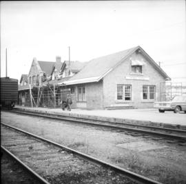
Street view photograph of a large brick with a vehicle parked in front. Printed annotation on recto reads: "C.N.R. Station Prince George, B.C."
Photograph depicts a bridge at the east end of the CNR yards in Prince George, crossing the Fraser River.
Photograph depicts the CNR depot in Prince George. To the right area of the photograph lay the downtown area of the city.
Photograph depicts the CNR depot. Considerable renovation work was taking place on both sides of the building and in the interior nearest to the camera.
Photograph depicts a rail bridge over the Fraser River. Canter levelled on both sides were vehicle roadways which ceased to be used in 1987 when a new road bridge was supposed to be completed. The right lane took cars into the city of Prince George.
Photograph taken somewhere between Endako and Prince George, Nechako Subdivision.
Photograph taken somewhere between Prince George and McBride.
Image depicts a number of trains in the CNR train yard taken from River Road in Prince George, B.C. Map coordinates 53°54'51.5"N 122°43'29.6"W
Photograph depicts a CN bridge crossing over the Fraser River. Built by Grand Trunk Pacific Railway in 1914.
Photograph depicts a CN bridge crossing over the Fraser River.
Photograph depicts a CN bridge crossing over the Fraser River. Built by Grand Trunk Pacific Railway in 1914.
Photograph depicts a CN bridge crossing over the Fraser River.
Photograph depicts a CN bridge crossing over the Fraser River. Details of the draw span captured.
Photograph depicts a CN bridge crossing over the Fraser River.
Photograph depicts a print taken fron a slide supplied by a professional photographer, Al Harvey. Captures a CN bridge crossing over the Fraser River.
Photograph depicts a CN bridge crossing over the Fraser River. It used to be a public roadway for eastbond traffic only.
Photograph depicts a CN bridge crossing over the Fraser River. Built by Grand Trunk Pacific Railway in 1914.
Photograph depicts a CN bridge crossing over the Fraser River.
Photograph depicts a CN bridge crossing over the Fraser River. Built by Grand Trunk Pacific Railway in 1914.
Photograph depicts a CN bridge crossing over the Fraser River.
Photograph depicts a CN bridge crossing over the Fraser River. Details of the draw span captured.
Photograph depicts a CN bridge crossing over the Fraser River. Built by Grand Trunk Pacific Railway in 1914.
Photograph depicts a CN bridge crossing over the Fraser River.
Photograph depicts a loaded coal train en rout to Prince Rupert travelling on a CN bridge that crossed over the Fraser River.
Photograph depicts a CN caboose. Possibly taken in Prince George.
Image depicts the CN Building in Prince George, B.C.
Stamped annotation on verso reads: "MAY 1994".
The Nechako Bridge is also known as the Cameron Street Bridge
Slide depicts a cleared area in a forest, likely at the Aleza Lake Experiment Station.
Image depicts a clearing at Island Cache.
Slide depicts a cleared area at the Aleza Lake Experiment Station with plant regeneration.
Image depicts a highway, and a section of mountain in the background which is bare due to clear-cut logging. It is possibly somewhere near Prince George, B.C.
Image depicts a logging area, and a section of mountain in the background which is bare due to clear-cut logging. The slide is also labelled "logging show." It is possibly somewhere near Prince George, B.C.
Image depicts the Prince George Civic Centre.
Item is Map 3 of a group of five maps relating to a City of Prince George Study of Construction Aggregates by the firm Willis, Cunliffe, Tair & Company Limited. Map 3 shows geology of the Prince George area and known sources of construction aggregates.
Item is Map 5 of a group of five maps relating to a City of Prince George Study of Construction Aggregates by the firm Willis, Cunliffe, Tair & Company Limited. Map 5 shows drill hole locations.
Item is Map 4 of a group of five maps relating to a City of Prince George Study of Construction Aggregates by the firm Willis, Cunliffe, Tair & Company Limited. Map 4 shows development areas, aggregate sources, and requirements for 1984 and 1994. As the map is undated, it is unclear whether the 1984 and 1994 dates are future estimates.
Item is Map 1 of a group of five maps relating to a City of Prince George Study of Construction Aggregates by the firm Willis, Cunliffe, Tair & Company Limited. Map 1 shows development areas and population for 1984 and 1994. As the map is undated, it is unclear whether the 1984 and 1994 dates are future estimates.
Item is Map 2 of a group of five maps relating to a City of Prince George Study of Construction Aggregates by the firm Willis, Cunliffe, Tair & Company Limited. Map 2 shows development areas and aggregate requirements for 1984 and 1994. As the map is undated, it is unclear whether the 1984 and 1994 dates are future estimates.