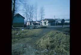
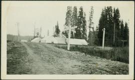
Image depicts mobile homes for sale on Cowart Road looking northeast with Simon Fraser Bridge in background. Map coordinates 53°52'39.3"N 122°46'13.1"W
Image depicts a trailer park by either the Fraser or Nechako River in Prince George, B.C.
Image depicts trailer homes in Prince George, B.C.
Photograph taken from the intersection of 3rd Avenue and an unidentified street. Visible businesses include "Ben Baird The Smart Shop" and "C.N.R. Cafe." Printed annotation on recto reads: "3rd Ave. PR. George, B.C."
Image depicts 3rd Ave in Prince George, B.C. Map coordinates 53°55'01.9"N 122°44'48.7"W
Street level photo of Third Avenue in Prince George. Visible businesses include "Cut Rate Grocery" and "C.N.R. Cafe." Printed annotation on recto reads: "3rd Ave. Prince George."
Back, left to right: Ellen (nee Taylor) and husband Percy Garland, Joan Graves (daughter of Lucy Taylor), Dick Baxter (son of Violet), Violet (nee Taylor) Baxter. Front, left to right: [unknown], Margret Baxter (wife of Alan Baxter), Judy Taylor (daughter of Arthur Taylor), Edna Roth (daughter of Violet).
Photograph taken on Ross Crescent, Prince George, at the home of Violet Baxter. Car and trees in background.
Image depicts a trailer for a logging truck suspended off the ground by a wooden structure. This is used to load the trailer onto the back of the truck. The name on the truck says "Rormarniewich Trucking Ltd."
Image depicts Studio 2880 Arts Complex in Prince George, B.C. Map coordinates 53°54'36.9"N 122°46'30.3"W
Image depicts a building which is a part of the Studio 2880 Arts Complex on 15th Avenue in Prince George, B.C.
Image depicts a street of houses somewhere in Prince George, B.C.
Street scene in Prince George B.C. Several Union Jack flags are visible and there is a celebration banner at the end of the street. Long shadows in photo indicate summer (perhaps Dominion Day?). River in foreground, railroad and city in mid ground and hill in background. Printed annotation on recto reads: “Prince George. B.C.”
Image depicts a few storage sheds somewhere in Prince George, B.C.
Image depicts a long line of people cross country skiing along the Birchleg route on Tabor Mountain in Prince George, B.C.
Image depicts a Lakewood view of Spruceland in Prince George, B.C.
Image depicts a rural setting, most likely near the airport in Prince George, B.C.
Image depicts a few houses, most likely near the airport in Prince George, B.C.
Overhead view of downtown Prince George with a forested area in the background. Printed annotation on recto reads: "South Fort George- 1914."
Image depicts a house somewhere in the South Fort George subdivision of Prince George, B.C.
Image depicts a skier in a costume with a fake sword, somewhere on the Birchleg Ski route on Tabor Mountain in Prince George, B.C.
Image depicts two unidentified individuals examining a tractor meant to delimb trees. It is located in Prince George, B.C.
Photograph depicts crowd of people in foreground near log fence. More crowds can be seen in distance at base of ski jump on either sides of the run. Jump visible at top of tree-covered hill in background. It is believed that this photograph was taken near the current location of City Hall.
Image depicts a number of sheds in Island Cache.
Image depicts the Seymour Subdivision in Prince George, B.C.
Photograph depicts crowd and horses gathered in front of street building with the sign "The Northern Lumber Co Ltd."
Handwritten annotation on verso “Second St., South Fort George, 1912".
Fred stands smiling on far left, Alan wears a white shirt seventh from left in first standing row. Bushes and hedges stand behind them in midground. Large school building stands in background on left, power poles on right. Handwritten annotation on recto of photograph: "DIVISION. 9. KING GEORGE V ELEMENTARY SCHOOL. PRINCE GEORGE. B.C. SEPTEMBER. 144. PHOTO BY BRIDGMAN VANCOUVER. B.C."
Image depicts machinery stripping a log of its bark in a saw mill somewhere in Prince George, B.C.
Image depicts machinery in a saw mill somewhere in Prince George, B.C.
Image depicts numerous blocks of wood planks at a saw mill, possibly Lakeland Mills, somewhere in Prince George, B.C.
Image depicts a saw cutting a log in half at a saw mill in Prince George, B.C.
Image depicts numerous stripped logs and several unidentified individuals in hard hats at a saw mill somewhere in Prince George, B.C.
Image depicts a saw mill, possibly Lakeland Mills, with a beehive burner and numerous piles of logs in the foreground, in Prince George, B.C.
Image depicts wood planks in the interior of a saw mill somewhere in Prince George, B.C.
Image depicts the interior of a saw mill somewhere in Prince George, B.C.
Image depicts logs being cut into planks in the interior of a saw mill somewhere in Prince George, B.C.
Image depicts logs being stripped of their bark at a saw mill in Prince George, B.C.
Image depicts the Salvation Army on Ospika Boulevard in Prince George, B.C. Map coordinates 53°55'02.6"N 122°47'41.6"W.
Image depicts the Salvation Army on Ospika Boulevard in Prince George, B.C. Map coordinates 53°55'02.6"N 122°47'41.6"W
Image depicts several old, ruined cars and an unknown individual in Island Cache.
Image depicts the Royal Canadian Legion building on 7th Ave and the Inn of the North Coast Hotel in the background. Map coordinates 53°54'50.6"N 122°44'56.1"W
Image depicts the Ramada Hotel in Prince George, B.C.
Photograph depicts railway crossing in front of tent buildings. Dirt road in foreground, forest trees in background. Photograph speculated to have been taken in a construction camp at Prince George.
Photograph taken at the University of Northern British Columbia in Prince George, B.C. Campagnolo and Weller wear full regalia, and RCMP officers can be seen in crowd.
Image depicts the Prince George Public Library from 7th Ave.
Image depicts the Prince George Public Library.
Wide angle photograph of a forested area with Prince George in the distance. Printed annotation on recto reads: "Prince George, B.C. 1924."
Image depicts the Four Seasons Leisure Pool, and the Centennial Fountain in Prince George, B.C. Map coordinates 53°54'48.5"N 122°44'49.2"W