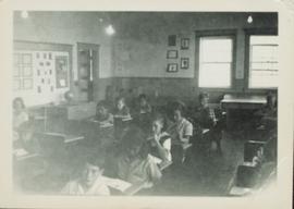
Photograph taken from the front of the classroom of Division II children in their desks. Handwritten annotation in pen on verso reads: “Studying.”
Some of the children from Division II standing for a group photograph in front of a wall displaying their work.
Image depicts debris left in residential area on Giscome, B.C. townsite. Map coordinates 54°04'16.7"N 122°21'55.1"W
Original photographic print included in "Northern Interior Forest Experiment Station: Report of Preliminary Investigations" by Percy Barr. Caption states: "Note openings made in stand."
Image depicts several unidentified concrete structures that are badly damaged and cracking, located on old mill site in Giscome, B.C. Map coordinates 54°04'18.0"N 122°22'04.7"W
Head on class photo featuring 28 students of grade 3, 4 and 5 posing for an outdoor photo in a field of grass. Wooden support for swing set visible to the left.
Overview of Giscome, BC showing built and natural landscape.
Handwritten annotation in pencil on verso: "Bunkhouse & Dining Room / Giscome BC".
Photograph of the front of Brown's General Store. Handwritten annotation in pen on verso reads: “Brown’s General Store. The wheelbarrow is for bringing the groceries and mail over from the train. Also if you buy a great quantity of things you wheel it home and then bring back the barrow (Taken on Sunday).”