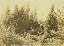
Print preview Close

Showing 3093 results

Archival description
3093 results with digital objects Show results with digital objects
2000.1.1.3.13.04 · Item · [before 1970]
Part of Cassiar Asbestos Corporation Ltd. fonds

Photograph depicts the Cassiar townsite behind shadow in foreground. Plantsite can be seen including the mill, dry rock storage building, tailings pile, and many other buildings. Mountains in background. Handwritten annotation on recto: "<- 13 1/2" ->". (This photograph was made into a promotional poster.)

Cayoosh Valley
2012.13.1.54.10 · Item · July 1977
Part of J. Kent Sedgwick fonds

Image depicts a view of Cayoosh Valley. Cayoosh Creek is visible in the bottom left corner of the image.

Cemetery
2012.13.1.78.21 · Item · 1982
Part of J. Kent Sedgwick fonds

Image depicts an individual crouching in an old cemetery located somewhere in the coastal forest on Haida Gwaii, B.C.

Cemetery
2012.13.1.6.157 · Item · Nov. 1980
Part of J. Kent Sedgwick fonds

Image depicts a cemetery at an uncertain location, possibly in Fort St. James, B.C.

Centre Street Prince Rupert
2009.7.1.251 · Item · ca. 1880-1920
Part of Archdeacon W. H. Collison fonds

Photograph of residents in motion on Centre Street in Prince Rupert. Buildings are visible on either side of the street and a railway track runs down the length of the road. Annotation on recto reads: "Centre Street, Prince Rupert, BC. 1664."

Chasm
2012.13.1.50.126 · Item · 1981
Part of J. Kent Sedgwick fonds

Image depicts a chasm full of trees at an unknown location.

Chasm
2012.13.1.50.128 · Item · 1981
Part of J. Kent Sedgwick fonds

Image depicts a chasm full of trees at an unknown location.

Chasm Wall
2012.13.1.50.127 · Item · 1981
Part of J. Kent Sedgwick fonds

Image depicts the wall of a chasm full of trees at an unknown location.

Chetwynd
2012.13.1.91.32 · Item · Nov. 1978
Part of J. Kent Sedgwick fonds

Image depicts a view of Chetwynd, possibly from Highway 97.

2012.13.1.65.07 · Item · May 1975
Part of J. Kent Sedgwick fonds

Image depicts a sign titled "Chilcotin Wildlife Management Area" somewhere near Riske Creek, B.C. It reads: "This trail has been provided by the Fish and Wildlife Branch in co-operation with Riske Creek Ranching Ltd., as access to the Chilcotin Wildlife Management Area. Please do not leave the the trail as the surrounding land is private property."