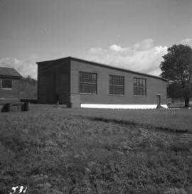
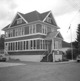
Photograph depicts the post office in Union Bay. It was a "Heritage" building and internally restored. Believed to have been built in 1908.
Photograph depicts the same person who owned the service station building electric generator house in Trout Lake. He also built an undershot water wheel that was driven by Lardeau Creek.
Photograph depicts a Ukranian Greek Orthodox church on the outskirts of Mission.
Photograph depicts a Ukranian Greek Orthodox church on the outskirts of Mission. A poster on its door stated that it been 50 years the church had been in Canada (1918-1968).
Photograph depicts a Ukrainian Greek Orthodox Church on 27th St. and 41st Ave. in Vernon, B.C. in the Okanagan.
Photograph depicts two steam whalers at North Vancouver awaiting breaking up.
Photograph depicts two Pacific Great Eastern locomotives at the North Vancouver depot. They are numbered 1002 and #585. Locomotive #1002 was built by the Montreal Locomotive Company. The view is looking east.
Photograph depicts two horse drawn freight wagons exhibited at Cache Creek, about 100 yards south of road junction, on the west side of Spences Bridge road.
Photograph depicts two grain elevators at Creston, BC. The Creston CPR yard lies behind the camera. The line is on a downgrade away from the camera, starting its descent to the valley bottom for Kootenay Lake. The grain elevators are a rare sight in BC.
Photograph depicts the rear view of two C.P.R. snowplows in the Coquitlam yards. The one in the forefront is #400790.
Photograph depicts the front view of two snow plows at the C.P.R. Coquitlam yards.
Photograph depicts a two bay locomotive shed of the round-house style at Alberni on Vancouver Island.
Photograph depicts two 3-truck Shay locomotives, #114 and behind her #115, belonging to the Railway Appliance Company at the Vancouver Wharves Ltd. in North Vancouver. They are in daily or weekly use. Both were built by Lima Locomotive Works Inc. Locomotive #114 was built in July 1928 as #3320 and #115 was built in October 1929 as #3344.
Photograph depicts a turntable located at the CN Junction in Kamloops. It was strpped of rails and decking prior to being lifted out of the well.
Photograph depicts a turntable pit located at the CN Junction in Kamloops, BC
Photograph depicts a turntable located at the CN Junction in Kamloops.
Photograph depicts a turntable at the CPR Penticton yard. The view is looking east.
Photograph depicts a turntable outside a disused roundhouse at the C.P.R. yards in Coquitlam. The turntable is still in use.
Photograph depicts a short tunnel through embankment of the former KVR. It was now exposed.
Photograph depicts the CPR Kettle Valley Railway in Myra Canyon. This is the southern portal of a 375 ft. long tunnel at about mile 85.7. Part of the bore is supported by timbers.
Photograph depicts the CPR Kettle Valley Railway in Myra Canyon. It shows the northern portal of a 277 ft. tunnel, located at mile 86.3.
Photograph depicts the CPR Kettle Valley Railway in Myra Canyon. This is the northern portal of a 375 ft. long tunnel at mile 85.7. It is lettered 1941 and there is 100 lb. rail dated 1947 at this location.
Photograph depicts a shed in Tulameen.
Photograph depicts a steam tugboat named "Master" owned by the World Ship Society (Vancouver Chapter). Photograph taken during Carnival and Regatta week in Vancouver.
Photograph depicts the tugboat "Island Sovereign" going to turn starboard after backing out from the dock. The view is looking southeast.
Photograph depicts the tugboat "Island Sovereign" moored at a dock in North Vancouver, 200 yards west of the Burrard Dry Dock, 2 days in service after refit.
Photograph depicts the tugboat "Island Sovereign" backing out at North Vancouver.
Photograph depicts the tugboat "Island Sovereign" with Burrard floating dock in the background.
Photograph depicts the tugboat "Gulf Margaret" with a Straits scow leaving the north arm of the Fraser River and entering the main river at New Westminster, travelling upstream. The tug belongs to the Gulf of Georgia Towing Company.
Photograph depicts a tugboat named "Gillking" docked at an unknown location.
Photograph depicts the tugboat "Brunette" at Westview Harbour, Powell River. It is registered in Vancouver.
Photograph depicts a small tugboat rescuing a motor cruiser that had been swept downstream in the Annacis Channel against a bridge, about 1.5 miles southwest of the Patullo Bridge, New Westminster.
Photograph depicts a tug towing gravel scow that was used to make concrete. Photograph taken at a BCER swing bridge.
Photograph depicts a small tug being completely renovated on a floating scow.
Photograph depicts a tug at Kingcome Navigation Dock in Vancouver Harbour.
Photograph depicts a truss bridge over the Salmon River near Kelsey Bay, North Vancouver Island.
Photograph depicts truss bridge over Lois River looking north. Bridge is about 2-4 miles north of Saltery Bay, leading to Powell River.
Photograph depicts an old truck that was found besides a logging yard and CNR trackage.
Photograph depicts a truck at the Teepoortens Truck and Equipment Rentals Ltd., located at 950 West 6th Ave. in Vancouver, BC
Photograph depicts the one and only service station that was in Trout Lake City. It had manual pumps as there was no distributed electricity in the village.
Photograph depicts the Trout Creek CPR bridge near Summerland, about 9 miles north of Penticton. It is about 620 ft. long and the creek is 240 ft. below it. It was part of the Kettle Valley Railway.
Photograph depicts the Trout Creek CPR bridge near Summerland, about 9 miles north of Penticton. It is about 620 ft. long and the creek is 240 ft. below it. It was first crossed by the Chief Engineer's train on October 25, 1913. The view is looking south east.
Photograph depicts Trout Creek Bridge of the KVR.
Photograph depicts a trestle on the ex CPR Coquihalla line of the Kettle Valley Railway. It is a famous view spot because the trestle has a waterfall behind it. It is now the only intact trestle on the line because even the very small ones were demolished after the line closed on 23 November 1959. It is located about mile 21.7 from Brookmere. The grade here is about 1 in 53.
Photograph depicts a trestle of the Great Northern Railway, main line to Blaine, curving towards the southwest from the south end of the New Westminster rail bridge.
Photograph depicts the trestle leading to the Canadian National Railway (CN) swing bridge across the north arm of the Fraser River. The view was taken on Lulu Island, looking northeast. The ground on each side of the trestle is peaty and springy when walked on.