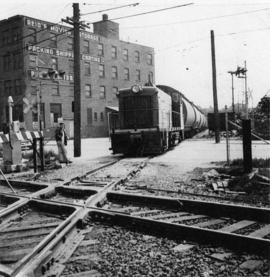
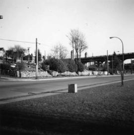
Photograph depicts a wooden arch supporting the sagging Georgia Viaduct in Vancouver, BCThe road in the foreground is Taylor Way.
Photograph taken at the Great Northern Railway connection from its terminal yards to its wharf on Vancouver Harbour or the connection with CPR. Image captured crossing Powell Street, looking southward, north of Glen Drive, Vancouver.
Photograph depicts the Great Northern Railway station on Main Street, Vancouver being demolished.
Photograph depicts a Goodyear airship travelling over Spanish Banks, Vancouver. It took part in the Abbotsford Air Show of 1971.
Photograph depicts a Goodyear Blimp cruising over the Centennial Museum near Sunest Beach, False Creek, Vancouver.
Photograph depicts a goodyear Blimp cruising over the Centennial Museum near Sunest Beach, False Creek, Vancouver. It came for the 1973 Abbotsford Air Show.
Photograph depicts the Grand Central Hotel at the intersection of Marpole Ave and Hudson St. in south Vancouver. The hotel was built in 1912 by J.J. Graver and run from 1913-1915. It re-opened in 1920 as a home for incurables (veterans). In 1937 it became the provincial infirmary and closed in May 1965.
Photograph depicts Granite Falls near the Wigwam Inn, Indian Arm, Vancouver, B.C.
Photograph depicts a B.C. Hydro Railway locomotive switching a flat car filled with construction equipment.
Photograph depicts a B.C. Hydro locomotive switching a flat car carrying a cat crane. Looking west with Granville road bridge in the background.
Plan depicts Granville Island industrial sites in False Creek, Vancouver. Shows revised trackage from 1955 annotated in colour by Davies.
Photograph depicts the rear of the Great Northern depot on Main St. in Vancouver, that is now demolished.
Photograph depicts the Great Northern Railway station in main street Vancouver. Image captured looking west with the CNR trackage to the left. Lifted track in the foreground used to be depot track. Visible are switchers and a sand car found behind them.
Photograph depicts a Great Northern Railway interchange curve to CPR tracks near Raymur Avenue/ Powell Street, Vancouver. Visible is a part of an export train, consisting of 11 (dead) General Motor locomotives hauled by a GNR switcher towards the Centennial Dock area. The process of destruction was to take place in Pusan by Korean National Railways.
Photograph depicts Raymur Avenue/Powell Street grade crossing. Image captured looking south at Burlington-Northern (former Great Northern Railway) trackage. Visible are the last 4 locomotives of an 11 locomotive (all dead) train hauled by a GN switcher. Export ship was to travel to Korean National Railways, Pusan, Korea.
Photograph depicts gulls at Lost Lagoon in Vancouver, B.C.
Photograph depicts the "Haida Chieftain" tug of the Kingcome Navagation Ltd. at their wharf in Vancouver.
Photograph depicts Hamilton St. in Vancouver. The photo was taken at the back of 1250 Homer St, but is actually on Hamilton St., looking east. The left-hand line is in regular use, but the siding on the right hand side is not.
Photograph depicts Hamilton St. in Vancouver, looking northeast.
Photograph depicts Coal Harbour in Vancouver. The photo is facing land fill with stone on the tidal side. The site is for the first block of the Harbour Park Development Ltd. high rise apartments.
Photograph depicts the Harbour Park Development site in Coal Harbour, Vancouver. Taking rock from the scow to face fill with anti-erosion material. The site is for new high rise apartments at the edge of Stanley park between Georgia St. and the sea.
Photograph depicts the headquarters and general offices of the National Harbours Board in Vancouver, B.C., located at the foot of Dunlery St.
Photograph depicts the H.M.C.S. Beacon Hill at English Bay in Vancouver during the maritime festival.
Photograph depicts HMCS Discovery Naval Reserve headquarters in located on Deadman's Island, Vancouver.
Photograph depicts the H.M.C.S. Mackenzie in English Bay in Vancouver during the maritime festival.
Photograph depicts the H.N.C.S. Mackenzie in English Bay in Vancouver, during the maritime festival.
Photograph depicts the H.M.C.S. Saskatchewan in English Bay, Vancouver during the maritime festival.
Photograph depicts a home at 1310 Comox St. in Vancouver, B.C. View is of the east side of the house, facing Jervis St.
Photograph depicts a home located at 1459 Robson St., at the northeastern intersection of Robson and Nicola, in Vancouver B.C.
Photograph depicts the 1000 Beach Ave. block with dogwood rose tree in bloom at the left of the photo.
Photograph depicts homes on 1000 Beach Ave., looking northeast.
Photograph depicts the homes on 1000 Beach Ave. in Vancouver, B.C.
Photograph depicts homes on 1000 Beach Ave., looking northeast.
Photograph depicts homes on 1000 Beach Ave., looking northeast. House #1053 on the left has been demolished at this point and then set on fire one night by kids.
Photograph depicts homes on 1000 Beach Ave. in Vancouver, B.C.
Photograph depicts home at #1053 Beach Ave., which is now fully demolished.
Photograph depicts the ongoing wrecking of house #1053 on Beach Ave.
Photograph depicts house at #1053 Beach Ave. in Vancouver, B.C. Dan Davies was a resident at one time.
Photograph depicts a house fire in West End of Vancouver.
Photograph depicts a house on 10th Ave., Vancouver.
Photograph depicts a house that had been pushed on its side by a bulldozer.
Photograph depicts a house that at the moment was being pushed up on its side by a bulldozer.
Photograph depicts one of the four houses on the corner of Barclay and Nicola. It was being demolished to make way for high rise apartments.
Photograph depicts a house being gutted, prior to demolition.
Photograph depicts one of four houses that were being gutted and demolished to make way for a concrete high rise apartment block. Built circa 1905.
Photograph depicts a house that had a "sold" notice on it and was partly demolished. Up to the date the photograph was captured, this block on Beach Ave. was the sole remaining one to have only houses on it, as opposed to a mixture of houses and apartment blocks, or blocks only.
Photograph depicts a house on the southern edge of Chinatown.