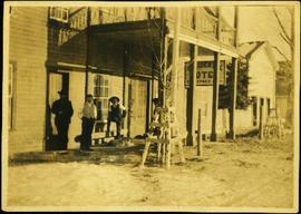
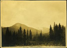
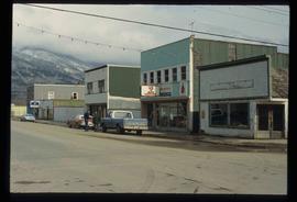
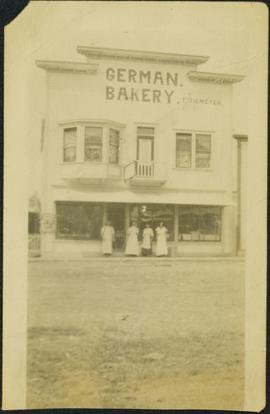
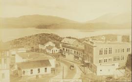
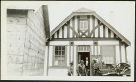
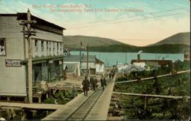
Image depicts the Pine Tree Restaurant in Atlin, B.C. It is possibly part of the Atlin Museum.
Image depicts an aerial view of Pine Centre Mall and Masich Place Stadium in Prince George, B.C.
Image depicts Pine Centre Mall in Prince George, B. C. Map coordinates 53°53'53.2"N 122°46'36.4"W
Image depicts the Prince George Multiplex.
Jones stands behind microphone in log building. Photo taken during tour with Crowder Communications.
Photograph depicts buildings and signage on either side of dirt road. Unidentified man stands on far left, Atlin Lake and mountains can be seen in background.
Hand inscribed annotation on recto of photograph reads: “Pearl St., Atlin, B.C. Aug. 1899. A.C. Hirschfeld, No.74”.
Overhead view of a block of business and harbour buildings in Prince Rupert BC. The "Savoy Hotel" is visible in the foreground. Printed annotation on recto reads: "Part of Business Section & Harbour. Prince Rupert B.C. F. Button Photo Pr. Rupert No. 494."
Photograph of many loaded pack horses in front of the "McMillan Transfer Company." Printed annotation on recto reads: "Pack-Train At Bitter-Creek Hughes 116."
Postcard overview of several identifiable storefronts built amongst the rocky outcrops of Prince Rupert. Printed annotation on recto reads: "Prince Rupert BC."
Elevated street view of Fulton Street in Prince Rupert, BC. City Hall is in the left foreground. Hills and water are visible in the background. Printed annotation on recto reads: "Prince Rupert. B.C."
Wide angle photograph of many buildings scattered in a clear cut area. Foreground shows several businesses, including "Kelly Carruther's Supply" and "Prince Rupert Hardware and Supply Co." Some remaining forest is visible in the background. Annotation on recto reads: "Prince Rupert, BC 1659."
Overhead view of many commercial buildings in Prince Rupert, BC. Printed annotation reads: "Prince Rupert, BC."
Image depicts the original bank building in Wells, B.C.
Photograph depicts river between opposite shore and rock landings in foreground. Mountaintops visible in background. Handwritten photo caption on verso and recto of this photograph reads: "Opening of the River above the Grand Canyon".
Item is a photograph of officials attending the June opening of the Crestwood Forest Industries pulp mill in Cranbrook, until that time the only pulp mill built without benefit of a Pulp Harvesting Area (PHA) license to assure timber supply. Mr. Williston is on the left.
Typed annotation on recto: "Old Hudson Bay Company storhouse [sic] at Fort St. James, B.C." Cow grazing in front of a large, white, two-story building with a ladder on its roof. Wood fence, smaller second building, and forest hillside can be seen in background.
Photograph depicts car on road, rocky hillside in background. Typed caption beneath this photograph: "The official car of the Government Agent, Atlin". Handwritten annotation on recto of photograph: "Uncle Bert's car as Government Agent".
Photograph depicts group of 12 men standing on steps at back of main office. Front row: Jack Berry, Mickey Dopson, Andre Beguin, Fred Murray. 2nd row: Dick Stevens, Rene Pasiaud. Third row: Craigie Hood, Alex Powell. Back row: Dr. Charles Cobb MD, Peter Davies, Chuck Caron (holding paper), Bill Johnston. Berry and Dopson are wearing hard hats. Windows and doors of office building in background. Stamped annotation on recto of photograph: "Munshaw Colour Service Ltd. OCT 24 1958".
Photograph depicts four men standing under balcony of hotel near other buildings on street. Trees line the street, with protective structures built around their trunks. It is speculated that one of these men may be Mr. A. K. Bourchier. Handwritten annotation on recto of photograph: "As you were".
Photograph depicts two connected buildings; the building on the left is possibly the theatre, other building with sign that reads: "The Nechaco (sic?) General Stores." Boardwalk with people and unpaved street in foreground.
Handwritten annotations on verso read: “The Northland mess - Basford + Long - sell out to Bennett”.
Photograph depicts mountains in background behind forest trees. River barely visible behind bushes at bottom of photo. Handwritten photo caption on verso and recto of this photograph reads: "On the Clearwater."
Group of unidentified individuals sit at tables in background, and one man stands in doorway.
Handwritten annotations on verso read: “Return to Tom,” and “Iona presenting memorial plaque to Mrs. Nathan Barton at NCDC Meeting, Prince Rupert / Sept. 77.”
The pair stands among piles of boxes in what appears to be a warehouse.
Handwritten annotations on verso read: “Northland Navigator Fallout rotten meat,” “(8)”and “Iona and Werner Funk, Queen Charlotte City, August 1977”Charlotte City, August / 77.”
The pair stands among piles of boxes in what appears to be a warehouse.
Handwritten annotations on verso read: “lost election thanks to Otto Longs Transport decision to OK subsidy to North Coast Freight shipping,” and “Iona and storekeeper Werner Funk discussing freight costs, Queen Charlotte City, August / 77.”
Photograph depicts a crowd of men standing under balcony of three story hotel. Handwritten annotation on verso of photograph: "South Fort George, B.C."
Photograph depicts a line of men standing on rocky shore and holding a long rope between them, while men on scow float close to shore in distance. Trees on opposite shore in background. Handwritten photo caption on verso and recto of this photo reads: "in the Grand Canyon."
Photograph depicts a line of men standing on opposite shore and holding a long rope between them, while men on scow float close to shore in distance. River water in foreground, trees on shore in background. Handwritten photo caption on verso and recto of this photograph reads: "In the Grand Canyon."
Photograph depicts four men in front of BC Government Liquor Store. Bulldozer and unidentified building in foreground. See also items 2009.5.2.76 & 2009.5.2.77.
Photograph depicts three men in front of BC Government Liquor Store, one standing in doorway. Bulldozer in foreground, fence and trees in background. See also items 2009.5.2.75 & 2009.5.2.77.
Three men stand under deck of three story hotel. Handwritten annotation on verso of photograph: "Empress Hotel South Fort George, B.C.", on recto: "according to Mrs [illegible] Williams this Hotel burned down New Years 1914 and the owner collected insurance & moved to Anchorage Alaska. (smell of kerosene)", "Boucher [sic]".
Photograph depicts four men standing in front of small log cabin with sod roof. It is believed that these men are also featured at Ah Yee's in item 2009.5.3.16. A man believed to be Meikle sits in window of cabin. Forest in background. Handwritten annotation on recto of this photograph reads: "Meikle's Cabin mouth of Clearwater".
Image depicts a street in McBride, B.C.
Image depicts a machine shop somewhere in McBride, B.C. The sign above the door reads "McBride Air Cooled Engine Services Ltd."
Image depicts the Elks Hall in McBride, B.C.
Image depicts a street in McBride, B.C. One of the store signs reads "Allied Hardware."
Image depicts an abandoned building on the corner of a street in McBride, B.C.
Image depicts an abandoned building on the corner of a street in McBride, B.C. The faded letters on the side read: "McBride Trading Co. Mens Wear, Drugs, Equipment."
Image depicts McBride, B.C.
Buildings in foreground, waterscape in midground, trees and snowcapped mountains in background. Printed annotation on recto reads: “Marine and Fisheries Digby Island Prince Rupert B.C. McRae Bros”
Street view of a large crowd of veterans marching down a street in Prince Rupert. Printed annotation on recto reads: "3." Handwritten annotation on verso reads: "Prince Rupert: Nov. 11. 1940. Main St."
Photograph of a marching band performing down a wooden road. Spectators can be seen in the foreground and various businesses are in the background. Annotation on recto reads: "Prince Rupert BC."
Image depicts the gas station at Manson Creek, B.C.
Photograph depicts one man and three woman standing in front of shop windows of three story building with the sign "GERMAN. BAKERY. F. TIEMEYER" A window nook and small balcony extend from second floor. Road in foreground. Handwritten annotations on recto of photograph: "Main Building 30 x 32. Lean to for Bake Shop. Food cellar. Five Food Rooms upstairs. Electric lights throughout entire house. Burned badly Jan 15 - 9 45 PM 1969. Was originally moved from South."
Street view photograph of buildings along the dirt road of Main Street in Smithers, B.C." Printed annotation on recto reads: "Main St. Smithers B.C." Handwritten annotation in pen on verso reads: "Town 7 miles from my place."
Hand coloured photo of Main Street in Prince Rupert, with various tents and buildings on either side of the wooden road. Printed annotation on recto reads: "Main Street, Prince Rupert, B.C. : On comparatively Level Line London to Yokohama." Artist's mark on lower right corner reads: "104,035 J.V."
Image depicts several buildings along the main street in Stewart, B.C.
Image depicts the main street of Stewart, B.C.
Image depicts numerous vehicles parked outside a building with a sign which reads "Mackenzie Centre;" it is possibly the mall in Mackenzie, B.C.
Image depicts numerous individuals inside a mall in Mackenzie, B.C.