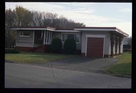
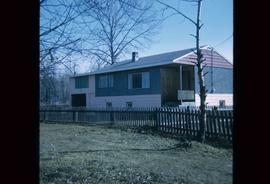
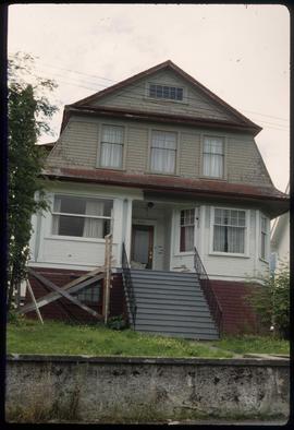
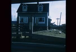
The item is a photograph that depicts the front of a beige house at 321 North Moffat Street.
The item is a photograph that depicts the backside of a beige house at 321 North Moffat Street.
Image depicts a view of 3rd Avenue with the Columbus Hotel prior to the fire that destroyed it in 2008.
Image depicts the south side of 3rd Ave in Prince George, B.C.
Image depicts the Europe Hotel on the south side of 3rd Ave in Prince George, B.C.
Image depicts a view of the corner of 3rd Avenue and Brunswick Street in Prince George, B.C.
The photograph depicts a duplex on the lot located at 4084 Old Cariboo Highway outside of Prince George, BC. The house is white stucco with a sheet metal roof.
The photograph depicts a duplex on the lot located at 4084 Old Cariboo Highway outside of Prince George, BC. The house is white stucco with a sheet metal roof. The duplex on the right side has Halloween decorations on the door and in the window.
Image depicts 411 Patricia Boulevard in Prince George, B.C.
The photograph depicts a two-story white house at 4486 Zilkie Rd. Prince George. Annotation on reverse side of photograph states, "Zilkie Rd."
The photograph depicts a white duplex on Marston Road. The address on the duplex reads 4555.
The photograph depicts a white duplex on Marston Road. The addresses on the duplex read 4603 and 4633. A blue Chevrolet truck is parked next to the building.
The item is a photograph that depicts the back of veteran housing at 510 Douglas Street. House is on the south east corner. Beige stucco house with brown roof.
The item is a photograph that depicts the front of veteran housing at 510 Douglas Street. House is on the south east corner. Beige stucco house with brown roof.
The item is a photograph that depicts the side of veteran housing at 510 Douglas Street. House is on the south east corner. Beige stucco house with brown roof.
This item is a photograph of 575 Quebec Street, Prince George. Building is white, pink and blue. Telus tower can be seen in the background.
The item is a photograph depicting 5th Avenue looking West from Vancouver Street. Annotations on the back states, "Monday 11:00 am - 29 Apr. /91 5th Ave looking W. from Vanc."
The photograph depicts a two-story white house at 7295 Cummings Road outside of Prince George. Annotation on reverse side of photograph states, "7295 Cummings Rd, relocated 1976."
The item is a photograph depicting the side view of a white house located at 886 Vancouver Street, Prince George.
The item is a photograph depicting the garage located at the back of 886 Vancouver Street, Prince George.
The item is a photograph depicting the back of a white house and garage located at the back of 886 Vancouver Street, Prince George.
The item is a photograph depicting the front view of a white house located at 886 Vancouver Street, Prince George.
The item is a photograph depicting the side view of a green coloured house at 983 Vancouver Street in Prince George.
Image depicts a bear, possibly a grizzly. The location is uncertain.
Image depicts a truck on a bridge, possibly crossing over the Peace River.
Image depicts a building somewhere in Wells, B.C. There is a sign in one window which reads "Lon Oddfrey Insurance Realty LTD."
Image depicts a camper and a man and woman at an uncertain location, possibly somewhere near Meldrum Creek, B.C. The woman in the image is Sue Sedgwick.
Image depicts a church in Wells, B.C.
Image depicts a church at an uncertain location.
Image depicts the interior of a classroom at an uncertain location.
Image depicts a cow at an uncertain location.
Image depicts a creek somewhere near Bralorne, B.C.
Image depicts what appears to be a ferry crossing a river at an uncertain location.
Image depicts a stretch of highway, possibly Highway 29 or 97.
Image depicts a horse near a camper somewhere in Quesnelle Forks, B.C.
Image depicts a horse on Cottonwood Island.
Image depicts a hotel in what appears to be a small community, possibly an outlying area of Bralorne, B.C.
Image depicts a house at Island Cache.
Image depicts a house at an unknown location. It is possibly an old, Australian styled home.
Image depicts a house which is possibly in Prince Rupert, B.C.
Image depicts a house in Island Cache.
Image depicts a house in disrepair, and possibly abandoned, in Island Cache.
Image depicts a house somewhere in Prince George, B.C.