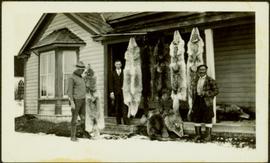
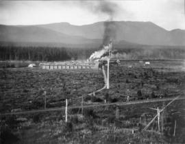
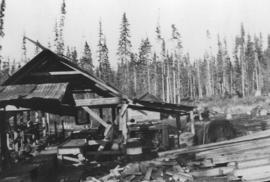
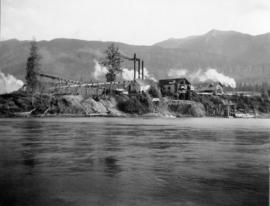
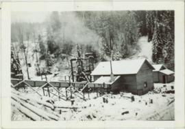
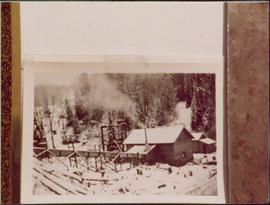
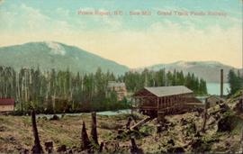
Hand coloured photo of a clearing in Prince Rupert with a sawmill in the distance. Printed annotation on recto reads: "Prince Rupert, B.C. : Saw Mill Grand Trunk Pacific Railway." Artist's stamp in the lower right corner reads: "103112 J.V."
Photograph depicts Sarah walking amongst people on sidewalk lined with cars and tall buildings. Power lines cross midground. Photograph believed to have been taken by street photographer. Handwritten annotation on recto of photograph: "Sarah Glassey."
The pair walks on sidewalk, wearing hats and fur lined coats, Glassey on left. Car, power lines, and tall buildings stand in background. Photograph believed to have been taken by street photographer.
Photograph depicts a safety sign in a mill work area that reads, "You can bet your life on safety."
Photograph depicts a Ruston steam roller owned by Gary Wellburn in Duncan, BCIt was previously owned by the Oak Bay municipality.
Photograph depicts the large bearing cups of one of the Ruston Hornsby diesel engines that turned the generators in the power house on the Cassiar plant. Engine believed to be under repair. Electric panels in background.
Photograph depicts the large bearing cups of one of the Ruston Hornsby diesel engines that turned the generators in the power house on the Cassiar plant. Engine believed to be under repair. Electric panels and unidentified individual in background.
Photograph depicts the large bearing cups of one of the Ruston Hornsby diesel engines that turned the generators in the power house on the Cassiar plant. Engine believed to be under repair. Saw horse, machinery, and electric panels in background.
Photograph depicts an unidentified First Nations man standing to right of wolf pelts that hang from eaves of house in Atlin, B.C. Stewart and Glassey stand on left, Glassey wearing a suit and tie. Typed annotation on recto of photograph: "Wolf pelts from Teslin, B.C.", handwritten: "Ron Stewart is policeman." See also items 2009.5.2.67 & 2009.5.2.68.
Image depicts a river full of logs, somewhere near Bralorne, B.C.
Photograph depicts the reverse view of a steam donkey at Sayward near Kelsey Bay on North Vancouver Island.
Photograph depicts Red Mountain Lumber Company mill owned by Roy Spurr in Penny, BC in 1929. Scattered all around the mill are the remnants of the previous coniferous forest that was destroyed in the Penny Fire that occurred 2 years earlier.
Photograph depicts the Peden Hill sawmill, after the mill was rebuilt after the first mill burnt down in 1941. The first mill was operated by steam; the second mill was powered by a diesel-powered motor.
Item is a photograph of Mr. Williston with a group of men at a logging operation, exact location unknown. Mr. Williston is second from the right.
Photograph depicts a ramp and boats at the Prince Rupert marina, including the "Northern Dawn".
Photograph of a line of rail cars along a track next to a blasted pile of rubble. Printed annotation on recto reads: "Photo by McRae Bros. Prince Rupert." Handwritten annotation on verso reads: "Hello Charly. I have been dead for 2 month and just woke up tell the folks out home I am doing[??] fine. don't know when I will be down again Remember me to the good little woman, and weave[??] all Well. you're[??] friend Stan C." Postcard is addressed to: "Mr. Charles Chislett 96 Colonist Printing Co. Broad Street Victoria B.C." Verso is affixed with a one cent Canadian stamp. Postmark reads: "Prince Rupert B.C. [illegible date]."
Photograph depicts two wooden buildings in a snow covered forest environment. Photo is adhered to paper backing, upon which handwritten annotation on recto reads: “Quesnelle Quartz mining Company Hixon, B.C. Taken in mid nineteen thirties. Powerhouse from rear. Present day (1973) logging road would run through powerhouse at immediate rear of it at which you are looking. Tom Marsh Box 156 Squamish BC V0N 3G0 December 1978”
Photograph depicts two wooden buildings in a snow covered forest environment. Photo is adhered to paper backing, upon which handwritten annotation on recto reads: “Quesnelle Quartz Mining Co. Hixon BCTaken in mid 1930ies. Power house from rear. Present day (1973) Logging road would run through powerhouse at immediate rear of it at which you are looking. Tom Marsh Box 150 Squamish BC 1978.12”
Annotated overview of the Quesnel Quartz Mine Camp, with buildings numbered and a corresponding legend provided. Annotation on recto of photograph states: "1. BRIDGE OVER CREEK 2. BLACKSMITH SHOP 3. POWEROUSE 4. HEADFRAME OVER 200' SHAFT 5. OFFICE 6. WATER TANKS FROM POWERHOUSE 7. BUNKHOUSE 8. TRUCK 9. COOKHOUSE BEHIND #6 CANNOT BE SEEN" Additional annotation associated with photograph states: "We were always able to find the cookhouse even though hidden in this picture. Taken about 1935 by Russell Ross Supt. Quesnel Quartz Mine"
Image depicts numerous wood piles near the sawmill somewhere in Quesnel, B.C.
Image depicts a sawmill somewhere in Quesnel, B.C.
Photograph of a small vessel on the ocean with a dock and harbour buildings in the foreground. Tents and piles of lumber can be seen among the buildings. Annotation on recto reads: "The Wharf, Prince Rupert, BC. 1657." Printed annotation on verso reads "The Wharf, Prince Rupert, BC J. Howard A. Chapman, Victoria. BC. 1657."
Photograph depicts a shipping terminal in Prince Rupert. Shipping containers are in the distance.
Photograph depicts a shipping terminal in Prince Rupert. The ocean is visible in the background.
Photograph depicts a shipping terminal in Prince Rupert. The photo is taken from a hill, and several shipping containers sit in the almost empty lot. The ocean is visible in the background.
Photo of entire ship building plant, including several vessels in the foreground. Hills are visible in the background. Annotation on recto reads: "Prince Rupert Ship Repair and Ship Building Plant. Prince Rupert BC. Frank E Kirby, William T Donnelly, Engineers. 17 Battery Place. NYC."
Photograph of many fishing boats in a harbour. Printed annotation on recto reads: "Prince Rupert Halibut Fleet landing 500,000 LBS. WWW."
Photograph depicts 6 Men on a fishing boat with water in the background. Equipment on the boat is covered with a very thick layer of ice. Printed annotation on recto reads: “Rupert Fishing Boat After Stormy Trip Jan 1916”. Handwritten annotation in pencil on verso reads: “Rupert Fishing Boat , A Stormy Trip”.
Image depicts the Prince George Sawmill from the Northwood Bridge.
Image depicts Prince George Sawmill taken from across the Nechako River looking southwest. Map coordinates 53°56'00.0"N 122°44'29.7"W
Image depicts a sawmill in Prince George, B.C.
Image depicts Prince George from University Way, with the P.G.I pulp mill in the distance.
Image depicts Prince George from University Way, with the P.G.I. Pulp Mill in the distance.
Image depicts Prince George, possibly with the Northwood Pulpmill in the background.
Photograph depicts Trudeau walking outside with a group of men and women on his tour of the Cassiar operation.
Photograph depicts Trudeau standing outdoors with three unknown RCMP constables. Cassiar valley is in the background.
Photograph depicts Trudeau standing outside with a group of men.