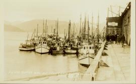
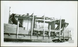
Photograph depicts an oxen powered log carrier with wheels that are approximately 10 feet in diameter. It is at Pioneer Park and Museum near Totem Lake, 3 miles north of Yahk and 30 miles east of Creston.
Photograph of a large waterfront factory. Annotation on recto reads: "Pacific Mills, Ocean Falls, BC. No. 2935."
Photograph depicts the lumber yard at Peden Hill sawmill, likely after the fire that burnt down the first mill at that location.
Image depicts an aerial view of areas that have been used for logging around Prince George, B.C.
Image depicts an aerial view of the Ahbau area somewhere near Prince George, B.C.
Photograph depicts a two men standing on piles of whale bones at a whaling station. Annotation on verso of photograph states: "Pile of whale bones, Whaling station, Vancouver Is."
Photograph depicts the Pinchi Lake mercury mine as seen from the water. Some buildings appear to be under construction. Handwritten annotation on verso reads: "Pinchi Lake min (mercury).
Photograph depicts a portion of the pit in foreground at the Cassiar mine. Crushing plant visible in centre below base of West peak. Footwall road in midground, mine valley in background. Building near trucks at top of pit was called the "shifter shack," where crews were relieved or dropped off for work.
Photograph depicts the pit head refuse at Extension Coal Mine, 5 miles southwest of Nanaimo. It worked between 1901 and 1931.
Photograph depicts a portion of the Cassiar pit in right foreground. Crushing plant visible to left of pit, West peak visible in right background. Mountain range can be seen in distance.
Photograph depicts an unidentified man mining in rocky area, trees and hills in background. Handwritten annotations on verso of photograph: "PLACER MINER WSHING FOR GOLD FINDLAY RIVER BC", "PHOTO WWW".
Two men stand below a large upright hose that is spraying a powerful stream of water against the side of a rocky hillside. Annotation on verso of photograph states: "Placer Mining Hixon (Hungry Thirties) This picture taken on top off Hill Across from Ques. Qarts. Maybe 800 Ft. west of Quarty There pictures taken approx 45 years ago Your friend(?) Box 156 Squamish B.C. Dec. 19/78"
Photo is adhered to paper backing, upon which handwritten annotation on recto reads: “Placer mining Hixon B.C. Hungry 30ies. This picture taken on top of hill across from Quesnel Quartz Mine maybe 800 ft west of Quartz taken approx 45 yrs ago (1933) 1978.12.19”
Five unidentified miners pose for a photo. Logs and wood scraps in foreground, forest in background.
Printed annotation on recto of photograph: "PLACER MINING, ATLINTOD RIVER, ATLIN, B.C. A.C. HIRSHFELD NO. 753."
Image depicts a pulp mill in Port Edward, B.C.
Photograph depicts boy on bike, and group of men in front of hull on trailer pulled by truck. Railway tracks visible on right, forest and hills in background.
Photograph depicts a crane behind rail tracks on left, main hook block suspended above boat hull resting on railway flatbed. Group of men in foreground, one man on hull. Trees and hills in background.
Photograph depicts boat hull resting on trailer flatbed pulled by truck. Trees and hills in background.
Photograph depicts middle section of boat hull on flatbed, trees in background.
Photograph depicts large square model of the new mill building that was built at the Cassiar plant site in 1970. Model is displayed on platform draped with green material. Machinery modeled inside the structure is colour-coded.
Handwritten annotation on recto of photograph: "POURING RIBS JUNE 29/64." Photograph depicts construction workers on large wooden framework structure extending from base of crusher building. Ladders stand parallel to structure against mountainside. The boom of a crane is visible in foreground. Miscellaneous construction equipment and materials throughout.
Photograph depicts Trudeau wearing a white hardhat with his name on the front.
Photograph depicts Trudeau being shown the Cassiar mine from outside by Cassiar employees
Photograph depicts Trudeau standing outdoors and speaking with an unknown man.
Photograph depicts Trudeau standing outside with a group of men.
Photograph depicts Trudeau standing by trees and brush with a group of men on his Cassiar tour.
Photograph depicts Trudeau standing outdoors with three unknown RCMP constables. Cassiar valley is in the background.
Photograph depicts Trudeau walking outside with a group of men and women on his tour of the Cassiar operation.
Image depicts Prince George, possibly with the Northwood Pulpmill in the background.
Image depicts Prince George from University Way, with the P.G.I pulp mill in the distance.
Image depicts Prince George from University Way, with the P.G.I. Pulp Mill in the distance.
Image depicts a sawmill in Prince George, B.C.
Image depicts the Prince George Sawmill from the Northwood Bridge.
Image depicts Prince George Sawmill taken from across the Nechako River looking southwest. Map coordinates 53°56'00.0"N 122°44'29.7"W
Photograph depicts 6 Men on a fishing boat with water in the background. Equipment on the boat is covered with a very thick layer of ice. Printed annotation on recto reads: “Rupert Fishing Boat After Stormy Trip Jan 1916”. Handwritten annotation in pencil on verso reads: “Rupert Fishing Boat , A Stormy Trip”.
Photograph of many fishing boats in a harbour. Printed annotation on recto reads: "Prince Rupert Halibut Fleet landing 500,000 LBS. WWW."
Photo of entire ship building plant, including several vessels in the foreground. Hills are visible in the background. Annotation on recto reads: "Prince Rupert Ship Repair and Ship Building Plant. Prince Rupert BC. Frank E Kirby, William T Donnelly, Engineers. 17 Battery Place. NYC."
Photograph depicts a shipping terminal in Prince Rupert. Shipping containers are in the distance.
Photograph depicts a shipping terminal in Prince Rupert. The ocean is visible in the background.
Photograph depicts a shipping terminal in Prince Rupert. The photo is taken from a hill, and several shipping containers sit in the almost empty lot. The ocean is visible in the background.
Photograph of a small vessel on the ocean with a dock and harbour buildings in the foreground. Tents and piles of lumber can be seen among the buildings. Annotation on recto reads: "The Wharf, Prince Rupert, BC. 1657." Printed annotation on verso reads "The Wharf, Prince Rupert, BC J. Howard A. Chapman, Victoria. BC. 1657."
Image depicts a sawmill somewhere in Quesnel, B.C.
Image depicts numerous wood piles near the sawmill somewhere in Quesnel, B.C.