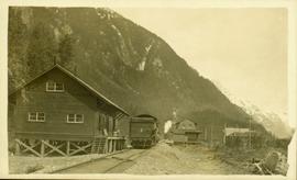
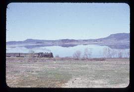
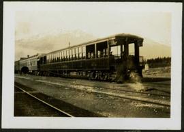
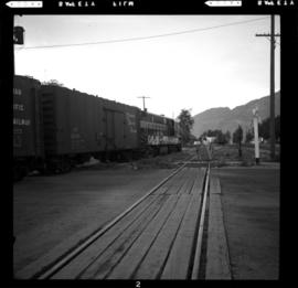
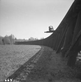
Photograph depicts the last few cars of a train, with men visible in the caboose. Tracks cross the foreground, trees and mountains in background. Handwritten photo caption below photograph reads: "Jasper Station, Alberta."
Photograph depicts a train at the Cowichan Valley Forest Museum on Vancouver Island.
Photograph depicts a train at the Great Northern Railway Station in Vancouver, B.C.
Photograph depicts a train car backing up on the west side of the C.N. station in Hope. It is part of the West Coast Railway Association trip on August 8, 1964.
Photograph depicts two (out of three) cares lettered Morrissey, Fernie and Michel Railway, from whence they came in 1964. The worked on the Coal Creek line to Fernie until about 1959. They are on display at Heritage Park in Calgary.
Side perspective photograph of a train stopped at the Stewart railroad station. Another train can be seen arriving in the distance.
Photograph of a train passing through a forested area.
Image depicts what is possibly a train fuelling station at the GTP Roundhouse in Prince George, B.C.
Image depicts what is possibly a train fueling station at the GTP Roundhouse in Prince George, B.C.
Image depicts a train in the interior of the GTP roundhouse in Prince George, B.C.
Image depicts a train in the GTP roundhouse in Prince George, B.C.
Photograph depicts a Pacific Great Eastern Railway locomotive in deep snow. A person, possibly a woman, stands near the train as snow continues to fall. The location is unknown, but may be Alta Lake or Squamish.
Subseries contains textual material relating to station names and locations, road crossings, and the movements of trains.
Subseries contains textual material relating to the movements of trains.
Subseries contains material related to BC Rail train movements and operations. Employee time tables and operations forms are included within.
Photograph depicts a train near Moyie on the CPR line. The end of the train was drawn by head end locomotive #6047. The train was westbound to Nelson, located at about mile 13 on the Nelson Subdivision, which starts at Cranbrook.
Photograph depicts the rear end of the first train of the 1994 season for the Rocky Mountaineer Rail Tours at the CN Downtown Depot in Kamloops.
Photograph of a train passing over a bridge near Stewart, BC. Printed annotation on recto reads: "103 Stewart BC."
Image depicts a train on the Hansard Bridge across the Fraser River looking west. Map coordinates 54°04'37.7"N 121°50'39.9"W
Postcard depicts a train oustide a snowshed in Glacier, BC. It was thought the view was looking south with Glacier Hotel in the middle distance at the head of the 180 degree loop. Outside trackage was built alongside sheds in the summit area of Rogers Pass.
Photograph depicts the engine and first two cars of a railway train in left foreground. Water crosses midground, hills stand on opposite shore in background. Handwritten annotation on recto of mounted slide reads: "Lejak [sic] & Fraser Lake in [?]" See also item 2006.20.1.196 for image featuring similar content.
Image depicts a train and several unidentified individuals who appear to be waiting for it as it passes through Sinclair Mills, BC.
Photograph depicts the junction station of the Esquimalt and Nanaimo Railway at Parksville on Vancouver Island. The view is looking south.
Image depicts a train track and several buildings in an unknown location.
Front view of a stretch of railroad passing through a forested area. Photograph shows a mountain in the background.
Image depicts a train transporting wood planks, possibly in Prince George, B.C.
Photograph of a train traveling through Prince Rupert. Several people are gathered on the dock and around various buildings. Two small vessels are docked in the harbour. Annotation on recto reads: "Prince Rupert, Waterfront. Allen Photo May '4."
Image depicts a train carrying logs somewhere in Prince George, B.c.
Image depicts a train and a group of unknown individuals at the GTP roundhouse in Prince George, B.C.
Image depicts several trains at the Giscome mill site in Giscome, B.C. Map coordinates 54°04'19.7"N 122°22'04.7"W
Image depicts trains at the Grand Trunk Pacific railway roundhouse in Prince George, B.C.
Photograph depicts trains switching at Osoyoos, BC.
Subseries consists of correspondence and accompanying informational material related to Transport Canada and transportation issues in general, especially those that pertain to northern BC. Records include news releases, newspaper and magazine clippings, maps, meeting minutes, reports, memoranda, newsletter, pamphlet and brochures, reference material, and speeches from the Minister of Transportation and others. Includes correspondence regarding marine transportation, such as amendments to the Canada Shipping Act (Bill C-61), the Pacific Rim Access Project for a port at Kitimat, search and rescue services, marine pollution, harbour and marina developments, the Prince Rupert Fairview Terminal, and ferry transportation and subsidies; land transportation, such as highway maintenance, northern BC bus routes and public transportation, the Motor Vehicle Safety Act (Bill S-8), pedestrian safety, highway and bridge construction, and improvements to the Yellowhead Highway; rail transportation, such as closure of agencies, rail subsidies, freight rates, passenger train services, and railway companies (BC Rail, CNR, and CPR); and air transportation, such as the decentralization of Air Canada, the Air Canada strike, the use of government aircraft, pilot and air charter licenses, the Queen Charlotte Islands air transportation subsidy agreement, complaints regarding service, and BC airports.
Subseries consists of material collected and created by Kent Sedgwick for research regarding transportation. Includes notes and research on airplanes, specifically Prince George aviation and the Junkers aircraft named "The City of Prince George"; highway transportation; the Grand Trunk Pacific Railway; ferry boat service including the Fraser River Fort George ferry, the Isle Pierre ferry, and the Miworth ferry; the Pacific Great Eastern Railway line; the British Columbia Railway; and the Canadian National Railway. Also includes essays and typed documents on railway history in Prince George.
Photographs within this file pertain to modes of transportation and transportation routes (including construction, surveying and traveling).
Image depicts two unidentified individuals examining a thick log still attached to the machine that cut it down. It is located somewhere in Prince George, B.C.
Large tree trunk and smaller saplings silhouetted against Summit Lake, forest visible on opposite shore. Handwritten caption beside this photo reads: "Sumit Lake."
Image depicts a green car among some trees on Cottonwood Island.
Photograph depicts a trestle bridge for road traffic leading to the Second Narrows Bridge in Vancouver, BCThe shot is taken from the south bank.
Photograph depicts the CPR Kettle Valley Railway in Myra Canyon. This is one of the nine wooden trestles between mile 85 and mile 86.4
Photograph depicts the CPR Kettle Valley Railway in Myra Canyon. It shows the a wooden trestle fitted with a sidewalk, which at 434 ft. long is the longest one in the canyon. It is located at mile 85.9. The view is looking south.
Photograph depicts the CPR Kettle Valley Railway in Myra Canyon. The view is looking north at the trestle located at mile 85.4
Photograph depicts the CPR Kettle Valley Railway in Myra Canyon. It shows the a wooden trestle fitted with a sidewalk, which at 434 ft. long is the longest one in the canyon. It is located at mile 85.9. The view is looking south.
Photograph depicts the CPR Kettle Valley Railway in Myra Canyon. It shows the a wooden trestle fitted with a sidewalk, which at 434 ft. long is the longest one in the canyon. It is located at mile 85.9. The view is looking north.
Photograph depicts a trestle bridge on the old CPR Kettle Valley Railway. It is about 5 miles southeast of Brookmere, between Thalia and Spearing on the Princeton Subdivision.
Photograph depicts a trestle on the south bank of the north arm of the Fraser River leading from the C.N.R. swing bridge, approximately 5 miles southeast of New Westminster, looking south.
Photograph depicts the trestle leading to the Canadian National Railway (CN) swing bridge across the north arm of the Fraser River. The view was taken on Lulu Island, looking northeast. The ground on each side of the trestle is peaty and springy when walked on.
Photograph depicts a trestle of the Great Northern Railway, main line to Blaine, curving towards the southwest from the south end of the New Westminster rail bridge.
Photograph depicts a trestle on the ex CPR Coquihalla line of the Kettle Valley Railway. It is a famous view spot because the trestle has a waterfall behind it. It is now the only intact trestle on the line because even the very small ones were demolished after the line closed on 23 November 1959. It is located about mile 21.7 from Brookmere. The grade here is about 1 in 53.