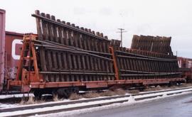
Photograph depicts ten ballast cars of the B.C. Electric Railway on newly laid industrial spur on the northeast side of the Langley depot.
Image depicts two bridges in Telkwa, B.C. One is for trains.
Photograph depicts telephone fittings on Vancouver Island.
Image depicts a set of railway tracks, and a building with a sign which reads: "Telegraphs." The location is uncertain, but possibly in the Peace River Region.
Group of men, women, and children stand in field below large sign that reads: "GRAND TRUNK PACIFIC TRACK CONNECTED APRIL 7th 1914 PRINCE RUPERT MILEAGE 373-96 - WINNIPEG MILEAGE 1,374". Two men in formal attire stand on either side of group, women and children in between. A spotted dog stands on right. It is believed that members of the Taylor family are present in group (Hermina holding infant Tom, surrounded by Violet, Lucy, Arthur, Virginia, and Dixon). Man and woman in back left speculated to be Lillian and A.K. Bourchier. Handwritten annotation on envelope of negative reads: "Ft. Fraser 1916".
Photograph depicts a tank 'Scale Test Car' at the Kamloops CPR yard.
Photograph depicts a tank that was found outside of the headquarters of the British Columbia Armoured Regiment in Vancouver.
Photograph depicts a new tank car for sodium chlorate CN/CP interchange.
Photograph depicts an old tank car owned by a logging railway on Vancouver Island, parked at the end of a spur behind a locomotive shed of the Alberni Pacific Railway.
Snow on either side of highway stands at extreme height.
Image is one of 65 photos documenting a survey of the Canada-Alaska Boundary, Taku River area, May 23 to Oct. 15, 1906.
This particular photo is one of 13 found in original enclosure with the following handwritten annotation: "SOME OTHERS." See also items 2006.20.3.22 - 2006.20.3.34.
Photograph depicts two unknown men walking on rocky shore with canoe over their heads. Water and forest in background. Handwritten annotation visible on negative: "[?] portaging canoe".
Image is one of 65 photos documenting a survey of the Canada-Alaska Boundary, Taku River area, May 23 to Oct. 15, 1906.
This particular photo is one of 8 found in original enclosure with the following handwritten annotation: "From main camp up Kopoka River. Scenes with persons in." See also items 2006.20.3.14 - 2006.20.3.21.
Photograph depicts two men paddling in canoe, shore in background. Handwritten annotation visible on negative reads: "Stughes & B_ Lake behind Main Camp Taku River".
Image is one of 65 photos documenting a survey of the Canada-Alaska Boundary, Taku River area, May 23 to Oct. 15, 1906.
This particular photo is one of 13 found in original enclosure with the following handwritten annotation: "SOME OTHERS." See also items 2006.20.3.22 - 2006.20.3.34.
Photograph depicts two men climbing up snowy area with walking poles and other gear. Handwritten annotation visible on negative: "Nellis & Gilroy Snow [?] - No.3."
Image is one of 65 photos documenting a survey of the Canada-Alaska Boundary, Taku River area, May 23 to Oct. 15, 1906.
This particular photo is one of 13 found in original enclosure with the following handwritten annotation: "SOME OTHERS." See also items 2006.20.3.22 - 2006.20.3.33.
Photograph depicts two men standing on mountain with walking sticks, carrying bundles on their backs. Valley and mountains visible in background below. Handwritten annotation visible on negative: "[?] Climbing [?] Sta - K. River" (Kopoka?).
Image is one of 65 photos documenting a survey of the Canada-Alaska Boundary, Taku River area, May 23 to Oct. 15, 1906. This particular photo is one of 7 found in original enclosure with the following handwritten annotation: "Around River Taku and main camp on same." See also items 2006.20.3.35 - 2006.20.3.41.
Photograph depicts unknown men standing with walking sticks, carrying large bundles on their backs. Water and opposite shore in background, mountains visible in distance. Handwritten annotation visible on negative: "Billy [Gilroy?] & [?] packed for [?]".
Image is one of 65 photos documenting a survey of the Canada-Alaska Boundary, Taku River area, May 23 to Oct. 15, 1906.
This particular photo is one of 13 found in original enclosure with the following handwritten annotation: "SOME OTHERS." See also items 2006.20.3.22 - 2006.20.3.34.
Photograph depicts three unknown men standing in water while pulling loaded canoe by rope. Rocky shore and hills in background. Illegible handwritten annotation visible on negative: "...[K. River]?" (Kopoka?)
Image is one of 65 photos documenting a survey of the Canada-Alaska Boundary, Taku River area, May 23 to Oct. 15, 1906.
This particular photo is one of 8 found in original enclosure with the following handwritten annotation: "From main camp up Kopoka River. Scenes with persons in." See also items 2006.20.3.14 - 2006.20.3.20.
Photograph depicts two unidentified men on small boat with sail, opposite shore in background. Handwritten annotation on negative: "Prospectors on Taku Sailing".
Image is one of 65 photos documenting a survey of the Canada-Alaska Boundary, Taku River area, May 23 to Oct. 15, 1906.
This particular photo is one of 13 found in original enclosure with the following handwritten annotation: "Kopoka River - river scenes Aug 29 to Oct. 9 [19]06". See also items 2006.20.3.1 - 2006.20.3.13.
Photograph depicts three unidentified men loading canoe on river shore.
Image is one of 65 photos documenting a survey of the Canada-Alaska Boundary, Taku River area, May 23 to Oct. 15, 1906.
This particular photo is one of 8 found in original enclosure with the following handwritten annotation: "From main camp up Kopoka River. Scenes with persons in." See also items 2006.20.3.14 - 2006.20.3.21.
Photograph depicts unknown man in canoe, opposite shore and hills in background.
Image is one of 65 photos documenting a survey of the Canada-Alaska Boundary, Taku River area, May 23 to Oct. 15, 1906.
This particular photo is one of 8 found in original enclosure with the following handwritten annotation: "From main camp up Kopoka River. Scenes with persons in." See also items 2006.20.3.14 - 2006.20.3.21.
Photograph depicts unknown man standing in water while pulling loaded canoe by rope. Rocky shore in foreground, mountains in background. Handwritten annotation visible on negative: "[?] hauling canoe. Big [?], Kopoka".
Image is one of 65 photos documenting a survey of the Canada-Alaska Boundary, Taku River area, May 23 to Oct. 15, 1906.
This particular photo is one of 8 found in original enclosure with the following handwritten annotation: "From main camp up Kopoka River. Scenes with persons in." See also items 2006.20.3.14 - 2006.20.3.21.
Mountains stand behind water in background. Handwritten annotation on negative: "looking [over?] Kopoka".
Image is one of 65 photos documenting a survey of the Canada-Alaska Boundary, Taku River area, May 23 to Oct. 15, 1906.
This particular photo is one of 13 found in original enclosure with the following handwritten annotation: "Kopoka River - river scenes Aug 29 to Oct. 9 [19]06". See also items 2006.20.3.1 - 2006.20.3.13.
Photograph depicts a switching locomotive and stand-in locomotive.
Photograph depicts switcher #8106 and caboose #434612 that just arrived with a loaded train from a pulp mill. To the left lay the main track to Nelson.
Photograph depicts switcher #8106 that served the 3 mile branch to a pulp mill. The switcher pulled with heavy string of loaded cars from the mill. The trip was a caboose run. Locomotive built in 1958 as part of a batch of 31. 17 of them remained in 1997.
Photograph depicts the swing span of the road and rail bridge at Mission City, looking upstream from the south bank.
Photograph depicts the CPR swing bridge crossing the Harrison River at Harrison Mills. It is a plate girder bridge carrying a double track. The bridge tender occupied a shanty at the east end of the bridge at mile 68.3 from North Bend. The timetable states that trains may proceed at restricted speed after stopping, if the tender fails to appear after 4 whistle signals and the hone signals show stop.
Photograph depicts a man seated on cab floor of dragline crane with " CAMPBELL CONSTRUCTION Co. LIMITED" on its side door. The crane is elevated on a man-made dirt hill (see also item 2005.3.40), with forest in background. Handwritten caption beside this photo reads: "Swamper on Shovel".
Image depicts a trailer for a logging truck suspended off the ground by a wooden structure. This is used to load the trailer onto the back of the truck. The name on the truck says "Rormarniewich Trucking Ltd."
Handwritten photo album caption below this photo reads: "The above ship, after 'doing' a barrel-roll 50 feet above the runway." Photograph depicts three men in uniform bent over wreckage of plane crash in airstrip believed to be at Whitehorse, YT. Large group of men and vehicles in background on right, trees and hillside in background on left.
Royal Canadian Air ForcePhotograph depicts the Superior Propane Ltd. tank yard behind Wilkinson Steel Ltd.
Photograph depicts a sunken whaler with a harpoon gun. A destroyer or, possibly, a corvette was being broken up in the middle background.
Photograph depicts the close up of harpoon guns of a sunken whaler in the Upper Harbour of Victoria.
Photograph depicts block ships sunk to protect booming grounds at Powell River. The ships were former wartime naval vessels.
View of Summit Lake with sun at horizon reflected in water and dark clouds above. Part of a man's head is silhouetted in the foreground. Handwritten caption above this photo reads: "Sumit Lake."
Photograph depicts a train spotted at the Summerland depot.
Photograph depicts the Sumas depot of the Northern Pacific Railway in the U.S. The Canadian border is at the grade crossing in the middle distance.
Photograph depicts a small car and passengers on log ferry in foreground and one man on dock. Stuart River and forested banks in background. Handwritten photo caption below photograph reads: "Stuart River Ferry."
Photograph depicts the Cassiar mine. North peak featured in left background, South peak in right background, and West peak in right foreground. Area to left of the mining pit and West peak was called the "cirque waste dump." Location of new mine garage can be seen just above the "#7 switchback" road in bottom right foreground.
Street scene in Prince George B.C. Several Union Jack flags are visible and there is a celebration banner at the end of the street. Long shadows in photo indicate summer (perhaps Dominion Day?). River in foreground, railroad and city in mid ground and hill in background. Printed annotation on recto reads: “Prince George. B.C.”
Image depicts a street in Giscome. The store was previously located on the left. The church is in the background. Map coordinates 54°04'18.5"N 122°21'57.7"W
Photograph depicts former street car tracks in New Westminster.
Photograph depicts a street car body that formerly belonged to Vancouver, but was found by Davies in Penticton.
Image depicts the BCR, as well as the Dunkley Lumber Mill, in Strathnaver, B.C.
Photograph depicts machinery stored in Summerland beside KVR track. Property of the KVR Historical Society.
Photograph taken at the CN Kamloops Junction on a storage line.
Image depicts Stewart Harbour in Stewart, B.C.
Wide angle view of mountains and small residential buildings. A large dock is visible in the foreground. Annotation on recto reads: "Stewart, BC., from Government Wharf."