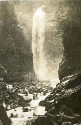
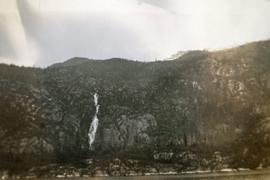
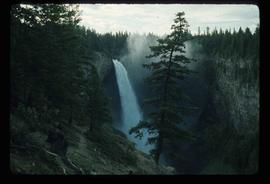
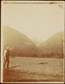
Image depicts a waterfall with a mountain peak in the background; it is most likely Mt. Robson.
Photograph depicts a waterfall and stream with rocky banks.
Photograph depicts white rapids at bottom of waterfall in Bulkley River, B.C. Fishing territory visible on far right; hill on opposite shore in background.
Photograph depicts piles of wood planks and log booms in the foreground with a waterfall in the background.
Photograph depicts a waterfall in a forested area with a riverbank in the foreground.
Photograph depicts a waterfall on a rocky mountainside, an expanse of ocean in the foreground.
Photograph depicts a waterfall on a rocky mountainside. There are snow peaked mountains in the distance.
Photograph features rapids in foreground, trees and rocks in background.
Handwritten annotation on verso reads: "A waterfall on American side of the Canal. Chapt. XXVI Waterfall on Alaskan side of Portland Inlet."
Wide angle view of Prince Rupert harbour taken from the water. Forest and mountains are visible in the background. Annotation on recto reads: "Prince Rupert BC '07."
Image depicts the Watson Mansion at Mile 108 of Highway 97. It was built by Captain Geoffrey Watson in 1904, and was burned down by a chimney fire in 1983.
Group of six men sit and stand on small boat close to shore. Rev. W.E. Collison stands on far right (son of Marion and Archdeacon W.H. Collison).
Handwritten annotation on verso reads: "Dr. Macdonald Med officer (Kincolith) / Dr. [McQuarrie?] Med officer Victoria / Steven Clayton Native boat owner / Capt. Bary - Insp. of Indian Schools / W.E. Collison Indian agent. / Inspection trip to villages of upper Nass River".
Rev. William Edwin Collison stands waist deep in water, with axe resting on shoulder (oldest son of Archdeacon W.H. Collison). Trees and hill on opposite shore visible in background.
Handwritten annotation on verso reads: "Dad at Kincolith".
Three men can be seen on deck of small boat. Rocky shore in foreground, forest and hills on opposite shore in background.
Handwritten annotations on verso read: "Dad - en route up Nass River on official business. (hence the flag & business suit!)"; "Going up the Nass. Dad (Indian Agent) Cap Barry (Inspect. of Schools) travelling up the Nass River to Aiyansh".
Image depicts Wells, B.C.
Image depicts the Helmcken Falls in Wells Gray Provincial Park.
Image depicts the drainage area for the Helmcken Falls in Wells Gray Provincial Park.
Photograph depicts the old hospital building in Wells. At the time the photo was taken, 1978, it was being used as an apartment building, and that is still its current use.
Image depicts woods located west of Leo Creek, with mountains in the distance.
Photograph depicts a westward view from the terminal building at the Rainbow Lake Ski Club.
W.H. Collison stands on a rocky river bed pointing to a pass in between distant mountains.
Handwritten annotation in pen on verso reads: “A rift in the mountains for Chapt. XXI. No.4”
Archdeacon William Henry Collison stands with cane in centre of group, trees and hills in background.
Handwritten annotation on verso reads: "Meadow - Kincolith / Uncle Don - Grandfather, Aunt Alice, Aunt Elsie / Uncle Max + cousins". Donald Macdonald married W.H. Collison's daughter Emily.
Photograph depicts a jut of treed land in the Kettle river.
Image depicts a grave somewhere along the White Pass railway.
Image depicts a mountain side somewhere along the White Pass railway. The thin ridge along the mountain side is possibly either a highway or part of the railway.
Image depicts the White Pass Train crossing over a railway bridge at an uncertain location.
Image depicts the White Pass Train crossing over a railway bridge at an uncertain location in the mountains.
Image depicts the White Pass Train crossing over a railway bridge at an uncertain location.
Trees in foreground, hills in background. Unidentified man stands on far left.
Photograph is one of 11 images taken during a World Health Organization (WHO) trip, Human Rights of Women and Children, Peru, 1990. Possibly affiliated with World Council of Churches, International Ecumenical Delegation to Lima, Peru, 14-25 October 1990. See also items 2009.6.1.505 - 2009.6.1.515.
Rock pile, unknown building, and hills can be seen in background.
Photograph is one of 11 images taken during a World Health Organization (WHO) trip, Human Rights of Women and Children, Peru, 1990. Possibly affiliated with World Council of Churches, International Ecumenical Delegation to Lima, Peru, 14-25 October 1990. See also items 2009.6.1.505 - 2009.6.1.515.
Photograph depicts Wickaninnish Beach, north of Ucluelet on Vancouver Island.
Image depicts an aerial view of Williams Lake, B.C.
Image depicts a view of Williams Lake, B.C.
Image depicts an aerial view of Williams Lake, B.C.
Image depicts the St. Joseph's Mission in Williams Lake, B.C.
Image depicts the cableway in Willow River, B.C.
Image depicts the cableway, stretching over a river, in Willow River, B.C.
Image depicts the cableway in Willow River, B.C.
Image depicts a group of people somewhere in Willow River, B.C. The man in the plaid shirt and beige cap is identified on the slide as being Lloyd Edwards.
Image depicts a playground in Willow River, B.C. The slide labels it as being a "former hotel site." Map coordinates 54°04'23.7"N 122°28'26.9"W
Image depicts the Willow River General Store. Map coordinates 54°04'23.7"N 122°28'26.9"W
Image depicts a snowy street in Willow River, B.C. with a row of houses. The white building on the end with the Pepsi sign is the Willow River General Store. Map coordinates 54°04'18.3"N 122°28'14.7"W