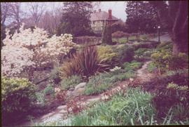
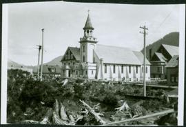
Image depicts a number of townhouses in Chetwynd, B.C.
Image depicts a view of a saw mill in Chetwynd, B.C.
Image depicts several businesses in a small section of Chetwynd, B.C. There is a motor hotel and a half-visible sign for an Esso gas station.
Image depicts several houses in Chetwynd, B.C.
Image depicts a Chevron station as well as two motels in Chetwynd, B.C.
Image depicts a view of Chetwynd, possibly from Highway 97.
Interior photograph of a church. Printed annotation on recto reads: “Chapel, Indian school, Fraser Lake B.C.”
Photograph depicts four men standing near fully packed horse-drawn cart in front of wood buildings, including a long building with a porch and chairs. Trees on hill visible in background. Handwritten annotation on recto of photograph: "Changing teams on the Cariboo Road".
Chancellor Campagnolo stands with five unidentified Quick Start students, Fred Gilbert, and Nick Petraryszak. Photograph was taken during the chancellor's tour of the Peace-Liard Region, 1993.
Group features Charles Jago, Mike Hammar, Jacob McKay, Bert McKay, Deborah Poff, Alex Michalos, Dennis Macknak, Margaret Anderson, David Fish, Dean Doug Nord, and Fred Beil. Photograph was taken during the chancellor's tour of Nass Valley, ca. 1992.
Group features Charles Jago, Mike Hammar, Jacob McKay, Bert McKay, Deborah Poff, Alex Michalos, Dennis Macknak, Margaret Anderson, David Fish, Dean Doug Nord, Fred Beil, and Chancellor Iona Campagnolo. Photograph was taken during the chancellor's tour of Nass Valley, ca. 1992.
Left to right: Charles Jago and unidentified woman, David Fish, Dennis Macknak, Deborah Poff, unidentified woman and child, Iona Campagnolo, Lee Morrison, Ellen Facey, two unidentified women. Teepees visible in background. Photograph was taken during the chancellor's tour of Xats'ull Heritage Village, Soda Creek First Nation, Williams Lake, B.C.
Chancellor Campagnolo stands with man believed to be the mayor of Tumbler Ridge, President Geoffrey Weller, and Dean Fred Gilbert. Photograph was taken during the chancellor's tour of the Peace-Liard Region, 1993.
Chancellor Campagnolo stands with Chetwynd Mayor Charlie Lasser, President Geoffrey Weller, an unidentified man, and Fred Gilbert. Photograph was taken during the chancellor's tour of the Peace-Liard Region, 1993.
Handwritten annotation on verso reads: "chetwynd".
Two unidentified woman are also visible with the group, on far left and in centre with arm raised. Young girl sits on post in foreground. Photograph was taken during the chancellor's tour of Xats'ull Heritage Village, Soda Creek First Nation, Williams Lake, B.C.
Unidentified women stands in centre background with arm raised, and a young girl sits on post in foreground. Photograph was taken during the chancellor's tour of Xats'ull Heritage Village, Soda Creek First Nation, Williams Lake, B.C.
Handwritten annotation on verso reads: "UNBC 1992".
Unidentified women stands in centre background with arm raised, and a young girl sits on post in foreground. Photograph was taken during the chancellor's tour of Xats'ull Heritage Village, Soda Creek First Nation, Williams Lake, B.C.
Unidentified woman stands third from right, with arm raised. Photograph was taken during the chancellor's tour of Xats'ull Heritage Village, Soda Creek First Nation, Williams Lake, B.C.
View from above; unidentified woman also visible with the group. Photograph taken during the chancellor's tour of Xats'ull Heritage Village, Soda Creek First Nation, Williams Lake, B.C.
Image depicts a snowman drawn on the chalkboard of what appears to be an unused school, possibly in Lamming Mills, B.C. The slide is labelled "note board school."
Photograph of a Canadian Grain elevator next to the railway in Prince Rupert, BC. Printed annotation on recto reads: "C.G. Elevator. Prince Rupert."
Street scene depicts people, boardwalks, tents, and store front. Printed annotation on recto reads: “Centre St. Prince Rupert: B.C., Allen Photos May 17. 09” Handwritten message on verso is addressed to “Dearest Darr”
Street view of a crowd of men milling around on Centre Street in Prince Rupert, BC. Printed annotation on recto reads: "Centre Street, Prince Rupert, B.C."
Street view of Centre Street in Prince Rupert, BC. Buildings are in various states of construction. Printed annotation on recto reads: "Centre St Prince Rupert B.C. June 20/08 JDA.""
Photograph of residents in motion on Centre Street in Prince Rupert. Buildings are visible on either side of the street and a railway track runs down the length of the road. Annotation on recto reads: "Centre Street, Prince Rupert, BC. 1664."
Elevated street view of a large crowd gathered on Centre Street in Prince Rupert for Dominion Day celebrations. The Dominion Day arch is visible in the background. Printed annotation on recto reads: "Centre Street, Prince Rupert, B.C. Dominion Day Celebration."
Photograph of Centre Street in Prince Rupert on Dominion Day. The Union Bank of Canada is located on the left side of the street, and a decorative arch can be seen in the background. Annotation on recto reads: "Centre Sr. Prince Rupert Dominion Day Celebrations 1909 Allen Photo July 09."
Photograph depicts crowds of people walking through street, hills in background. Printed annotation on recto reads: “Centre St. Prince Rupert May Celebrations 1909, Allen Photo July 09.” Handwritten annotation in ink on recto reads: “Prince Rupert 1909”
Image depicts Central Street West, parallel to Highway 97 in Prince George, B.C. looking north. Shown: Prince George Motors and other car dealerships, Burger King, Grama's Inn, and the Spruceland Shopping Mall sign. Map coordinates 53°54'42.1"N 122°46'53.1"W
Street view of the Dominion Building in Prince Rupert, which contains the Government telegraph Office and Post Office. Printed annotation on recto reads: "Central Post Office Prince Rupert B.C." Handwritten annotation on verso reads: "Aug 18th. The cor. of the High bldg. on the right is the Prince Rupert Hotel. Front side is other way 5 stories high at [illegible] Hotel is in the next block. Notice [??] at the back is al-the [sic] lots of Hill leading down to Shops [??]. St. James' Hotel close by Prince Rupert was 5 stories high. For sure had [??] chimneys on it- a big fire engulfed [??] it about a year ago and it is being taken down. I must go & work bye bye. Love Dady. Psalm 46-1 & 48-14 was my AM verses specially."
Image depicts an old, boarded up school, possibly the Central Fort George Traditional School in Prince George, B.C.
Photograph depicts landscape with cleared land in foreground, river in middle, building and trees in background.
Handwritten annotation on verso: "Central Fort George 1911".
Image depicts the Central Business District of Prince George looking north from Connaught Hill. Map coordinates 53°54'41.4"N 122°44'58.5"W
Image depicts 3rd Ave at Victoria St. Map coordinates 53°55'03.9"N 122°44'54.8"W
Printed annotation on recto reads: “Central Avenue Fort George B.C. Copyright Canada June 25th 1913”. Handwritten annotation in ink on recto reads: “Hotel Fort George; Pool room; Men’s furnishing; General store; Bank Vancouver; Telephone office; Temperance House; Trust-company; Grand stand & fair grounds; Hospital; Ware house and general store.” Cancelled 1 cent Canadian stamp on verso is dated: "Fort George BC Jul 14 13". Handwritten message in ink on verso is addressed to Mr. Chas H Wilson 94 Gould St Toronto: "Fort George. B.C> Box 65, July 13/ 13. Dear Father, This is a 'bird's eye view' of our main street - ha! ha! some class alright. We live right behind the bakery lunch room on the right hand side of the picture, on 1st avenue, some people eh? Will be moving to Cassiar Ave soon. How are all the folks. Mae is writing. Peace. M."
Image depicts the interior of the Centennial Hall in Wells, B.C.
Image depicts the Centennial Hall in Wells, B.C.
Image depicts a bridge over Cayoosh Creek.
Photograph depicts a cattle shelter/ barn at the head of Nicola Lake, 20 miles east of Merritt, near the Douglas Lake road turnoff.
Photograph depicts a cattle shed located 3 miles east of Pavilion Lake, which is 15 miles northeast of Lillooet. It may have been a settler's cabin at one time.
Photograph depicts a cattle barn of the Douglas Lake Ranch.
Photograph depicts Catholic church, with rectory on its left, and First United Church behind. A wood boardwalk crosses midground, and a man can be seen riding a bicycle near church. Power lines and rough cleared land in foreground, hills and mountains in background. Handwritten annotation on recto of photograph: "Church in Rupert."
Image depicts the Catholic Church in Penny, B.C.
Photograph depicts the catholic church at Cobble Hill on Shawnigan Lake.