Mostrando 3218 resultados

Archival description
3218 resultados con objetos digitales Muestra los resultados con objetos digitales
Upper Fraser Road in Upper Fraser, BC
2012.13.1.87.041 · Item · [between 1975 and 1995]
Parte de J. Kent Sedgwick fonds

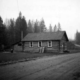
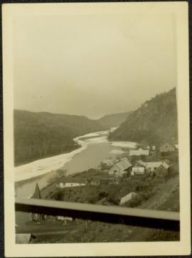
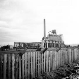
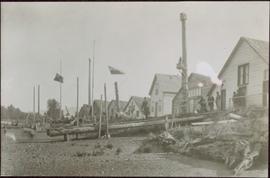
Image depicts the Upper Fraser Road running through Upper Fraser, B.C. A beehive burner is seen in the background on the left and the mill office is seen on the right. Map coordinates 54°07'05.7"N 121°56'38.9"W

Upper Fraser Residences
2012.13.1.87.047 · Item · [between 1975 and 1995]
Parte de J. Kent Sedgwick fonds

Image depicts an older building with numerous vehicles parked out front in Upper Fraser, B.C. Map coordinates 54°07'03.5"N 121°56'34.4"W

Upper Fraser Mill
2012.13.1.87.044 · Item · [between 1975 and 1995]
Parte de J. Kent Sedgwick fonds

Image depicts entrance to mill yard for Upper Fraser mill in Upper Fraser, B.C. Map coordinates 54°07'10.8"N 121°56'51.7"W

Upper Fraser Mill
2012.13.1.87.046 · Item · [between 1975 and 1995]
Parte de J. Kent Sedgwick fonds

Image depicts Upper Fraser mill yard with log deck and beehive burner in silhouette across railroad tracks. Located in Upper Fraser, B.C. Map coordinates 54°07'01.5"N 121°56'29.6"W

Upper Fraser Mill
2012.13.1.87.064 · Item · [between 1975 and 1995]
Parte de J. Kent Sedgwick fonds

Image depicts numerous log decks at the Upper Fraser sawmill. Map coordinates 54°07'10.8"N 121°56'51.7"W

Upper Fraser Mill
2012.13.1.87.062 · Item · [between 1975 and 1995]
Parte de J. Kent Sedgwick fonds

Image depicts the entrance to the Upper Fraser mill yard in Upper Fraser, B.C. Map coordinates 54°07'10.8"N 121°56'51.7"W

Upper Fraser Mill
2012.13.1.87.063 · Item · [between 1975 and 1995]
Parte de J. Kent Sedgwick fonds

Image depicts the Upper Fraser mill yard with a CN train in Upper Fraser, B.C. Map coordinates 54°07'10.8"N 121°56'51.7"W

Upper Fraser Mill
2012.13.1.87.061 · Item · [between 1975 and 1995]
Parte de J. Kent Sedgwick fonds

Image depicts the entrance to the Upper Fraser mill yard in Upper Fraser, B.C. Map coordinates 54°07'10.8"N 121°56'51.7"W

Upper Fraser Mill
2012.13.1.87.066 · Item · [between 1975 and 1995]
Parte de J. Kent Sedgwick fonds

Image depicts the Upper Fraser Road running through Upper Fraser, B.C. A newer style round burner is seen in the background. Map coordinates 54°07'05.7"N 121°56'38.9"W

Upper Fraser General Store
2012.13.1.87.043 · Item · [between 1975 and 1995]
Parte de J. Kent Sedgwick fonds

Image depicts the Upper Fraser General Store in Upper Fraser, B.C. Two other signs indicate that it is also a post office and a place that offers propane refills. Map coordinates 54°07'10.8"N 121°56'51.7"W

Unknown Family by House
2009.5.2.22 · Item · [ca. 1900]
Parte de Taylor-Baxter Family Photograph Collection

Photograph depicts a man and woman standing beside an elderly woman on grass lawn. Wood boardwalk runs beside house, steps and porch featured on left. A jack russell terrier stands at their feet. Neighbouring yards in background.

Unknown Family by House
2009.5.2.25 · Item · [ca. 1900]
Parte de Taylor-Baxter Family Photograph Collection

Photograph depicts a man and woman standing beside an elderly woman on wood boardwalk near front porch. Window plants hang beside them and a jack russell terrier sits at their feet. Neighbouring yards in background.

Unknown Family by House
2009.5.2.23 · Item · [ca. 1900]
Parte de Taylor-Baxter Family Photograph Collection

Photograph depicts a man and woman standing beside an elderly woman on boardwalk running alongside house. Window plants in foreground, neighbouring yards in background. A jack russell terrier stands in left foreground.

Union Bay post office
2013.6.36.1.073.04 · Item · [July 1982]
Parte de David Davies Railway Collection

Photograph depicts the post office in Union Bay. It was a "Heritage" building and internally restored. Believed to have been built in 1908.

Unidentified Man at Log Cabin
2009.5.1.50 · Item · [ca. 1910]
Parte de Taylor-Baxter Family Photograph Collection

Photograph depicts a man seated with bundles and briefcase in front of two small log cabins with sod roofs. What appears to be an elevated log cache stands to left behind cabins, with a ladder raised to its door. Rocky, dry field crosses foreground, mountains visible in background.

Unidentified First Nations village
2009.7.1.163 · Item · [ca. 1910]
Parte de Archdeacon W. H. Collison fonds

Shoreline perspective of an unidentified coastal village situated on B.C.’s north coast. European style houses run parallel to a rocky shore. Seven men and one child stand within this frame and totem poles and a mortuary pole are also visible along the shoreline.

2009.7.1.255 · Item · 13 August 1908
Parte de Archdeacon W. H. Collison fonds

Photograph of a half-demolished building attached to a large dock. A large group is milling around the damage. Debris litters the water. Annotation on recto reads: "Undesired result of big blast at Prince Rupert. August 13 1908. Allen Photo."

Undershot water wheel
2013.6.36.1.079.11 · Item · 5 Sept. 1970
Parte de David Davies Railway Collection

Photograph depicts the same person who owned the service station building electric generator house in Trout Lake. He also built an undershot water wheel that was driven by Lardeau Creek.