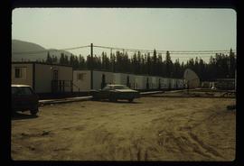
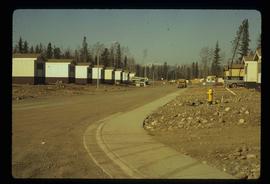
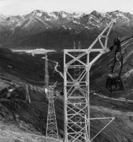
Photograph depicts the town of Cassiar, mountain base in background. Mine road visible in top right of image.
Photograph depicts the Cassiar valley: town on left, plant on right, mine valley in background. Photograph was taken from above, facing north east.
Photograph depicts the town of Cassiar behind plant and tailings pile in foreground. Mountain range in background.
Photograph depicts the town of Cassiar, mountain base in background.
Photograph depicts the town of Cassiar in foreground, mountain base in background. Photograph was taken from the air, portion of plane visible in top left of image.
Photograph depicts the Cassiar townsite in foreground. Mill, dry rock storage building, and tailings pile can be seen in background. Handwritten annotation on verso of photograph: "1958 [1961 crossed through]."
Photograph depicts the Cassiar plantsite including the mill, dry rock storage building, tailings pile, and many other buildings. A portion of the townsite can be seen on left.
Photograph depicts the Cassiar plantsite in foreground, including the mill, dry rock storage building, tailings pile, and many other buildings. Townsite in midground, mountains in background. Handwritten annotation on recto of photograph: "Cassiar."
Photograph depicts the Cassiar valley. Handwritten annotation on verso of photograph: "1958 [1961 crossed through]", on recto: "Cassiar Asbestos Corporation Limited. Cassiar B.C. Townsite in foreground mill and ore storage in left middle ground," "Toronto set". It is believed that this photograph was made into a post card.
Photograph depicts a track shed about 1 mile south of Beaverdell or at about mile 43.25 on the CPR line in the Carmi Subdivision. Despite the open doors and ease of access, it was the only hut on the line found to contain track materials and correspondence. It retained 50 memos addressed to the Section Foreman [at Beaverdell?].
Photograph depicts the track transfer transporter at the Canadian National Railway (CN) repair shops at Port Mann.
Photograph depicts the track transfer transporter at the Canadian National Railway (CN) repair shops at Port Mann, showing the east face of the main building.
Photograph depicts man standing in front of log building with the sign "RCMP" above center window. Moose antlers mounted on roof. Forest visible in background on right.
File contains slides depicting a trail, and other areas, near Rossland, B.C.
Image depicts a patch of snow-covered ground with a sign that reads "Trail of 98," somewhere along the White Pass railway.
Image depicts Upper Fraser residential area during demolition of town site. Map coordinates 54°06'51.6"N 121°56'26.3"W
Image depicts a number of trailer homes in Tumbler Ridge, B.C.
Image depicts trailer homes in Prince George, B.C.
Image depicts a number of trailer homes in Tumbler Ridge, B.C.
Image depicts a trailer park by either the Fraser or Nechako River in Prince George, B.C.
File contains 20 slides date stamped between July and August 1976 and annotated “TRAILER SERVICE SUMMER 1976", depicting the construction and renovation of a mobile home, excavations, and structures believed to be wells or water boxes. File also contains 9 additional slides with no annotations, depicting mobile home and houses in winter. These 9 images are associated with materials dated Nov. – Dec. 1976 and it is likely that these photographs were taken in the winter of 1975-1976.
Image depicts mobile homes for sale on Cowart Road looking northeast with Simon Fraser Bridge in background. Map coordinates 53°52'39.3"N 122°46'13.1"W
Image depicts a train in an uncertain location, though it is possibly Howe Sound in the background.
Image depicts a train in an uncertain location.
The photograph depicts train engine maintenance equipment in the interior of the roundhouse at the CN Railyard in Prince George, B.C. Reproduction of photograph from 1984.
Image depicts what is possibly a train fuelling station at the GTP Roundhouse in Prince George, B.C.
Image depicts what is possibly a train fueling station at the GTP Roundhouse in Prince George, B.C.
Image depicts a train in the interior of the GTP roundhouse in Prince George, B.C.
Image depicts a train in the GTP roundhouse in Prince George, B.C.
Image depicts a train on the Hansard Bridge across the Fraser River looking west. Map coordinates 54°04'37.7"N 121°50'39.9"W
Image depicts a train and several unidentified individuals who appear to be waiting for it as it passes through Sinclair Mills, BC.
Photograph depicts the junction station of the Esquimalt and Nanaimo Railway at Parksville on Vancouver Island. The view is looking south.
The photograph depicts the old train station in Prince George. The door reads CN. Photograph likely reproduction from 1984.
Image depicts a train track and several buildings in an unknown location.
Photograph of a train traveling through Prince Rupert. Several people are gathered on the dock and around various buildings. Two small vessels are docked in the harbour. Annotation on recto reads: "Prince Rupert, Waterfront. Allen Photo May '4."
Image depicts a train carrying logs somewhere in Prince George, B.c.
Image depicts a train and a group of unknown individuals at the GTP roundhouse in Prince George, B.C.
Image depicts several trains at the Giscome mill site in Giscome, B.C. Map coordinates 54°04'19.7"N 122°22'04.7"W
Image depicts trains at the Grand Trunk Pacific railway roundhouse in Prince George, B.C.
File contains photographs featuring the tramline at Cassiar which ran from the crushing plant at the mountain mine to the plantsite in the valley (a drop of 427 meters). The first ore was originally transported by truck to the plant until the gravity chute was built in 1953. This chute was replaced with the first aerial tramline model in 1956, which was succeeded by the second model in 1975. This file also includes one photo of the original gravity chute, and one photo depicting a tramline worker.
Additionally there is a collection of eighteen photographs of tramline cars that were being surveyed for damage and condition, and another collection of six photographs of tramline study. The results of this study determined that there was variances in load sizes of the buckets caused by extra material falling off the panfeeder.
Photograph depicts towers and buckets in distance. Gravel road in foreground winding through hills of dirt. Handwritten annotation on recto of photograph: "#1 SECTION". Photograph was glued to cardboard backing with the annotation: "1962".
Photograph depicts towers and bucket in foreground, plantsite midground in valley, opposite mountains in background. Handwritten annotation on recto of photograph: "GENERAL VIEW VISIBLE TOWERS ARE IN #1 SECTION PLANT IN BACKGROUND". Photograph was glued to cardboard backing with the annotation: "1962".
Photograph depicts the Transformer Sub-Station of West Kootenay Power and Light Company, which is the only private power distribution company left in B.C. at the time. In was built in 1905 and was in operation by 1906. There were identical buildings made in Grand Forks and Phoenix, but they were demolished at the latter place.
Photograph depicts a trappeers cabin on the northend of Trout Lake and Trout Lake City. It was maintained in good condition by present owners who valued its age.
Image depicts two unidentified individuals examining a thick log still attached to the machine that cut it down. It is located somewhere in Prince George, B.C.
Image depicts two old houses surrounded by numerous trees at an uncertain location.
Image depicts a stand of trees and a shed at Island Cache.
Photograph depicts Trelle Morrow and Jim Rankin at the Soda Creek cemetery. Annotation on verso: "Trelle M. and Jim Rankin at Soda Creek cemetery, 2010."