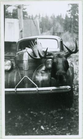
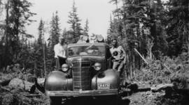
Imprimir vista previa Cerrar

Mostrando 975 resultados

Archival description
975 resultados con objetos digitales Muestra los resultados con objetos digitales
Namu Cannery
2004.2.1.69 · Item · [between 1898 and 1910]
Parte de Reverend R.W. Large fonds

Photograph depicts a cannery on pilings with a body of water in the foreground with a forested area in the background.

Namu Cannery
2004.2.1.83 · Item · 1898-1920
Parte de Reverend R.W. Large fonds

Photograph depicts a cannery on wood pilings with several other buildings along a forested shoreline with a body of water and boat in the foreground.

Moyie Lake, BC
2013.6.36.1.005.11 · Item · Oct. 1965
Parte de David Davies Railway Collection

Photograph depicts Moyie Lake, 15 miles south of Cranbrook, and Moyie Station. The tailings are from a lead and zinc mine directly to the right of the photograph on the hillside. The view is looking north.

Moving mountains in Prince Rupert, BC
2011.3.3.86 · Item · 17 July 1913
Parte de North Coast & Central BC Postcard Collection

Photograph of a large explosion on a rocky shoreline. A bridge is visible in the foreground and a body of water is partially visible in the background. Printed annotation on recto reads: "McRae Bros Moving Mountains at Prince Rupert BC Apr 24th" Handwritten annotation on verso reads: "Rupert. July 17 1913. Dear [illegible]. Just a card for that album if you've got any room left by now. This is one of the blasts for the clearing of the drydock up here. [Illegible] W.M." Postcard is addressed to: "Miss C.M. Ranip[??] 931 Northlane Av.[sic] Seattle Wash." Two Canadian one cent stamps are affixed on verso. Postmark reads: "Prince Rupert BC. PM Jul 17 13."

Moving mountains at Prince Rupert BC
2009.7.1.265 · Item · 24 April 1913
Parte de Archdeacon W. H. Collison fonds

Photograph of a large explosion on a rocky shoreline. A bridge is visible in the foreground and a body of water is partially visible in the background. Annotation on recto reads: "McRae Bros Moving Mountains at Prince Rupert BC Apr 24th"

Mother Bear and Cubs in Forest
2005.3.51 · Item · [ca. 1945]
Parte de John Hart Highway Photograph Collection
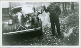
Handwritten caption below this photo reads: "Bought in Picture Prince George". Photograph depicts a mother grizzly bear standing on her hind legs against tree, so that her facial profile is visible. Two cubs stand on hind legs facing and leaning against her.

Mosquito Creek Gold Mining
2012.13.1.37.05 · Item · 1974
Parte de J. Kent Sedgwick fonds

Image depicts several unknown individuals present as a piece of machinery is used to assist in the mining of gold at Mosquito Creek in Wells, B.C.

2008.3.1.22.23 · Item · [ca. 1995]
Parte de Bridget Moran fonds

Photograph depicts Moran seated to right of woman on bench in foreground. Waterfall area at Moricetown Canyon can be seen below, behind booth labeled "MONITER BOOTH". Highway and houses visible on opposite shore in background.

Model for New Mill Displayed Outdoors
2000.1.1.2.04.02 · Item · [ca. 1970]
Parte de Cassiar Asbestos Corporation Ltd. fonds

Photograph depicts large square model of the new mill building that was built at the Cassiar plant site in 1970. Model is displayed outdoors on a platform that stands on four saw horses. Machinery modeled inside the structure is colour-coded. Plant buildings and mountains in background.

Model for New Mill Displayed in Room
2000.1.1.2.04.01 · Item · [ca. 1970]
Parte de Cassiar Asbestos Corporation Ltd. fonds

Photograph depicts large square model of the new mill building that was built at the Cassiar plant site in 1970. Model is displayed on green material laid on floor against wall in unidentified room. Machinery modeled inside the structure is colour-coded.

Mining at Otter Creek, BC
2009.5.2.69 · Item · 6 June 1937
Parte de Taylor-Baxter Family Photograph Collection

Photograph depicts lumber piles and what appears to be a very long sluicing trough along Otter Creek. Forest and hills in background. Handwritten annotation on verso of photograph: "Otter Creek 6/6/37". See also item 2009.5.2.70.

Mine Valley, Plant & Town, 1961
2000.1.1.3.13.09 · Item · 1961
Parte de Cassiar Asbestos Corporation Ltd. fonds

Photograph depicts view of mine road in valley, from mountain above. Plant, tailings pile, and town visible in distance. South mountains in background. Handwritten annotation on verso of photograph: "1961", on recto: Townsite and Plantsite from mine."

Mine Valley, 1954
2000.1.1.3.13.06 · Item · 1954
Parte de Cassiar Asbestos Corporation Ltd. fonds

Photograph depicts the mine road in valley below bulldozer parked on edge of mountain. Cassiar plant and town visible in distance, south mountains behind them in background. Photo also depicts what appears to be a cloud rising from the tailings pile in plantsite.

Mine near Moyie, BC
2013.6.36.1.005.10 · Item · Oct. 1965
Parte de David Davies Railway Collection

Photograph depicts a mine 200 yards south of Moyie village, which is 20 miles south of Cranbrook. It produced silver, zinc, and lead from 1900-1910 and had a smelter a quarter mile away. The shaft was 900 ft. deep, with levels going under Moyie Lake. The head gear dates from 1925-1935 and has electric winding.

Mine Garage & West Peak
2000.1.1.3.15.09 · Item · [ca. 1958]
Parte de Cassiar Asbestos Corporation Ltd. fonds

Photograph depicts buildings near West Peak of Cassiar mine. Haul trucks parked near old mine garage in background, new mine garage and unknown buildings in foreground. Mine valley crosses midground, expansive western mountain range in background.

Mine car at Moyie Mine
2013.6.36.1.005.12 · Item · Oct. 1965
Parte de David Davies Railway Collection

Photograph depicts a mine car at Moyie mine, at Moyie, 20 miles south of Cranbrook. The mine produced silver, zinc, and lead, and worked principally from 1900-1910. It is now disused.

Mine buildings of mine at Coal Creek
2013.6.36.1.005.36 · Item · Oct. 1965
Parte de David Davies Railway Collection

Photograph depicts the mine buildings of the mine at Coal Creek that closed in 1959. The newer buildings date to circa 1930. Much of the standard gauge trackage of Morrissey, Fernie, and Michel railway (subsidiary of the Great Northern Railway) in mine area remains. The track between Coal Creek and Fernie has not been lifted.

Mine & Crusher Plant
2000.1.1.3.13.24 · Item · [ca. 1973]
Parte de Cassiar Asbestos Corporation Ltd. fonds

Photograph depicts the Cassiar mine. North and South peak featured in background, and West peak in left foreground. Pit is being developed between South peak and West peak. Old mine garage is visible in lower centre of image, and crushing plant in right foreground. Mountain range in distance.

Mill Modification 1970
2000.1.1.3.18.084 · Item · 1970 - 1978
Parte de Cassiar Asbestos Corporation Ltd. fonds

Photograph of the Mill Modification program in 1970. This photo is part of larger collection of 71 photographs of regarding the improvements to the mill as part of the plantsite and was compiled into a report in 1978.

Mill Modification 1970
2000.1.1.3.18.040 · Item · 1970 - 1978
Parte de Cassiar Asbestos Corporation Ltd. fonds

Photograph of two workers in background working on the Mill Modification program in 1970. This photo is part of larger collection of 71 photographs of this program, compiled into a report in 1978.

Men & Air Track Drill
2000.1.1.3.15.03 · Item · September 1954
Parte de Cassiar Asbestos Corporation Ltd. fonds

Photograph depicts two men working with air track drill in mine area. Hose and dynamite box in foreground, mountains in background. Handwritten annotation on verso of photograph: "Sept. 1954." This photograph was originally stored inside duotang labeled "CASSIAR ASBESTOS CORPORATION LIMITED PHOTOGRAPHS 1954"; photo caption beneath this image: "Starting New Bench at South end of Deposit."