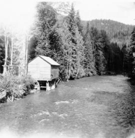
Aperçu avant impression Fermer

Affichage de 3218 résultats

Archival description
3218 résultats avec objets numériques Afficher les résultats avec des objets numériques
Water wheel on Lordeau Creek River
2013.6.36.1.079.05 · Pièce · [9 Sept. 1970]
Fait partie de David Davies Railway Collection

Photograph depicts a working undershot water wheel on Lardeau Creek River. It was the only water wheel seen in B.C. between 1963 and 1970. It was designed to drive an electricity generating set, but it was not coupelled to the set at the time.

Watson Mansion - 108 Mile Roadhouse
2012.13.1.50.015 · Pièce · 1974
Fait partie de J. Kent Sedgwick fonds

Image depicts the Watson Mansion at Mile 108 of Highway 97. It was built by Captain Geoffrey Watson in 1904, and was burned down by a chimney fire in 1983.

W.E. Collison on the Dawn
2009.7.1.285 · Pièce · [ca. 1880-1920]
Fait partie de Archdeacon W. H. Collison fonds

Archdeacon W.H. Collison and an unidentified man on the "Dawn," Collison's boat. Forested hills and several buildings are visible in the background. Handwritten annotation on verso reads: "The 'Dawn' Archdeacon Collison's boat."

2009.7.1.027 · Pièce · [ca. 1915]
Fait partie de Archdeacon W. H. Collison fonds

Group stands and sits on front steps of rectory. Left to right: Rev. William Edwin Collison, Mabel and John Maxwell Collison, Alice Collison. (William, Max, and Alice are sons and daughter of Archdeacon W.H. Collison).

Handwritten annotation on verso reads: "Dad & Auntie Al with Aunt May & Uncle Max at the rectory St. Luke's church [...?]".

Wells Hospital building
2012.13.1.37.23 · Pièce · 1978
Fait partie de J. Kent Sedgwick fonds

Photograph depicts the old hospital building in Wells. At the time the photo was taken, 1978, it was being used as an apartment building, and that is still its current use.

Wells Hotel
2012.13.1.37.46 · Pièce · [197-?]
Fait partie de J. Kent Sedgwick fonds

Image depicts a crowd of people outside the Wells Hotel in Wells, B.C.

West Summerland CPR station
2013.6.36.1.022.14 · Pièce · 2 Sept. 1970
Fait partie de David Davies Railway Collection

Photograph depicts the West Summerland CPR station in the Okanagan. The station often was used but not permanently manned. It was located at mile 9.5 from Penticton. The view is looking south.

Westbridge CPR depot
2013.6.36.1.027.14 · Pièce · [July 1966]
Fait partie de David Davies Railway Collection

Photograph depicts the Westbridge CPR depot on the Kettle Valley Line. It is located about 11 miles north of Rock Creek and at about mile 123.3 east of Penticton. The depot house is disused and the sidings contained no cars, so there appears to be no local traffic.

Wharf at Lang Bay, B.C.
2013.6.36.1.002.122 · Pièce · Apr. 1966
Fait partie de David Davies Railway Collection

Photograph depicts a wharf at Lang Bay, 14 miles southeast of Powell River. In fair repair, now used only by an oil company to pump in oil to a storage depot behind the camera.

Wharf construction
2009.7.1.162 · Pièce · [ca. 1910]
Fait partie de Archdeacon W. H. Collison fonds

Warf construction visible in foreground. Background consists of a few built structures and several tents, location unidentified.

2009.6.1.506 · Pièce · 1990
Fait partie de The Honourable Iona Campagnolo fonds

Unidentified individuals can be seen walking and sitting behind arches. One man lies on street in foreground.

Photograph is one of 11 images taken during a World Health Organization (WHO) trip, Human Rights of Women and Children, Peru, 1990. Possibly affiliated with World Council of Churches, International Ecumenical Delegation to Lima, Peru, 14-25 October 1990. See also items 2009.6.1.505 - 2009.6.1.515.

2009.6.1.511 · Pièce · 1990
Fait partie de The Honourable Iona Campagnolo fonds

Trees in foreground, hills in background. Unidentified man stands on far left.

Photograph is one of 11 images taken during a World Health Organization (WHO) trip, Human Rights of Women and Children, Peru, 1990. Possibly affiliated with World Council of Churches, International Ecumenical Delegation to Lima, Peru, 14-25 October 1990. See also items 2009.6.1.505 - 2009.6.1.515.

2009.6.1.507 · Pièce · 1990
Fait partie de The Honourable Iona Campagnolo fonds

The group stands in front of a brick wall.

Photograph is one of 11 images taken during a World Health Organization (WHO) trip, Human Rights of Women and Children, Peru, 1990. Possibly affiliated with World Council of Churches, International Ecumenical Delegation to Lima, Peru, 14-25 October 1990. See also items 2009.6.1.505 - 2009.6.1.515.

2009.6.1.508 · Pièce · 1990
Fait partie de The Honourable Iona Campagnolo fonds

The group stands in front of a cement building.

Photograph is one of 11 images taken during a World Health Organization (WHO) trip, Human Rights of Women and Children, Peru, 1990. Possibly affiliated with World Council of Churches, International Ecumenical Delegation to Lima, Peru, 14-25 October 1990. See also items 2009.6.1.505 - 2009.6.1.515.

2009.6.1.513 · Pièce · 1990
Fait partie de The Honourable Iona Campagnolo fonds

Vehicles and large cement building in background.

Photograph is one of 11 images taken during a World Health Organization (WHO) trip, Human Rights of Women and Children, Peru, 1990. Possibly affiliated with World Council of Churches, International Ecumenical Delegation to Lima, Peru, 14-25 October 1990. See also items 2009.6.1.505 - 2009.6.1.515.

2009.6.1.512 · Pièce · 1990
Fait partie de The Honourable Iona Campagnolo fonds

Rock pile, unknown building, and hills can be seen in background.

Photograph is one of 11 images taken during a World Health Organization (WHO) trip, Human Rights of Women and Children, Peru, 1990. Possibly affiliated with World Council of Churches, International Ecumenical Delegation to Lima, Peru, 14-25 October 1990. See also items 2009.6.1.505 - 2009.6.1.515.

Willow River - Playground
2012.13.1.89.139 · Pièce · 1999
Fait partie de J. Kent Sedgwick fonds

Image depicts a playground in Willow River, B.C. The slide labels it as being a "former hotel site." Map coordinates 54°04'23.7"N 122°28'26.9"W

Willow River Houses
2012.13.1.87.105 · Pièce · [between 1975 and 1995]
Fait partie de J. Kent Sedgwick fonds

Image depicts a snowy street in Willow River, B.C. with a row of houses. The white building on the end with the Pepsi sign is the Willow River General Store. Map coordinates 54°04'18.3"N 122°28'14.7"W