Photograph depicts group of twenty-four men standing on front steps of main office building. Handwritten annotations on recto of photograph: "OFFICE STEPS APPROX 1965 / TOP L-R / JULIEN ST. GEORGES / GEORGE TROWSDALE / HANS VELTMEYER / BOB LOVETT / KARL SHULTZ / LOTHAR TISCHLER / - "; "2ND / FRANK CLEMENTS [i.e Kliment?] / BILL PLUMB / HEWETT / - "; "3RD - / - / RENE PASIAUD / DICK [Stevens]"; "4TH / DOC NAVIN / VIC SARAKOSKI / - "; "5TH / CHARLIE GANDER / GORDON EDWARDS / AL FLANIGAN [i.e. Flanagan?] / ANDRE BEGUIN / CHARLIE BRONSON / JACK THORNICROFT". Information in above annotation supplemented with insight from individuals who contributed to Northern BC Archives Facebook Photo ID Project, contact archivist for more information in research file pertaining to item 2000.1.1.3.19.75.
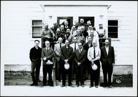
Photograph depicts group of twenty-four men standing on front steps of main office building. Handwritten annotations on recto of similar photograph: "OFFICE STEPS APPROX 1965 / TOP L-R / JULIEN ST. GEORGES / GEORGE TROWSDALE / HANS VELTMEYER / BOB LOVETT / KARL SHULTZ / LOTHAR TISCHLER / - "; "2ND / FRANK CLEMENTS [i.e Kliment?] / BILL PLUMB / HEWETT / - "; "3RD - / - / RENE PASIAUD / DICK [Stevens]"; "4TH / DOC NAVIN / VIC SARAKOSKI / - "; "5TH / CHARLIE GANDER / GORDON EDWARDS / AL FLANIGAN [i.e. Flanagan?] / ANDRE BEGUIN / CHARLIE BRONSON / JACK THORNICROFT". Information in above annotation supplemented with insight from individuals who contributed to Northern BC Archives Facebook Photo ID Project, contact archivist for more information in research file pertaining to this photograph.
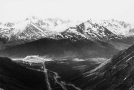
Photograph depicts mine valley and road in foreground. Cassiar plant visible in left midground, townsite in right midground. Southern mountain range in background.
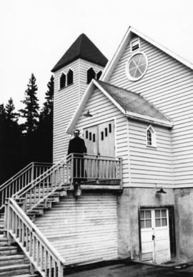
Photograph depicts priest wearing black cassock on front steps of Cassiar Catholic Church. Bell tower and trees in background. Handwritten annotation on recto of photograph: "FATHER POULET".
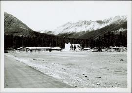
Photograph depicts building containing Cassiar's bar and snackbar, visible across ball field. This building originally housed school classrooms, movie theater, barber shop, and rec centre with three pool tables. Private liquor store originally located in far right of building. Liquor store was known to be the only legal bootleg liquor business in the province at the time, before it was transferred to Cassiar's government liquor store and replaced with a Sear's office. Catholic church and other buildings are visible behind trees in right midground. Road and field in foreground, valley and mountains in background. Community Centre located behind photographer, out of frame, curling rink on photographer's right.
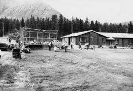
Photograph depicts men's ball game in foreground, spectators and cars visible behind backstop net. Bar and snackbar building in right midground, trees and mountain base in background. See item 2000.1.1.3.19.52 for information regarding bar and snackbar building.
Photograph depicts church building with what appears to be speakers mounted on roof above main entry. Trees in foreground and background. Handwritten annotation on recto of photograph: "All Saints Anglican Community Church".
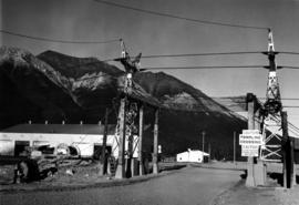
Photograph depicts a gravel road passing under crossing. Sign posted to pole reads "CAUTION TRAMLINE CROSSING CAUTION AVIOD PASSING UNDER MOVING BUCKETS". Garage stands in left midground, mountains in background. Handwritten annotation on verso of photograph: "1961".

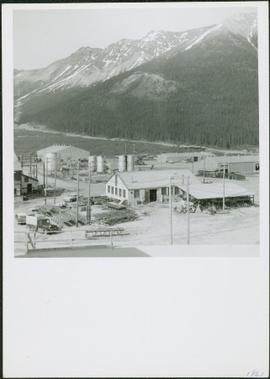
Photograph depicts tower and bucket tram in left foreground, plantsite in midground, mountains across valley in background. Dry rock storage building, mill, tailings pile, and many other buildings visible in plantsite. Handwritten annotation on verso of photograph: "1961".
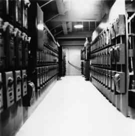
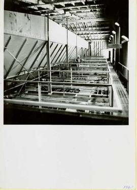
Photograph depicts hallway in power house building. Handwritten annotation on verso of photograph: "1961".
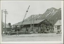
Photograph depicts a large shelter over building believed to be power house. Electricity lines cross midground and run to power house. A man can be seen crossing the foreground by steel frame supplies, and a second building is partially visible on right. Mountains stand in background and a crane can be seen operating in front of power house. Handwritten annotation on verso of photograph: "1961".
Photograph depicts various buildings in plantsite, vehicles and electricity lines throughout. Equipment garage stands in left background behind tank farm, carpenter shop in right background, machine and electrical shop in building semi-visible on far right. Mine road can be seen at foot of mountain in background. Handwritten annotation on verso of photograph: "1961".
Photograph depicts a car and two dump trucks near a small garage by road in mine. One man stands at garage site among tires and miscellaneous tools. Blasthole drills, shovels, and dump trucks visible in distance. Rocks in foreground, mountains in background. Handwritten annotation on verso of photograph: "1961".
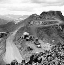
Photograph depicts buildings at various locations in mine: crushing plant (centre?) and what is believed to be the original tramline loading station on left. Mine road featured in center, blasthole drill visible near dump truck in midground. Mine valley in background. Photo believed to have been taken from mine's South Peak. Handwritten annotation on verso of photograph: "1961".

Photograph depicts dry rock storage building on left, mill in foreground, and tailings piles behind mill in midground. Mountains in background. Handwritten annotation on verso of photograph: "1961".
Photograph depicts a man wearing a hard hat standing at what is believed to be the dust collection system in the Cassiar mill. Sign on right reads "CAUTION NO WELDING, BURNING OR SMOKING IN THIS AREA." Handwritten annotation on verso of photograph: "1961".
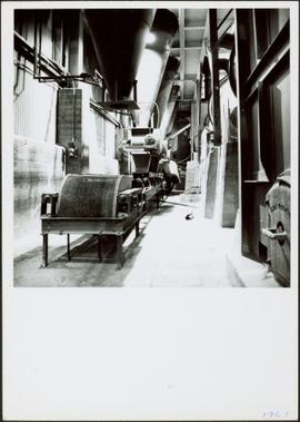
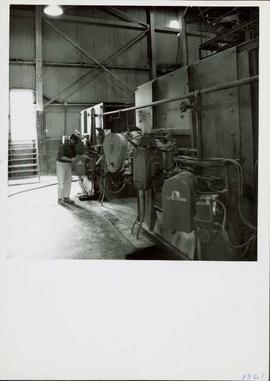
Photograph depicts interior of mill. Handwritten annotation on verso of photograph: "1961".
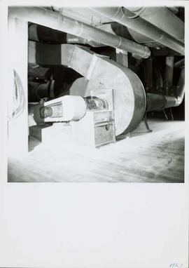
Photograph depicts a fan from the air system used to transport fibre throughout the mill system. It is believed that this photograph was taken on the top floor of the mill. Handwritten annotation on verso of photograph: "1961".
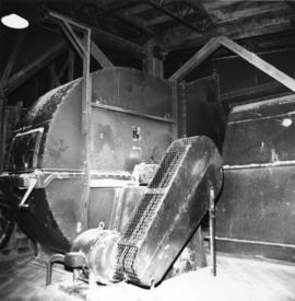
Photograph depicts fan-driven air system used to transport fibre throughout the mill system. It is believed that this photograph was taken on the top floor of the mill. Handwritten annotation on verso of photograph: "1961".
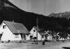
Photograph depicts four houses in line behind trees and steel drums. Road in foreground, mountains in background. Handwritten annotation on verso of photograph: "1961".
Photograph depicts a man near the diesel-fired burners of the ore dryers. The large pipes and valves above were part of the fuel supply system fed by Cassiar's fuel tank farm which also supplied the power house generators. The dryer section of the mill received ore from the crushing plant by tramline and truck. These burners blasted the ore with hot air, and dried ore to desired moisture content before it was sent to the dry rock storage building and stored for mill use. Handwritten annotation on verso of photograph: "1961".
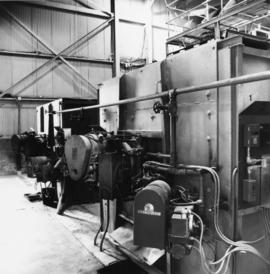
Photograph depicts the diesel-fired burners of the ore dryers. The large pipes and valves above were part of the fuel supply system fed by Cassiar's fuel tank farm which also supplied the power house generators. The dryer section of the mill received ore from the crushing plant by tramline and truck. These burners blasted the ore with hot air, and dried ore to desired moisture content before it was sent to the dry rock storage building and stored for mill use. Handwritten annotation on verso of photograph: "1961".
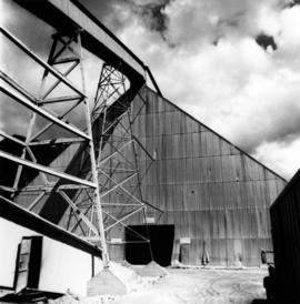
Photograph depicts front of dry rock storage building, conveyor visible above on left. Handwritten annotation on verso of photograph: "1961".
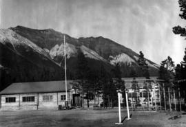
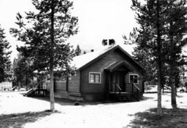
Photograph depicts long wood building speculated to be the Community Centre at Cassiar, B.C. Sports net stands in right foreground. Flag pole, barrel, and stand of trees can be seen in front of building. Mountains in background. Handwritten annotation on verso of photograph: "1961".

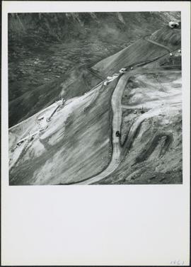
Photograph depicts mine area at Cassiar, crushing plant visible on left. Various mine buildings visible midground. Blasthole drills, shovels, dozers, and dump trucks can be seen on bench in foreground at 6430 elevation. Handwritten annotations on recto of photograph: "6"; "View looking NW from top of S. peak 6790 elev. on 6430 stripping bench on it and 6050 ore bench further down on left."; "July 1961".
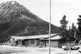
Photograph depicts long wood building believed to be the bar and snackbar at Cassiar B.C. Two men can be seen standing on one of three porches to building. Pole, car, and trees in foreground; unknown buildings and mountain base in background. Handwritten annotation on verso of photograph: "1961".
The item is a photograph slide reproduction depicting a wooden walkway set up during a flood in Prince George. There are multiple people on the walkway and a man on a raft next to the walkway. Annotation on the slide states, "1936."
The item is a photograph depicting the back of a white coloured house at 1711 Elm Street, Prince George. The house is located in the Millar Addition. Annotation on reverse side of photograph states, "1711 Elm at 17th N. edge of FG Park."
The item is a photograph depicting the front of a white coloured house at 1711 Elm Street, Prince George. The house is located in the Millar Addition. Annotation on reverse side of photograph states, "1711 Elm at 17th N. edge of FG Park."
The item is a photograph depicting a house with a blue car at 1705 Fir Street, Prince George. Annotation on the back of the photograph states, "1705 Fir St. - N. of F-C school at 17th."
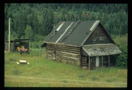
Image depicts an old log cabin at an uncertain location.

Image depicts 1690 Dogwood Street, on the corner of 17th Ave and Dogwood St. in Prince George, B.C. Also depicts a portion of 1670 Dogwood Street at left.
The item is a photograph depicting the front and side view of a white coloured house at 1699 5th Avenue in Prince George. Annotation on reverse side of picture states, "1675 5th Sept 94."
The item is a photograph depicting the front view of a white coloured house at 1699 5th Avenue in Prince George. Annotation on reverse side of picture states, "1675 5th Sept 94."
The item is a photograph depicting the Gaul residence at 1651 5th Avenue in Prince George. House is a proposed heritage building.
Image depicts 1650 Dogwood Street and 1670 Dogwood Street in the Millar Addition neighbourhood in Prince George, B.C.
The item is a photograph depicting the front of a grey house at 1643 5th Avenue, Prince George.
The item is a photograph depicting the front of a grey house at 1643 5th Avenue, Prince George.
The item is a photograph depicting the side view of a white coloured house at 1633 10 Avenue in Prince George. Annotation on reverse side of picture states, "983 Vanc. St."; however, this annotated is believed to be an incorrect identification of the photograph.
The item is a photograph depicting the front and side of a white house located at 1616 8 Avenue, Prince George. Annotation on back states, "Van Horlick to north of property / Alex 1616 8th - Trimble house."
This item is a photograph of a blue building at 1601 4th Avenue, Prince George. Building includes the Freemason Lodge.
The item is a 35 mm photograph negative of a five story blue and white apartment complex located at 1600 3rd Avenue, Prince George.

Image depicts the intersection of 15th Ave and Highway 97 in Prince George, B.C.
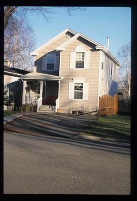
Image depicts 1598 Fir Street in Prince George, B.C.
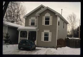
Image depicts 1598 Fir Street in Prince George, B.C.
The item is a photograph depicting the side of a beige house at 1589 7th Avenue, Prince George.
The item is a photograph depicting the front of a beige house at 1589 7th Avenue, Prince George.
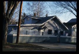
Image depicts 1590 Fir Street in Prince George, B.C.
The item is a photograph depicting a blue coloured house in the Millar Addition at 1570 Elm Street, Prince George. The house was previously used for veteran housing. Annotations on reverse side of picture state, "Millar Addition vet housing 1948."
The item is a photograph depicting a grey coloured house at 1570 Dogwood Street, Prince George. The house is located in the Millar Addition.