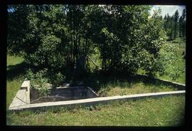
Image depicts an old tomb stone at an uncertain location, possibly Fort St. James, B.C.
Image depicts a tombstone, with the name and inscription written in what appears to be Chinese. It is most likely located somewhere in or near Kamloops, B.C.
Image depicts the tombstone of T.J. Menefee in the cemetery in Soda Creek, B.C.
Image depicts a totem pole at an uncertain location, possibly in Gitwinksihlkw, B.C.
Image depicts several individuals examining totem poles which are possibly undergoing a restoration process somewhere on Haida Gwaii.
Image depicts a view of the scenery at an uncertain location with numerous individuals, possibly tourists, present. It is possibly somewhere near the Fraser River.
Image depicts a view of the landscape at an unknown location with a group of people, possibly tourists, present. It is possibly near the Fraser River.
Image depicts a tractor with a claw lifting logs at a saw mill in Prince George, B.C.
Image depicts a patch of snow-covered ground with a sign that reads "Trail of 98," somewhere along the White Pass railway.
Image depicts Upper Fraser residential area during demolition of town site. Map coordinates 54°06'51.6"N 121°56'26.3"W
Image depicts a number of trailer homes in Tumbler Ridge, B.C.
Image depicts trailer homes in Prince George, B.C.
Image depicts a number of trailer homes in Tumbler Ridge, B.C.
Image depicts a trailer park by either the Fraser or Nechako River in Prince George, B.C.
Image depicts mobile homes for sale on Cowart Road looking northeast with Simon Fraser Bridge in background. Map coordinates 53°52'39.3"N 122°46'13.1"W
Image depicts a train in an uncertain location, though it is possibly Howe Sound in the background.
Image depicts a train in an uncertain location.
Image depicts the side of a train and the tracks it is on, somewhere in the Seton Portage area.
Image depicts what is possibly a train fuelling station at the GTP Roundhouse in Prince George, B.C.
Image depicts what is possibly a train fueling station at the GTP Roundhouse in Prince George, B.C.
Image depicts a train in the interior of the GTP roundhouse in Prince George, B.C.
Image depicts a train in the GTP roundhouse in Prince George, B.C.
Image depicts a train on the Hansard Bridge across the Fraser River looking west. Map coordinates 54°04'37.7"N 121°50'39.9"W
Image depicts a train and several unidentified individuals who appear to be waiting for it as it passes through Sinclair Mills, BC.
Image depicts a train track and several buildings in an unknown location.
Image depicts a train transporting wood planks, possibly in Prince George, B.C.
Image depicts a train carrying logs somewhere in Prince George, B.c.
Image depicts a train and a group of unknown individuals at the GTP roundhouse in Prince George, B.C.
Image depicts several trains at the Giscome mill site in Giscome, B.C. Map coordinates 54°04'19.7"N 122°22'04.7"W
Image depicts trains at the Grand Trunk Pacific railway roundhouse in Prince George, B.C.
Image depicts two unidentified individuals examining a thick log still attached to the machine that cut it down. It is located somewhere in Prince George, B.C.
Image depicts numerous trees in an uncertain location; the slide itself is labelled "T.T. Cutting," possibly meaning "Telegraph Trail Cutting."
Image depicts a small copse of trees boxed in by very small concrete barriers somewhere in Kettle Valley, B.C.
Image depicts a green car among some trees on Cottonwood Island.
Image depicts two old houses surrounded by numerous trees at an uncertain location.
Image depicts a stand of trees and a shed at Island Cache.
Image depicts a west-looking view of Trembleur Lake.
Image depicts a group of people preparing to depart on a trip. Location is uncertain, though it is possibly in Prince George, B.C.
Image depicts a snow-covered cabin and a mountain in the distance. It is located somewhere near Birken, B.C.
Image depicts a mountain in the distance. It is located somewhere near Birken, B.C.
Image depicts numerous skiers at the cabin located at Troll Lake on Tabor Mountain in Prince George, B.C.
Image depicts truncated spurs somewhere near McBride, B.C.
Image depicts the Tseax Lava Flow.